
Crazy weather week coming to the US: From searing heat to snow. Yes, snow.
The coming week will bring weather extremes of almost every stripe to the U.S.: From a baking heat wave in the Midwest and Northeast to an unseasonable chilly start in the Pacific Northwest.
And in the Rockies? Possibly snow − yes snow − in June.
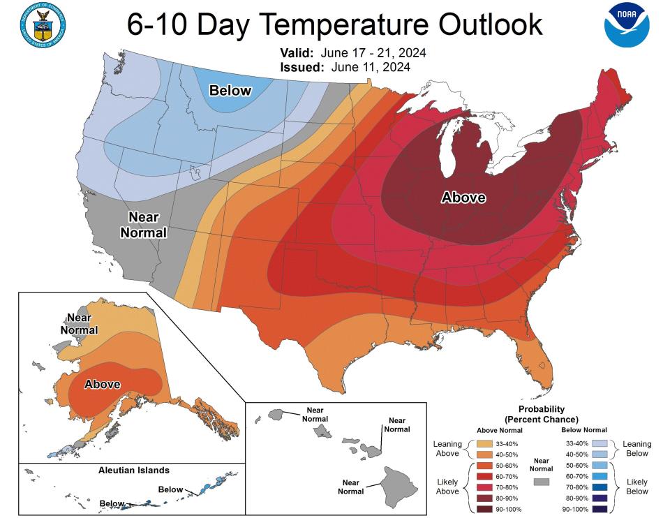
Scorching temperatures into the 90s are expected through the beginning of the week over the East and into the Midwest and Great Lakes region, the National Weather Service warned Sunday.
It's going to be so hot in the middle and eastern part of the country that Tom Kines, a meteorologist with Accuweather, expects it will make headlines.
“The Midwest, the Ohio Valley, the Great Lakes, the mid-Atlantic and the Northeast – this will be the first 90-degree temperatures a lot of these places have gotten so far this year,” he said.
The blistering temperature will last through next weekend.
“Some of these areas will get temperatures up into the 90s and near 100. You throw in humidity, which makes it feel 9 or 10 degrees higher than that, and for a lot of people it’s not going to be the best of weeks,” Kines said.
The heat wave isn’t entirely anomalous for this time of year, but it is coming earlier than usual.
“Typically it’s July and August when we get this kind of heat,” he said. “It’s definitely early.”
The National Weather Service’s Heat Risk map for Monday shows a broad splash of red, indicating major heat, reaching from West Virginia to Kansas.
The heat danger was up to purple in parts of Iowa, Illinois and Missouri.
That means a “level of rare and/or long-duration extreme heat with little to no overnight relief affects anyone without effective cooling and/or adequate hydration. Impacts likely in most health systems, heat-sensitive industries and infrastructure,” according to the Weather Service.
By Tuesday the extreme heat area covered large parts of Iowa, Wisconsin, Illinois and Michigan, and by Thursday had moved across into New York state and New Hampshire.
'It's June now and we're talking about snow'
While the middle and eastern part of the nation is baking, some areas of the northern Rocky Mountains will see much lower-than-average temperatures and even snow.
“They’re going to see some nights coming down into the 20s and low 30s, and up in the northern Rockies they’ll be getting some snow,” Kines said.
That snow will be falling at higher elevations, generally above 6,000 feet, so it won't impact that many populated areas. “But nevertheless, it’s June now and we’re talking about snow,” Kines said.
Temperatures there will gradually climb back to where they should be, in the 60s and near 70s, by the middle of the week, he said.
Want to flee the heat? Try the Pacific Northwest
In the Pacific Coast, Oregon and Washington state were looking at lower than normal temperatures. Cities such as Seattle will have a high of just 64 degrees on Monday and Portland, Oregon, will only reach 66 degrees.
For those looking to escape the heat, a quick trip to the Pacific Northwest might do the trick. While temperatures in the Seattle–Portland corridor would typically be in the lower to middle 70s at this time of year, they’re forecast to only reach as high as the mid-60s in the coming days.
“On Saturday, Seattle had a high of 60,” said Kines.
This article originally appeared on USA TODAY: US to get blistering heat, snow and unseasonably cold weather

