
Triangle schools delayed Wednesday due to dangerously cold weather. Snow chance this week
Arctic temperatures will conspire with brisk winds starting Tuesday night to bring North Carolina some of the coldest weather we’ve seen this season, prompting some school districts to delay the start of school Wednesday morning.
Two cold fronts will pass through
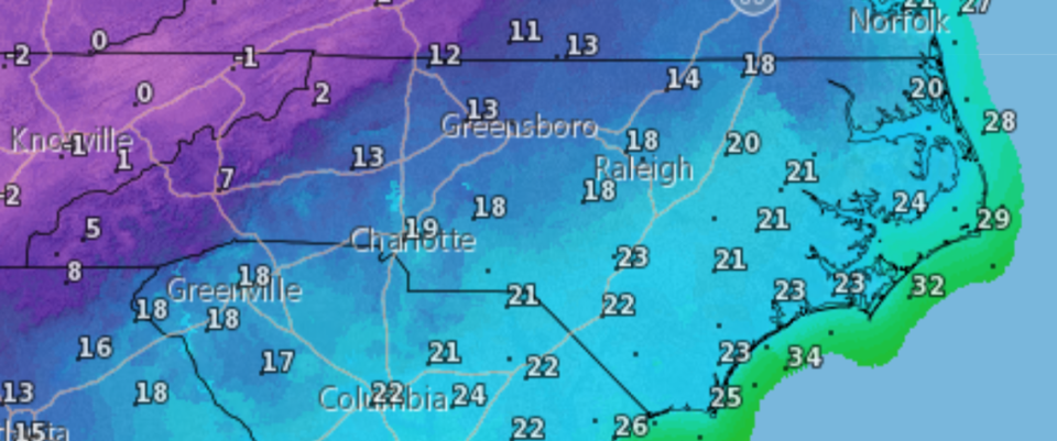
A pair of strong cold fronts affecting most of the country are to blame, and the first one began to appear in Raleigh and the rest of central North Carolina Tuesday afternoon. After topping out at 40 degrees around 10 a.m. Tuesday, the temperature began falling on its way to an expected low of 23 degrees Tuesday night. Periodic light rain seen through the afternoon is expected to end Tuesday night.
Wednesday’s high in Raleigh should be around 38 degrees, forecasters said, and the low Wednesday night will reach 17 degrees.
Triangle school opening delays
Wake County Public Schools will operate on a two-hour delay Wednesday because of the cold temperatures, potential for black ice and wind chill, which could make it feel as cold as 10 degrees. All before-school programs will be delayed or closed. Breakfast may be served at the principal’s discretion.
All Orange County schools will be on a three-hour delay Wednesday.
Durham County Schools will operate on a two-hour delay for students and staff.
We’ll update this story if other area school systems delay the start of school on Wednesday.
White flag shelters will open
Managers of shelters in Raleigh and across the Triangle have issued “white flag” alerts for Tuesday through Sunday nights, meaning extra space will be available to accommodate people who need to get out of the cold to stay safe.
Shelters open at 5 p.m. and close at 8 a.m. unless weather conditions dictate otherwise.
The shelter for males is at 401 W. Cabarrus St. in Raleigh; for females, the Bulla Building at 301 W. Jones St. Families will be sheltered at the Salvation Army, 1863 Capital Boulevard.
Durham County Library locations will operate as warming centers Wednesday through Saturday of this week and Monday and Tuesday of next week during normal business hours.
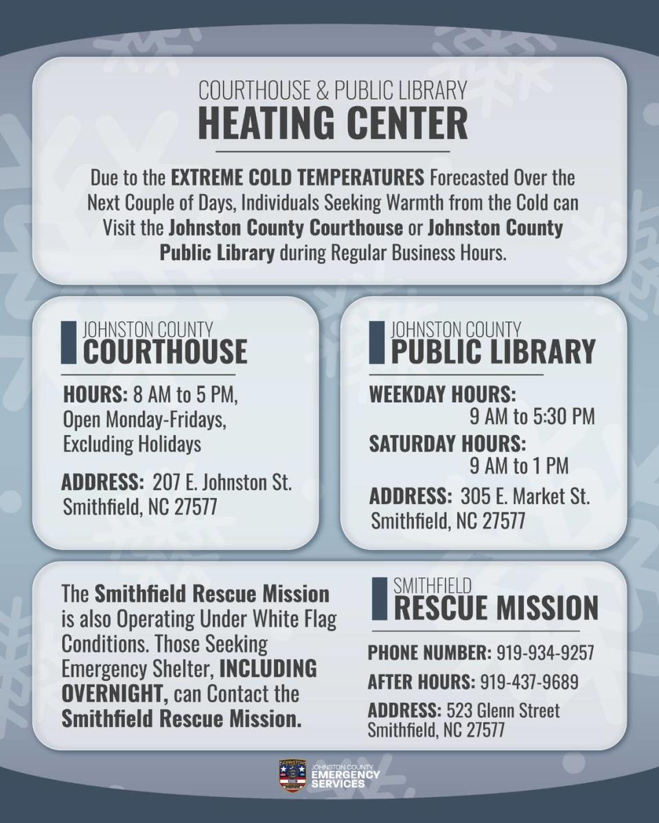
Officials said the Johnston County Courthouse and the Public Library of Johnston County in Smithfield will be open for those seeking warmth.
The courthouse at 207 E. Johnston St., Smithfield is open 8 a.m. to 5 p.m., Monday to Friday.
The Johnston County Public Library at 305 E. Market St., Smithfield, is open 9 a.m. to 5:30 p.m. on weekdays from 9 a.m. to 1 p.m.
The Smithfield Rescue Mission at 523 Glenn St., Smithfield, is operating under white flag conditions and will have overnight accommodations.
A second cold front and a chance of snow
Forecasters say there is a 40% chance of precipitation early Friday morning, with the chance of snow between 3 a.m. and 9 a.m. in Chapel Hill and Durham, while rain is expected in Raleigh. Little to no snow accumulation is expected.
After a slight warming on Thursday and Friday, another system will move in late Friday, forcing temperatures into the teens overnight. Saturday’s high will be just 33 degrees, forecasters say, and Sunday’s, 37 degrees.
After an overnight low around 21 degrees Sunday, Monday’s high will be in the low to mid-40s, and Tuesday it should be a more typical 55 degrees.
While miserable, the cold temperatures this week aren’t likely to break records.
National Weather Service data show the record low for Jan. 17 for Raleigh is -1 , set in 1943. The lowest maximum temperature for the day is 20 degrees in 1977. This Jan. 20, expected to top out at 33 degrees, will be warmer than the record lowest maximum for the date, 28 degrees in 1985.

