
This drone captured scenes inside the deadly Hurricane Beryl. The data helps forecasts
Within the 25-foot waves and violent winds of the disastrous Hurricane Beryl, one 23-foot long neon orange sailboat-like device stood out against dark ocean water with a front-row seat to the eye of the storm. The object in question wasn’t a boat that got too close to the storm, but an uncrewed hurricane drone called the Saildrone Explorer.
Unlike boats or planes with people in it, the Saildrone Explorer can hold its own on the sea surface in the eye of a hurricane — and send back pictures and data to help scientists forecast storms. Last week, it went inside Hurricane Beryl, while it was a Category 4 storm just south of Puerto Rico.
The drone intercepted the edge of the hurricane and sustained waves of over 25 feet and wind gusts of 53.48 knots (or about 61 mph), according to Saildrone Inc.
The device is one of the latest innovations in collecting data from hurricanes. It can collect important air and sea data from storms and is able to withstand the strongest of them, as seen with Hurricane Beryl, which eventually upgraded to a Category 5, making it the earliest storm to reach that category on record.
“You have to get pretty lucky to get a hurricane. So that’s one advantage of the Saildrones,” said Greg Foltz, principal investigator for Saildrone research at the National Oceanic and Atmospheric Administration. “We can actually move them and get a lot more data that way, by moving them into the path of hurricanes.”
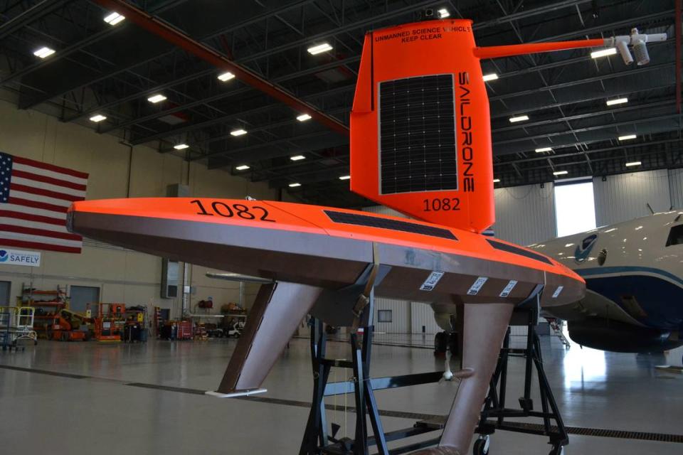
The drone is one of 12 Saildrones to be deployed this hurricane season to collect data for NOAA. Saildrones are 1,000-pound uncrewed surface vehicles (USV) powered by wind and solar energy.
This Saildrone was expected to deliver hurricane monitoring data for NOAA beginning the first week of August, but it deployed from St. Thomas early to intercept Hurricane Beryl, according to Saildrone Inc. Director of Marketing Jenn Virskus.
Foltz said the idea behind the Saildrone was to try to get unique measurements at the bottom of the hurricane, where it meets the ocean’s surface.
“[It] is very difficult to do and hadn’t really been done in the past, except if there happened to be an instrument in the path. So the idea was to put something that could be actively directed into a hurricane’s path and then measure continuously as a hurricane went over it,” Foltz said.
Saildrones can collect a range of hurricane data including wave height, ocean currents and surface air temperature. The data is used directly in hurricane forecasting and advisories. Last hurricane season, it was used in dozens of forecasts and was able to warn people about the heights of waves or rip currents in the ocean, Foltz said.
One of the Saildrones is even a world record holder.
The 2024 Guinness Book of World Records includes for the first time, the “highest wind speed recorded by a USV,” earned during the Saildrone’s maiden voyage in 2021, into the 126 mph winds of Category 4 Hurricane Sam.
Other hurricane-tracking devices
Perhaps the best-known way scientists collect data inside hurricanes is the hurricane hunters. NOAA and the Air Force collaborate on flights directly into the heart of storms, where researchers on board measure all kinds of data that helps feed the massive global supercomputer models that predict where storms might go next.
The hurricane hunters flew at least five missions into Beryl to collect and quality check data in storms before sending it to forecasters. Researchers inside the plane drop devices known as “dropsondes” into the storm, and these remote devices send important info back to scientists at the National Hurricane Center.
READ MORE: How drones by air and sea help Florida forecasts. ‘We can steer these into hurricanes’
Saildrones, Foltz said, are a complement to those efforts.
“It’s not like we’re going to replace anything that’s already out there collecting data,” Foltz said. “It’s like a big coordination effort when there’s a hurricane hunter flying into a hurricane and we have a saildrone close by, so that’s fun.”
Other NOAA data-collecting devices include an array of technology that goes in the water or stays in the air. For example, underwater gliders collect water-related data like temperature and salinity levels.
The future of the Saildrone
Foltz hopes to keep building on what the drones can do. He thinks there’s more to be done with getting data on things like sea spray, air bubbles in the ocean and better heat transfer measurements by adding more sensors to the drones.
“The main way we envision this helping people in the longer run, is to improve the models and proof of hurricane intensity forecasts for people, give them more time, make them more aware and be able to evacuate and prepare,” Foltz said

