
Finally a rain-free weekend? Gorgeous summer weather ahead in southern Ontario
Although summer weekends across southern Ontario haven't been complete washouts, nearly every weekend since early April has included a period of showers and thunderstorms.
Will that trend continue this weekend?
MUST SEE: Too hot to sleep? These hacks can help
The upcoming weekend does include the all too familiar risk of scattered showers and thunderstorms, but the rain won’t be as widespread and some places will actually get through the weekend without seeing more rain. Abundant sunshine and warm temperatures are on the agenda for most!
For more details on this weekend and next week, continue to read the forecast details below.
Weekend kicks off with some instability and storm chances
We will kick off the weekend with sunshine and near seasonal temperatures during Friday afternoon.
However, Friday afternoon is also one of the times when we do have a risk for thunderstorms, especially north and west of Toronto Area. While many places will stay dry, the storms that do develop will produce torrential downpours.
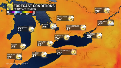
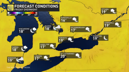
The risk for thunderstorms will end towards sunset. Friday night will be partly cloudy and mild. The humidity won’t be oppressive, but it will be noticeable.
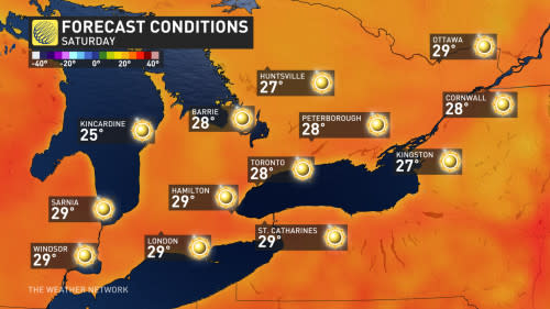
Saturday: A spectacular summer day!
Saturday will be a spectacular summer day with full sunshine and temperatures on the warm side of seasonal. This will be ideal weather for being at the beach or on the water, but don’t forget the sunscreen!
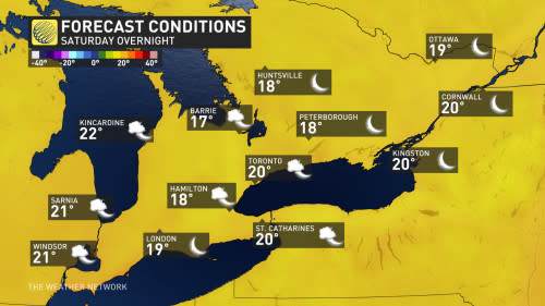
Saturday night will be mostly clear and mild.
RELATED: What's the temperature 'sweet spot' for swimming in lakes and rivers?
Sunday will mostly sunny, hot and humid through early afternoon. However, during the afternoon and evening we will have an increasing threat for thunderstorms, including a risk for strong to severe storms, especially for areas to the west of Toronto.
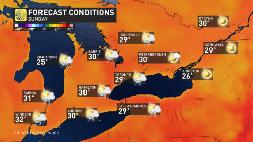
Showers and thunderstorms are likely Sunday night.
Thunderstorm threat returns next week
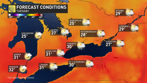
Hot and humid conditions are expected for Monday and Tuesday of next week with periods of sunshine. However, the very muggy conditions will also bring the threat for a couple rounds of showers and thunderstorms, and even a risk for strong to severe storms.
A cold front will track across our region during Wednesday or Wednesday night. This will usher in cooler temperatures and much lower humidity.
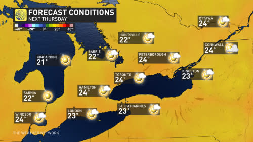
Thursday will be the coolest day of the week, but still comfortable with a mix of sun and clouds.
Abundant sunshine and pleasant temperatures are expected for Friday, as we conclude next week and head into the following weekend.
At this point, it looks like next weekend will feature abundant sunshine and a warming trend. But in the meantime, we hope that you enjoy this weekend and please check back next week for a detailed update on the weekend and the rest of July.
WATCH: Why you should ditch that fun floatie this summer
Thumbnail image courtesy: Getty Images

