
Tornado watch, severe thunderstorm warning issued as dangerous weather hits Midlands
As powerful storms bear down on South Carolina Tuesday, a tornado watch was issued for the Midlands, according to the National Weather Service.
A wind advisory previously went into effect at 6 a.m.
The tornado watch is in effect until 6 p.m. in both Richland County and Lexington County, as well as Calhoun, Clarendon, Fairfield, Kershaw, Lee, Newberry, Orangeburg, Saluda and Sumter counties, the National Weather Service said.
Shortly after 1 p.m., a severe thunderstorm warning was issued for parts of Richland, Lexington, Fairfield, Newberry, Saluda, Aiken and Edgefield counties, according to the National Weather Service. The warning is in effect through 2 p.m., as a line of storms was moving at 50 mph, the National Weather Service said.
“Remain alert for a possible tornado!” The National Weather Service said. “Tornadoes can develop quickly from severe thunderstorms. If you spot a tornado go at once into the basement or small central room in a sturdy structure.”
Additionally, the National Weather Service said anybody on or near Lake Murray should move away from the water and take shelter.
This announcement came hours after a flood advisory was issued for Columbia, and flood warnings were put in place in other counties across the Midlands, according to the National Weather Service. Possible flooding of the Congaree River could impact both Richland and Lexington counties, the National Weather Service said.
The risk of flash flooding is low but possible, especially in the northern parts of the Midlands and in urban areas where drainage is poor, National Weather Service meteorologists said in a Tuesday morning briefing. There is a greater risk of river flooding beginning Wednesday, according to the briefing.
But powerful, gusty winds remain the greatest threat posed by the storms that are moving into the Columbia area, the National Weather Service said.
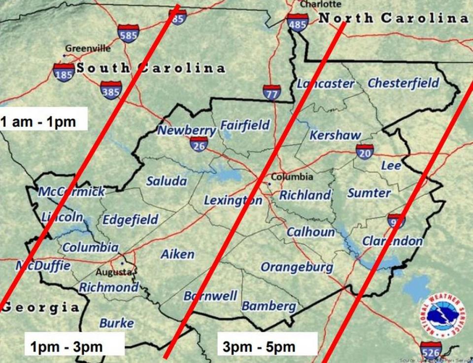
The storms are expected to increase in strength by the afternoon, and will remain a threat into the night, according to the briefing. The Midlands can expect the greatest impacts between noon and 6 p.m., but the effects will be present hours before and later, the National Weather Service said.
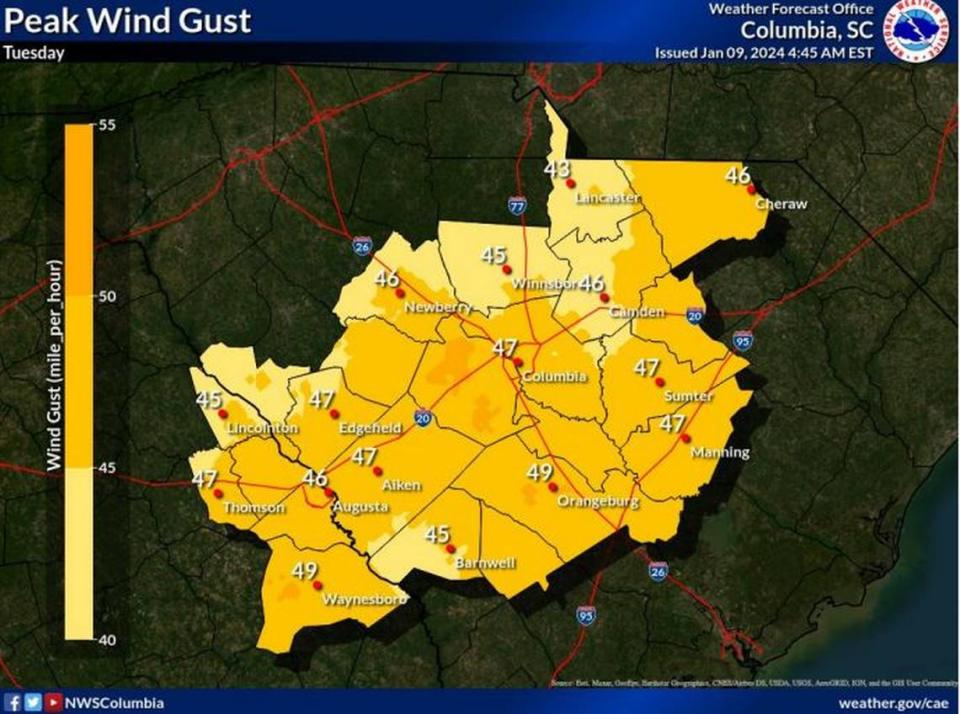
Strong winds are predicted, with powerful gusts that could reach 45 mph, according to the briefing. Some wind gusts could be enhanced by thunderstorms and might exceed 70 mph, the National Weather Service said.
At the peak of the storms, maximum sustained winds outside of the thunderstorms are predicted to be at about 30 mph in the Columbia area, according to the briefing.
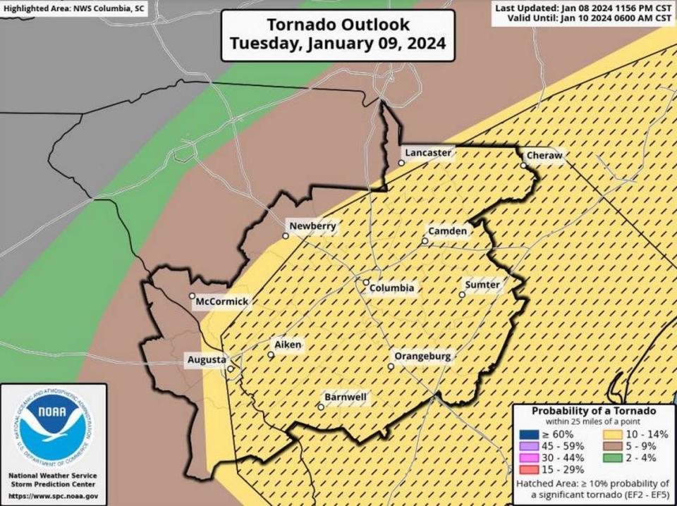
Additionally, there’s the potential for a few tornadoes to be embedded within lines of storms, and a significant EF2+ tornado, with gusts as powerful as 135 mph, is possible, the National Weather Service said.
The wind advisory is in effect until at least 10 p.m., meteorologists said.
Gusty winds will blow around unsecured objects.
Powerful winds and tornadoes could cause considerable damage to trees and branches, in addition to structures including mobile homes, roofs and outbuildings. Vehicles would also be under siege in the case of a tornado.
Damage to trees and branches creates the possibility of downed power lines and outages.
As of 11:45 a.m., more than 19,000 outages were reported in South Carolina.
Meteorologists also urged drivers to use caution on Tuesday because winds this strong can make driving difficult.
This prompted most Midlands school districts to close buildings and switch to e-learning for students on Tuesday.
“If you must drive during the worst of the weather, adjust your speed and follow distance accordingly,” the South Carolina Department of Public Safety said on social media.
Strong to severe thunderstorms and heavy rainfall is also included in a hazardous weather outlook for the Columbia area.
There is a 100% chance of precipitation in Columbia, and more than an inch of rain is possible Tuesday, the forecast shows. Localized amounts in other areas of the Midlands could be higher. Previous rainfall predictions called for more precipitation to accumulate, but have since been reduced because the storms are expected to be fast moving, according to the briefing.
“Most flooding deaths occur in vehicles,” the National Weather Service said. “Never drive through a flooded roadway or around barricades. Turn around, don’t drown.”
Even after the storms move out of the area, the effects are expected to linger. Conditions on Wednesday morning and afternoon are predicted to be breezy, with wind gusts potentially exceeding 30 mph, according to the briefing.
There won’t be much time before more severe weather is expected to affect the Midlands, as the potential for powerful thunderstorms with strong winds and a 90% chance of rain is in the Friday forecast, according to the National Weather Service.

