
New front in dispute over RDU quarry: a potential error in Umstead park boundary
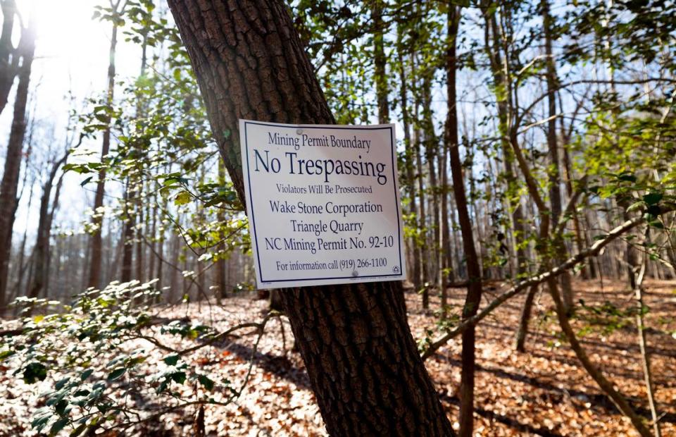
Wake Stone Corp. plans to create a rock quarry on 105 acres it has leased from Raleigh-Durham International Airport.
Now opponents of the quarry say they’ve discovered a 48-year-old surveying error that reduces the airport’s property by as much as 14 acres. They say that land was purchased by the National Park Service in 1937 and turned over to the state a few years later for what is now William B. Umstead State Park.
They say the error was made in 1976 when RDU purchased what’s known as the Odd Fellows tract for a runway project that was never carried out. The survey placed the northern boundary of the Odd Fellows property more than 120 feet too far north, essentially transferring a long strip of park land to the airport, said Jean Spooner, who heads The Umstead Coalition.
The group has asked the airport and the state to have the land resurveyed to determine the actual boundary.
“We need to correct this oversight and ensure that the land given to our state to preserve and protect is preserved and protected,” said Spooner, speaking at a press conference a few feet from the disputed boundary.
In addition to adding up to 14 acres to Umstead State Park, the change in the boundary could affect the development of a quarry on RDU land. Wake Stone plans to build a sound wall between the site and the park, and that wall and a planned perimeter road next to it would have to be moved south, reducing the size of the quarry pit.
Wake Stone Corp. said in a statement Thursday that any dispute over the boundary would be between the RDU Airport Authority and the state.
“If the boundary of the Odd Fellows parcel is moved, RDUAA will inform us and we will adjust our plans accordingly,” the company said.
The Umstead Coalition shared its findings about the boundary with state Division of Parks and Recreation director Brian Strong last month. A spokeswoman for the division referred questions to the Department of Administration.
Asked about resurveying its property, RDU spokeswoman Crystal Feldman said the state “has not made us aware of any potential issues with the boundary between airport property and park land. We will work with the state to determine what, if any, steps are needed if we receive new information.”
Researcher notices discrepancy in the records
The apparent error was found by Natalie Lew, an opponent of the quarry who has done extensive research into how the airport came to acquire land near the park decades ago. In reviewing tax maps and other records, Lew noticed that the boundary between the park and property owned by the International Order of Odd Fellows had shifted.
Lew traced the change to the airport’s purchase of the property in 1976. Minutes of the Airport Authority board from June of that year show the airport planned to acquire about 69 acres from the Odd Fellows, she said. Minutes from the next month’s meeting show that board members were surprised to learn they had actually bought 83, Lew said.
“They clearly acknowledged that there was a 14-acre discrepancy,” she said.
Lew and The Umstead Coalition say they determined the size of the error by taking the dimensions of the property the National Park Service purchased in the 1930s and measuring from an agreed-upon marker on the northern end. They also note that earlier maps show a small stream joining Crabtree Creek on the park’s property, but that after the line was moved the confluence of the streams was on the RDU land.
“It was kind of buried in the public record,” said Spooner.
The Umstead Coalition and other quarry opponents have tried several legal strategies to prevent Wake Stone from mining the RDU land. The group failed to persuade the courts that the airport’s mineral lease with the company was illegal or to stop the state from modifying the mining permit to allow Wake Stone to expand.
But it still hopes a court will block a permit the company needs to build a bridge over Crabtree Creek to connect the RDU site with the existing Triangle Quarry. And it’s trying to get the state to enforce a clause that was once part of the Triangle Quarry mining permit that would force the company to cease operations in 2031.
The boundary discrepancy was only brought to light because of the fight over the quarry, Spooner said. The land on either side is currently all wooded, and the state had long hoped to eventually acquire the Odd Fellows tract and have it added to the park.
What’s needed now, Spooner said, is a formal survey by the state to confirm the group’s research.
“We’re confident that we’re correct,” she told reporters. “Otherwise we wouldn’t have you here today.”

