
Heavy rainfall to hit Dallas-Fort Worth. Blame tropical disturbance from Gulf of Mexico
A tropical disturbance coming from the Gulf of Mexico will bring rain and cool temperatures to Dallas-Fort Worth this week.
The weather system will move northwest across the state this week, bringing heavy rainfall to South and Central Texas, said Allison Prater, meteorologist at the National Weather Service’s Fort Worth office.
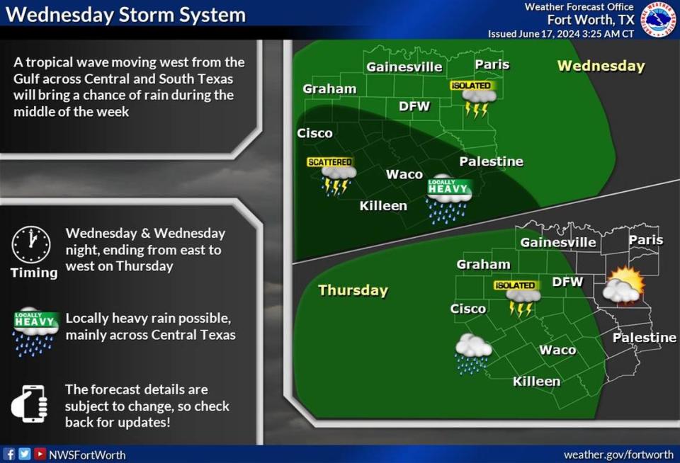
North Texas will also see an impact from the tropical disturbance, with storms in the forecast for Monday, Tuesday and Wednesday.
Scattered storms are possible over Monday afternoon, mainly for areas southeast of the Metroplex around Palestine and Waco. Over Tuesday afternoon, Dallas-Fort Worth has around a 20% chance of isolated storms, Prater said.
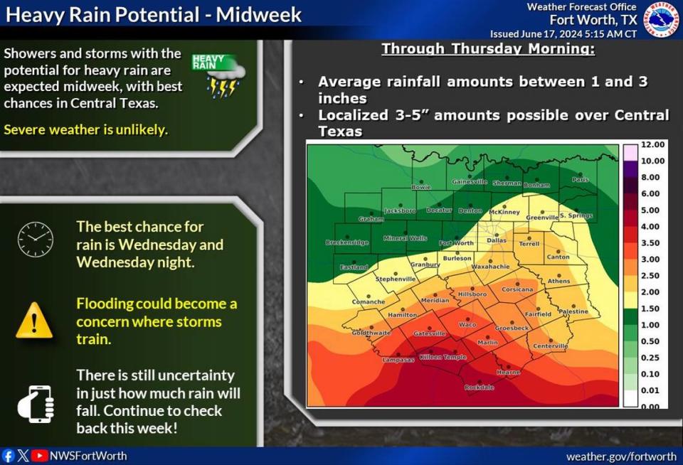
Wednesday will be the best opportunity for rain in North Texas this week, with a 30-40% chance. The main weather threats on Wednesday will be thunderstorms, heavy rain and flash flooding, Prater said.
“We’re not expecting severe weather at this time,” Prater said.
⚡ More trending stories from our newsroom:
→As Fort Worth population booms, pushback against new apartments isn’t budging
→ What Kevin Costner had to say to Mac Engel about 'Horizon'
→ Will Fort Worth Stockyards lose historic character with $1B expansion? Here’s what we know
Along with rainfall totals ranging from 1 to 3 inches this week, temperatures will cool down in North Texas.
Monday and Tuesday’s high is in the low to mid-90s, Prater said. Wednesday will be the coolest day of the week with temperatures in the low to mid-80s.
Overnight Wednesday into early Thursday, storms will begin moving out of North Texas and the heat will return.
Temperatures on Thursday and Friday will creep back into the low 90s, pushing its way back to mid-90s over the weekend. As the heat comes back later in the week, so will clear skies.
“We’ll be dry in the Metroplex through the weekend,” Prater said.
A tropical disturbance is different from a tropical storm or hurricane.
The NWS defines a tropical disturbance as a weather system with organized convection that originates from the tropics or subtropics area. Essentially, a tropical disturbance is a broad area of pressure.
When it comes to tropical storms or hurricanes, it’s all about wind speeds.
A tropical depression has maximum sustained surface winds at 38 mph or lower, according to the NWS. A tropical storm is when the maximum sustained surface winds are between 39 and 74 mph, while a hurricane has maximum sustained surface winds of 74 mph or higher.
Hurricane season is in full swing with the National Oceanic and Atmospheric Administration predicting above-normal activity in the Atlantic basin this year. NOAA is forecasting a range of 17 to 25 named storms, with 8 to 13 of those forecast to become hurricanes.
