
Hours of ice cancels schools, buses in eastern Ont., Quebec, still more to come
School and bus cancellations racked up early Thursday morning, as a lengthy period of freezing rain made for extremely slick and icy conditions across eastern Ontario and Quebec first thing. In Ottawa, 15 hours of freezing rain was reported before dawn on Thursday.
This won't be the last of it, either.
MUST SEE: How to stay safe during a winter power outage
After Thursday morning's commuting nightmare, another round of icy precipitation is expected on Friday, prompting additional warnings for parts of the region. Freezing rain will target very similar regions once again, with drivers being warned to plan ahead and adapt to the changing, and deteriorating conditions.

*Ice coats Montreal streets Thursday morning. (Kevin Cloutier/MétéoMédia)
Thursday overnight into Friday
Forecasters are tracking a second freezing rain set-up in the same region Thursday overnight through Friday. While there's still some uncertainty at this time, very similar ingredients are present for more ice build-up and slick travel.

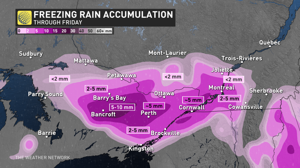
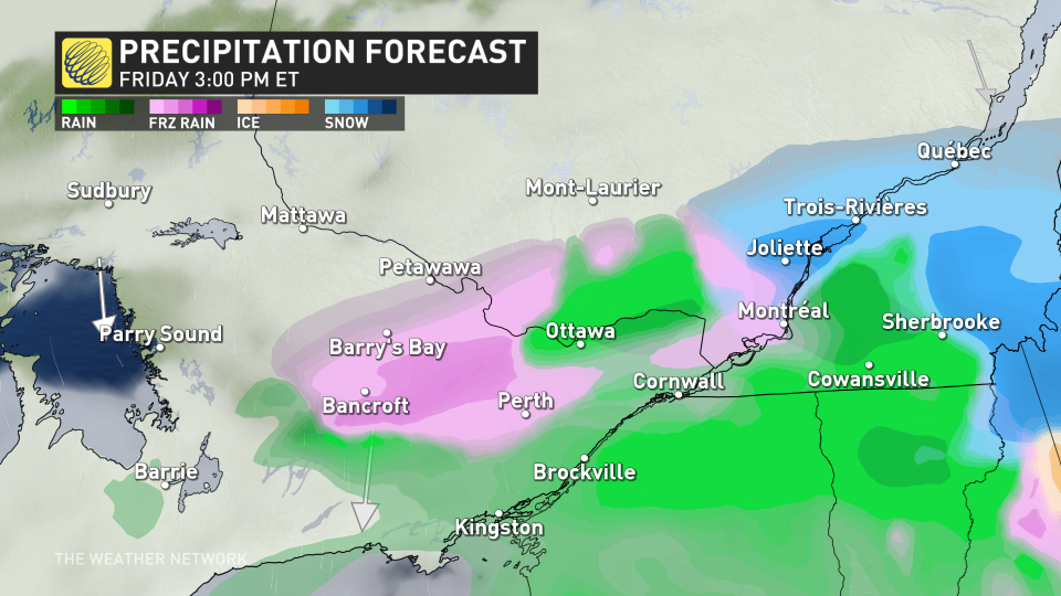
By Friday morning, freezing rain is expected to spread into the same region of eastern Ontario, eventually moving into Montreal and the southern St. Lawrence. Stubborn cold air at the surface will allow the falling rain to freeze on contact with roads, sidewalks and trees, creating another glaze of 2-5 mm of ice throughout the day on Friday.
Some areas near Bancroft may see 5-10 mm of ice accretion. This will not only create slippery surfaces on untreated objects, but also the risk for a few localized power outages.
Where this forecast gets tricky is in the storm's track, and how far north milder air may get.
Parts of these regions may start with freezing rain, but an afternoon switch over into rain is possible if temperatures can rise above 1°C. If this occurs, it may limit the ice build up for Ottawa, Montreal and into Kingston, as well.
There is higher confidence that Algonquin remains in the freezing rain event, before clearing through the day on Saturday.
Freezing rain warnings were issued for parts of southern and western Quebec on Thursday morning.
Drivers are urged to slow down in slippery conditions. Watch for taillights ahead and maintain a safe following distance. You can also check current highway conditions before venturing out during this time.
Ice buildup may cause tree branches to break, as well, and utility outages may occur.
DON’T MISS: Winter takes a breather in major Canadian cities with January thaw
A couple days of colder weather are forecast early next week, especially for eastern Ontario, but much milder weather and early spring-like temperatures are forecast for the second half of next week, continuing well into the first week of February, as well.
However, winter is not over. We are watching the potential for an extended stretch of colder winter weather from mid-February through early March.
Stay with The Weather Network for the latest on your forecast across Ontario and Quebec.

