
Dangerous Hurricane Beryl blasting Jamaica while racing across Caribbean
•Beryl crossed a portion of the Windward Islands as an intense Category 4 hurricane with maximum sustained winds of 150 mph Monday
•Beryl is the strongest hurricane on record to hit portions of the Windward Islands so early in the season and the earliest 165-mph Category 5 hurricane on record for the Atlantic basin
•AccuWeather meteorologists warn that Beryl will reach part of the United States after its trek through the Caribbean
 |
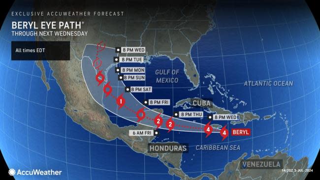
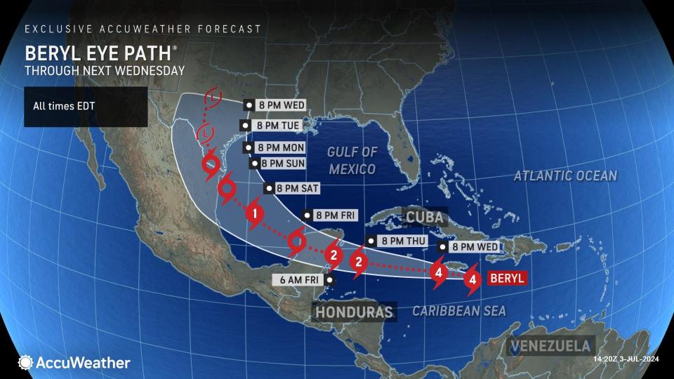
Hurricane Beryl will continue to churn west-northwestward, with significant risks to lives and property coming to areas over the central and northwestern Caribbean for the balance of this week. AccuWeather meteorologists have deemed there will be no threats from Beryl along the Atlantic coast of the United States. Still, interests along the Texas portion of the Gulf Coast should monitor the situation closely, as the chances of direct impacts are increasing.
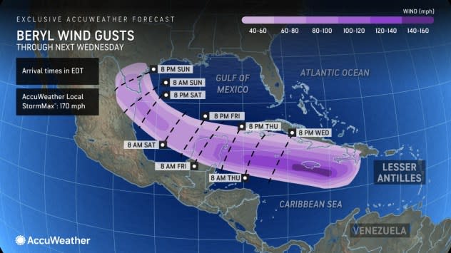
Quick-moving Beryl tore across the Windward Islands with a path of destruction on Monday. The smaller islands south of St. Vincent and areas just north of Grenada bore the storm's full Category 4 fury, with maximum sustained winds of at least 150 mph. The eye passed directly over the island of Carriacou at 11:10 AST. Late Monday evening, Beryl strengthened to Category 5 status (sustained winds of 157 mph or greater), with sustained winds reaching 165 mph Monday night. It has since lost wind intensity and is a Category 4, but remains a dangerous storm.
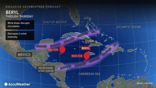
"Beryl is now scraping along the south coast of Jamaica on Wednesday," AccuWeather Lead Hurricane Expert Alex DaSilva said.
 |
As of Wednesday afternoon, Beryl remained a dangerous Category 4 hurricane as it encountered Jamaica with sustained winds of 140 mph. Beryl was moving west-northwestward at 18 mph. The eye passed less than 50 miles to the south of Kingston, Jamaica, which put part of Beryl's destructive eyewall near the southern coast of the island.
Factors affecting Beryl's intensity have been much warmer-than-historical-average waters and light breezes in the path of the hurricane through Tuesday night. When these breezes, known as wind shear, become strong, they can lead to the loss of wind intensity for an established tropical system.
"Through much of the balance of Beryl's life over water beyond Wednesday night, the hurricane should encounter stronger wind shear," AccuWeather Chief On-Air Meteorologist Bernie Rayno said.
 |
"Interaction with the larger landmasses of the Greater Antilles in the central and western Caribbean should begin to take the edge off Beryl's intensity as well later this week," Rayno added.
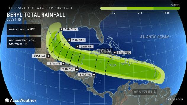
Even if Beryl loses some wind intensity during the latter part of the week, it will remain a dangerous hurricane. It is likely to produce torrential rain, flooding, mudslides, damaging winds, pounding seas, and a storm surge along its path and many miles away from its center.
 |
Puerto Rico and the U.S. Virgin Islands have escaped Beryl's wrath. As Beryl continues west-northwestward, portions of the Dominican Republic, Haiti and southeastern Cuba will experience moderate impacts from rain, wind and seas into Wednesday night.
Beryl's eyewall was passing near the south coast of Jamaica during the afternoon hours on Wednesday.
 |
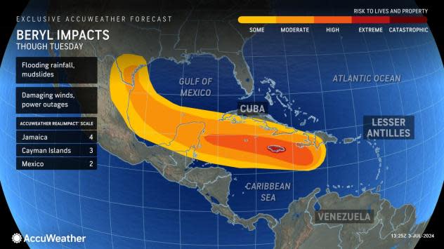
Jamaica will experience extreme risk to lives and property Wednesday as the powerful hurricane has the large island, home to nearly 3 million people, in its sights. The AccuWeather RealImpact™ Scale for Hurricanes for Jamaica is a 4. Due to Beryl's intensity on Wednesday, the devastation in part of the island nation may be similar to that of portions of the Windward Islands.
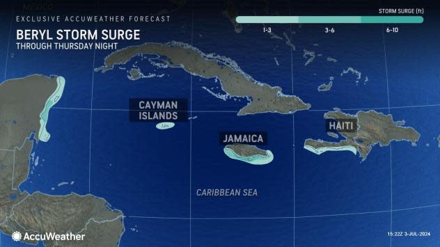
Destructive winds with life-threatening flooding rain and storm surge flooding are anticipated in Jamaica for several hours on Wednesday. A life-threatening storm surge of 6-10 feet is forecast on the southern part of the island. Only the short duration of hurricane conditions may limit impacts somewhat on the island.
"Only one hurricane has ever affected Jamaica during July," AccuWeather Meteorologist Jesse Ferrell said, "Category 4 Hurricane Dennis in 2005 did not make landfall but killed one person and caused a lot of damage."
 |
If Beryl manages to wobble northward just a bit and make landfall in Jamaica, it would be the first July hurricane to do so since records have been kept since the 1800s.
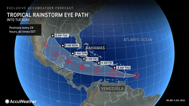
Beryl will continue to motor along over the western Caribbean later this week. The AccuWeather RealImpact™ Scale for Hurricanes for the Cayman Islands is a 3 and for Mexico it is a 2. As Beryl continues to move along an assessment of the RealImpact for the U.S. (Texas) will be considered in the coming days.
Beyond Jamaica, Beryl will continue to track slightly north of west in the short term. However, the influence of high pressure to the north over the southern U.S. is likely to waver.
"If the high pressure area was to remain strong, Beryl would make landfall in southeastern Mexico late Thursday night or Friday morning and then remain mostly over land for its duration," Rayno said. "But if the high weakens just a bit, and we are seeing signs of that trend, it will allow Beryl to take a more north-northwesterly track, in which case it may avoid more land and get into the southwestern Gulf of Mexico as a formidable hurricane instead of a chopped-down tropical storm that encounters more land."
 |
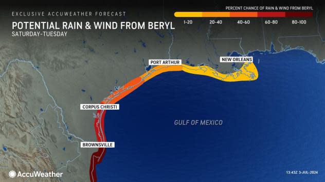
Because of the increasing potential for Beryl to turn more to the north soon after reaching the northwestern Caribbean, interests in the U.S., especially the Texas coast, should closely monitor the hurricane's progress and forecasts by meteorologists.
AccuWeather meteorologists have given the Atlantic coast of the U.S. and the Florida Peninsula the all-clear from Beryl's impacts, AccuWeather Chief Meteorologist Jonathan Porter said, but that is not the case for other portions of the Gulf Coast.
 |
"From Panama City, Florida to New Orleans, there is a low risk of direct impacts from Beryl, but from about Corpus Christi to Brownsville, Texas, the risk increases significantly due to the potential for Beryl to have more direct impacts," Porter explained. "That southern portion of the Texas coast is the zone we have to really watch."
Despite the risk, Beryl would not approach southern Texas with the same intensity as that of the Windward Islands. However, there could still be significant rain, gusty winds and storm surge this weekend with at least some to moderate risk to lives and property.
Should the storm's forward speed decrease as it approaches the western Gulf coast this weekend, the potential for excessive rainfall and flooding in Texas may increase.
Chris, the third tropical storm of the 2024 Atlantic hurricane season, formed this past weekend out of a tropical rainstorm that AccuWeather meteorologists had been tracking for over a week as it crossed the Caribbean. That storm diminished on Monday after making landfall over northeastern Mexico.
 |
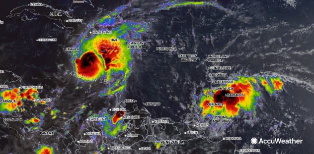
This image focused on the Caribbean was taken on Wednesday morning, July 3, 2024, and shows Beryl as a Category 4 hurricane (left of center) near Jamaica, and a tropical rainstorm (right of center) approaching the Windward Islands. (AccuWeather Enhanced RealVue™ Satellite) |
Thousands of miles farther to the east over the south-central Atlantic, another mass of showers and thunderstorms, referred to as a tropical wave, pushed off of Africa early last week. That system has been showing some signs of organization and was dubbed a tropical rainstorm by AccuWeather meteorologists late last week to raise awareness.
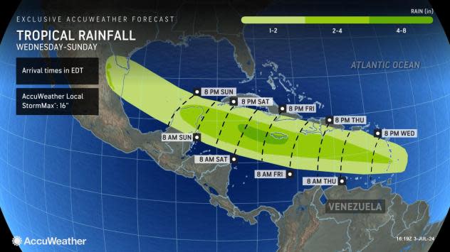
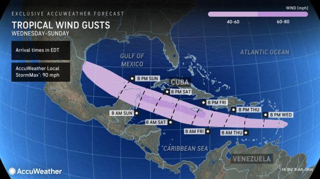
At this time, there is a low to moderate risk of the system evolving into a tropical storm or hurricane this week as it takes a very similar track to Beryl just days earlier. However, because waters have been churned up by Beryl in the path of the system, it is unlikely to reach the same intensity as Beryl.
Interests in the Lesser Antilles, especially the Windward Islands once again, should closely monitor the rainstorm's progress.
 |
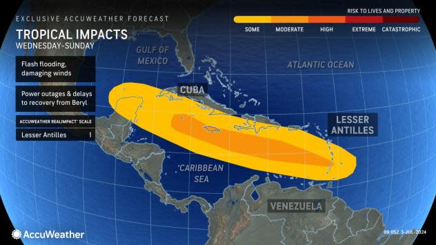
AccuWeather meteorologists are projecting that the system will cross the Windward Islands Wednesday night with the intensity of a tropical rainstorm or perhaps a tropical depression. Even if the system remains relatively weak compared to powerful Beryl, recent damage or destruction of infrastructure on some of the Windward Islands could make impacts worse.
 |
The AccuWeather RealImpact™ Scale for Hurricanes in the Lesser Antilles is a 1 for the upcoming storm.
Because Beryl has caused considerable damage to buildings and infrastructure, such as water, sewer and electrical services, and likely displaced many people on portions of the Windward Islands, the new system can bring much more damage, dangerous conditions, and disruptions than a mere tropical rainstorm might do without Beryl's wrath. Displaced people could face renewed threats from flash flooding, mudslides and coastal erosion.
 |
Roads and storm drains clogged with debris may flood more easily in the wake of Beryl. Weakened buildings hanging on may be further damaged by rain and gusty winds from the new system. Coastal structures that Beryl damaged may sustain more stress from the new tropical system.
In the hardest-hit communities, it may take many months to years to recover from Beryl, let alone the additional damage caused by the new tropical system. The island's tourism industry could be adversely affected for an extended period. At the very least, the new system and its heavy rain and gusty winds will hamper recovery and cleanup operations.
 |
AccuWeather continues to emphasize that the 2024 Atlantic hurricane season will be super-charged with a well-above-historical average number of tropical storms and hurricanes, as well as many storms that have the potential to rapidly intensify due to exceptionally warm waters, such as Beryl has done. Even the typical 'quiet time' for the Atlantic has been undermined by the Atlantic warmth.
Want next-level safety, ad-free? Unlock advanced, hyperlocal severe weather alerts when you subscribe to Premium+ on the AccuWeather app. AccuWeather Alerts™ are prompted by our expert meteorologists who monitor and analyze dangerous weather risks 24/7 to keep you and your family safer.
