
Fiona 'extremely strong and dangerous' as hurricane watch issued for P.E.I., N.S., N.L.
Hurricane Fiona has the potential to be a severe storm for parts of Eastern Canada this weekend.
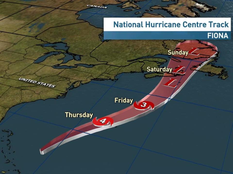
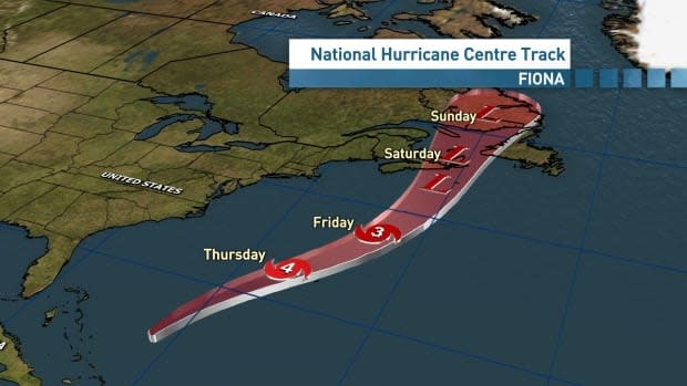
The hurricane will track northward and into the Maritimes late Friday and Saturday as it transitions to a post-tropical storm. That post-tropical transition does not mean the storm will be weaker, but its structure will change. It will grow in scale and cover even more territory.
Bob Robichaud, warning preparedness meteorologist with Environment Canada, said in a briefing Thursday that Hurricane Fiona is an "extremely strong and dangerous storm."
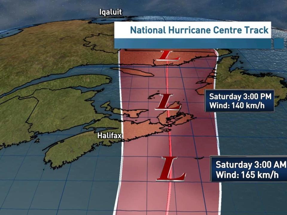
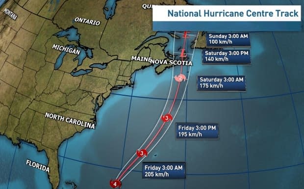
While the "cone of uncertainty" is still quite large, it's narrowing each day. Forecast models continue to project landfall over Cape Breton or the eastern mainland of Nova Scotia.
The storm was about 1,800 kilometres southwest of Halifax with an intensity of 215 km/h as of Thursday afternoon.
While some uncertainty remains with the track and other details, the potential impacts are becoming more clear.
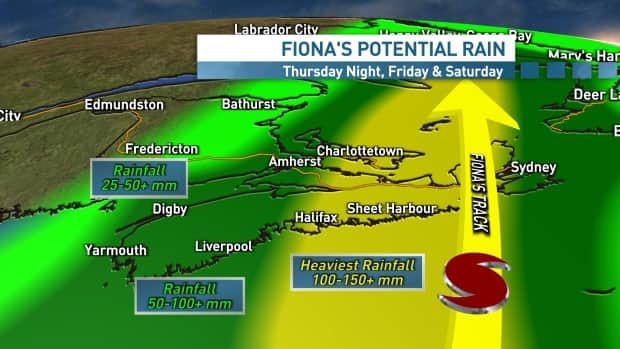
Rain will arrive well ahead of Fiona. A cold front moving in from the west will bring its own rain on through Thursday and into Friday and then begin to tap into moisture from Fiona.
This comes as Environment Canada issued a hurricane watch including all of P.E.I., eastern Nova Scotia including Cape Breton Island, western Newfoundland and Îles-de-la-Madeleine.
A tropical storm watch or statement is also in place for parts of southern Quebec, western Nova Scotia, eastern New Brunswick and much of Newfoundland and Labrador, including the Avalon peninsula.
WATCH | CBC meteorologist Ryan Snoddon's full Fiona forecast
"Every storm is different," Robichaud said.
He added that there are a variety of factors, including if the storm shifts away from its current track, that could affect how hard the region is hit, though Fiona's area of coverage is reminiscent of 2019's Hurricane Dorian.
"Will it be as strong as [Hurricane] Juan when Juan made landfall in 2003 where there were some extreme winds but they were concentrated over a small area?" he said, "This storm is going to be bigger in size compared to what Juan was, but maybe a little stronger than what we saw with Dorian."
WATCH | N.S. officials provide update on storm preparations
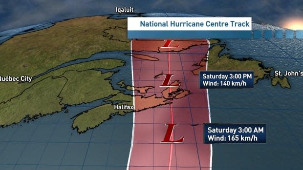
The heaviest rain is expected as Fiona tracks through on Friday night and into Saturday. In the early hours of Saturday, Robichaud said the centre of the storm is expected to track through Cape Breton, but may veer east or west toward central mainland Nova Scotia or western Newfoundland and Labrador.
The prolonged heavy rainfall will bring the potential for flooding, especially along and to the left of the track. Rainfall amounts in those areas could reach 100-150 millimetres and up to 200 millimetres.
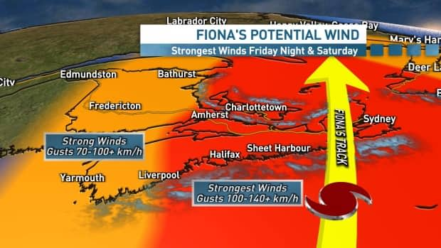
With the storm growing in scale, very strong winds are expected across a large area. With the trees in full leaf, the power outage potential will be high.
"It is expected to slow down substantially as it's making landfall and tracking through the Gulf of St Lawrence. When that happens, given the size of the storm, given that slow, forward motion, that will just prolong some of those stronger winds," Robichaud said.
"It's not going to be a situation where we get two, three hours of very strong winds and then it dies down. We're going to get that, plus an extended period of stronger winds in areas both on the right and the left of the storm."
Widespread gusts of more than 100 km/h are likely across central and eastern Nova Scotia, Cape Breton, P.E.I. and western and southwestern Newfoundland. In these areas, gusts could exceed 130 km/h, especially in exposed coastal areas.
Even in areas further to the west, gusts exceeding 70 km/h look possible.
Storm surge is also likely. The impact will be highly dependent on the track and timing of the storm and how it coincides with high tide. Stay tuned for more details.
Those in the path of the storm should make sure their emergency kit is ready to go and their propane tank is topped up. Check that your downspouts and storm drains are clear and make sure your sump pump and generator are in working order.
WATCH | Hurricane Fiona barrels toward Atlantic Canada
Fire safety during storm
Erica Fleck is the assistant chief of emergency management for Halifax Fire and Emergency.
She told CBC News her crews are preparing for a "major event," including possible storm surges and flooding. She said fallen leaves could clog catch basins, keeping the water on the surface, and the dry ground will take time to absorb it.
Trees could fall and block roads, she added.
She said her staff are prepared to work long hours over the weekend should they be needed. She urged people on well water to prepare in case they lose power and access to that water.
"The biggest danger is flying objects from people who don't secure their objects," she said, listing trampolines, planting pots, toys, bicycles and other outdoor items. She said if you bring a barbecue inside, disconnect the propane, and don't operate anything run by fuel inside your home.
WATCH | Halifax Fire's Erica Fleck on storm preparedness
She also urged people to avoid using candles due to the fire risk.
"The biggest thing is for people to stay inside and stay safe," she said. "If they do have to evacuate, they call 911 and we will evacuate them immediately. We will have emergency shelters open in advance of the storm."
MORE TOP STORIES

