
Tropical rainstorm to bring flooding, impacts to Southeastern US coast


As AccuWeather meteorologists forecasted, a tropical rainstorm brought showers and thunderstorms to the southern Atlantic coast through Friday night.
An organizing cluster of showers and thunderstorms over the Bahamas pushed toward the Georgia, northern Florida and Carolina coast on Friday, making landfall late Friday night.
As of mid-morning on Friday, hurricane hunter aircraft data indicated the system was on the verge of being a tropical storm. Despite this, the storm was not able to develop into a tropical depression or tropical storm.
For an official tropical depression to be declared by the National Hurricane Center, the system must have a closed circulation with winds of 38 miles per hour or less. A tropical storm is one step up from a tropical depression with sustained winds of 39-73 mph.
 |
The AccuWeather RealImpact™ Scale for hurricanes is less than one for this system.
"Regardless of development, this feature will bring building seas, gusty winds and areas of heavy rain and thunderstorms to the southeast U.S. coast," explained AccuWeather Meteorologist Andrew Kienzle.
 |
Rip currents increased in strength and frequency from the east-central coast of Florida to North Carolina as the storm approached the Atlantic coast on Friday.
Portions of central and southern Florida are still experiencing moderate to severe drought, according to the U.S. Drought Monitor. Forecasters say that while the additional showers and thunderstorms expected this weekend may result in localized areas of flash flooding, they may also help to alleviate the drought conditions residents are facing.
 |
Into Friday night, this rainstorm brought a general 1-2 inches of rain from northern Florida to Georgia and the Carolina coasts with a pocket of 2-4 inches of rain just south of Jacksonville, Florida.
While the tropical rainstorm has lost wind intensity and organization, showers and thunderstorms will continue across the Southeast, especially in Florida and along the coast of Georgia this weekend as moisture continues to funnel in from the Atlantic.
"Within the heavier rain bands, localized flash flooding can occur," AccuWeather Senior Meteorologist Alex Sosnowski said, "Most of the rain from this system will fall north of the tropical rainstorm that hit the state late last week, so aside from the localized flood risk, the storm may bring beneficial rain to some locations."
 |
This image captured on Friday morning, June 21, 2024, shows a developing area of low pressure just off the coasts of Georgia and northern Florida. (AccuWeather RealVue™ Satellite) |
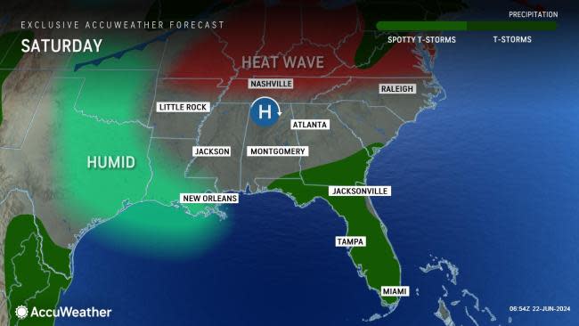
Temperatures across the Southeast generally ranged from the 80s to mid-90s Fahrenheit to end the workweek. By this weekend, widespread highs in the 90s are projected to expand even more across the Gulf Coast states and South.
Cities in Florida, such as Jacksonville and Orlando, will be among some locations where temperatures will creep into the 90s this weekend. However, this is not entirely out of the ordinary, as temperatures in the lower 90s are typical for mid-June for this area of the country.
 |
By early next week, daytime highs in the 90s will continue to be the norm for locations across the Southeast. Any rain and tropical moisture that may push inland could help to provide brief relief from the heat for residents in the area.
Want next-level safety, ad-free? Unlock advanced, hyperlocal severe weather alerts when you subscribe to Premium+ on the AccuWeather app. AccuWeather Alerts™ are prompted by our expert meteorologists who monitor and analyze dangerous weather risks 24/7 to keep you and your family safer.
