
New map for Ottawa city council 2022 favoured by consultants

Independent consultants are recommending Ottawa city council grow by one member in the next municipal vote in 2022, but the final electoral map they propose no longer redraws wards dramatically the way earlier controversial options did.
Ottawa's electoral map needs to redistribute populations because some wards were simply growing so quickly that their residents' votes had become diluted — notably Barrhaven, Gloucester-South Nepean and the growing suburban area of Cumberland ward.
The consultants started work nearly a year ago, but the first five maps they produced seemed to please few. Council had set the goal to stay the same size, at 23 seats, but doing so while adjusting for growing populations meant the shapes of wards needed to change extensively.
Despite some councillors' objections that politicians shouldn't meddle in drawing electoral lines, council voted in July to ask consultants to draw up a sixth option.
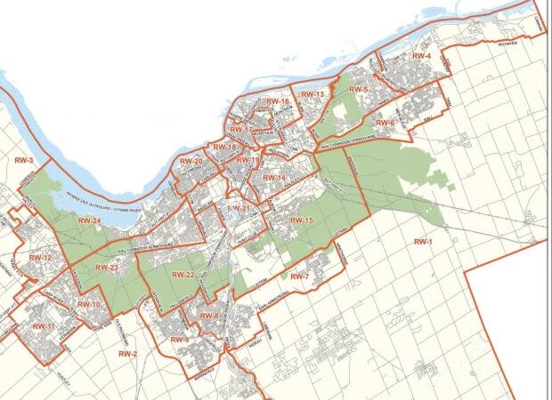
They have now carved up the city into 24 wards instead of 23: 12 inside the Greenbelt, nine in the suburbs, and three rural wards.
If approved, one of the biggest changes would see Barrhaven and Riverside South represented by three councillors instead of two.
Two rural wards would also merge, creating the physically largest ward, stretching from Osgoode in the south to Wilhaven Road in the city's north-east. After residents opposed folding rural Cumberland into its southern neighbour, however, consultants tweaked the area along Highway 174 so that Cumberland Village would join with urban Orléans.
Kanata South weighs in
Linda Dunn still doesn't think the map goes far enough, and leaves rural, French-speaking rural residents and the eastern villages of Sarsfield and Navan aligned with communities they've never belonged to, in a "gigantic" ward.
"It's going to take an hour to drive from one end ot the other," said Dunn, a former councillor in what was then Cumberland Township, who drew east-end residents' attention to the ward boundary changes this past fall. "I don't know how any one person is going to manage that. It's a recipe for disaster."
Coun. Matthew Luloff agrees the map isn't perfect, but is glad Cumberland Village, at least, has been brought into Orleans' fold.
Luloff is also glad many wards are now outlined by natural boundaries such as Bilberry Creek or Innes Road — helping residents know which councillor to call with an issue — rather than arbitrarily splitting neighbourhoods such as Queenswood Heights and Fallingbrook.
"I'm really pleased to see the consultants took a long hard look and kept those neighbourhoods together. I think that it makes a really big difference," he said.

Kanata residents also seemed to take great interest in the ward boundary changes. Half of the 2,150 surveys that came in this fall were from residents in Kanata South.
Their councillor, Allan Hubley, had been frustrated this past summer that all options had used Terry Fox Drive rather than the Carp River as the dividing line, putting the Kanata Recreation Centre and Walter Baker Park into Stittsville. In the final proposed map, those amenities remain in Kanata South and the river remains the boundary.
Consultants aimed for the average population to be 47,900 per ward by 2026, although rural wards will remain below average.
The recommended new ward boundaries go to finance committee Tuesday for approval, then on to city council Dec. 9.

