
Mapped: Hurricane Beryl powers through Caribbean islands as Category 4 storm
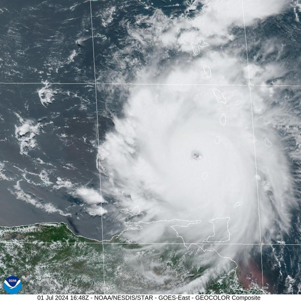
Hurricane Beryl is barreling towards Jamaica as a Category 4 storm after making landfall in the Windward Islands, bringing devastating winds and storm surges that have destroyed homes, wiped out power, and left at least seven people dead.
The storm continues to beat records, first becoming the earliest Category 4 hurricane and later the earliest Category 5 hurricane in the Atlantic.
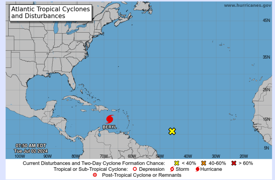
On Tuesday, Beryl was again downgraded to Category 4 with 155mph winds.
Beryl charted a deadly path through Grenada and St Vincent and the Grenadines, destroying buildings and killing at least seven, including three in Venezuela where outer rings of the hurricane caused heavy rainfall.
Officials received “widespread reports of destruction and devastation in Carriacou and Petite Martinique”, Grenada prime minister Dickon Mitchell said. “In half an hour, Carriacou was flattened.”
One person was killed in Grenada’s capital St George’s, when a tree fell on a house.
“We do hope there aren’t any other fatalities or any injuries,” said Mitchell. “But bear in mind the challenge we have in Carriacou and Petite Martinique.”

Authorities have not yet been able to assess the situation on the islands of Carriacou and Petite Martinique, where there were initial reports of major damage but communications were largely down, he said.
On the Grenadine island Union Island, around 90 per cent of homes have been damaged or destroyed, he said.
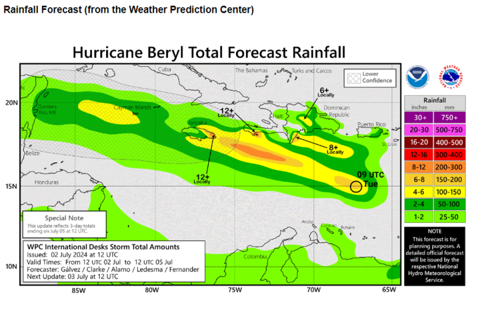
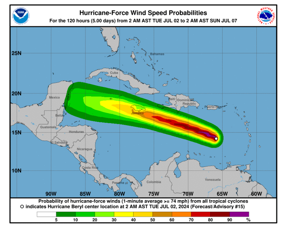
The Category 4 storm will bring up to three feet of storm surge to Hispaniola on Wednesday.
Beryl is now only the second storm on record to reach the intensity of Category 5 in July, after Emily did so in mid-July 2005.
Earlier on Sunday, it became the earliest storm to reach Category 4 and the first ever to do so in June.
The hurricane was downgraded Sunday evening to a Category 3, but picked up power and speed over warm ocean water and was upgraded to Category 4 on Monday morning.
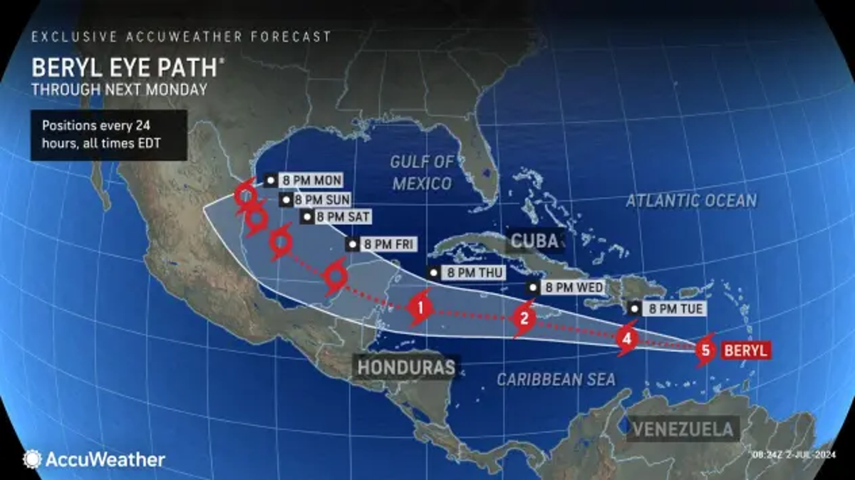
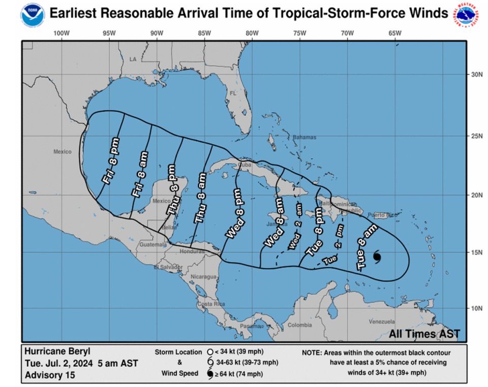
“Fluctuations in strength are likely during the next day or so, but Beryl is expected to still be near major hurricane intensity as it moves into the central Caribbean and passes near Jamaica on Wednesday,” the NHC said.
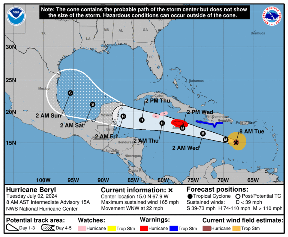
The hurricane will continue to move toward Jamaica, reaching near the island on Wednesday. Even if Beryl doesn’t make direct landfall in Jamaica, it will be close enough to heavy rainfall and wind gusts.
Earlier on Monday,the NHC urged residents across the Caribbean islands to listen to their local governments and emergency management teams for any preparedness and/or evacuation orders.
With the hurricane hitting St Vincent and the Grenadines over the carnival weekend, prime minister Ralph Gonsalves on Sunday urged residents to postpone their festivities and prepare for Beryl to hit.
Mr Gonsalves has already ordered the early closure of bars and postponed some carnival events, according to Loop News.
Airports were also shuttered including in Barbados, Grenada, and St Lucia on Sunday night in preparation for the storm, however, Grenada’s Maurice Bishop International Airport reopened on Tuesday.
The storm is expected to remain a major hurricane as it moves through the Caribbean, with a Tropical Storm watch in effect for the south coast of Hispaniola and a Hurricane Warning issued for Jamaica, as hurricane conditions are possible on Wednesday.
A Hurricane Watch is in effect on Tuesday for Grand Cayman, Little Cayman and Cayman Brac, as Beryl is forecast to pass near the Cayman Islands on Thursday.
A computer model of Hurricane Beryl’s many possible paths, known as a “spaghetti” model, showed the direction the destructive storm could take as it moved towards the southeastern US in bathtub-warm waters of the Gulf of Mexico.
The model showed the storm potentially blowing into the Gulf Coast, near eastern Texas and Louisiana.
Global heating, caused by burning coal, oil and gas, has been increasing temperatures on land and the ocean. Warmer ocean waters fuel hurricanes. The area where Beryl is located, ocean temperatures are 2 to 3 degrees above normal for this time of the year, the levels that aren’t typically seen until September.

