
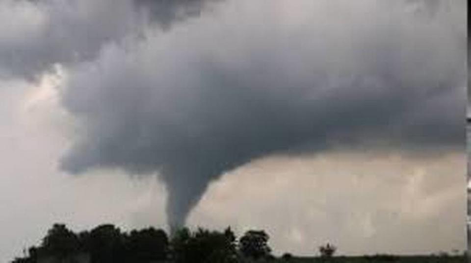
Tornado watch issued for southwestern Illinois as region braces for thunderstorms
The metro-east can expect a double dose of severe weather Friday afternoon, according to a meteorologist with the National Weather Service of St. Louis.
The first wave likely will come through around 3-4 p.m. with the second around around 6-7 p.m. while being completely out of the area by 9 or 10 p.m. Matt Beitscher with the National Weather Service said all potential threats are on the table during both rounds of storms, including tornadoes.
The National Weather Service has also issued a tornado watch for the metro-east until 8 p.m. Friday.
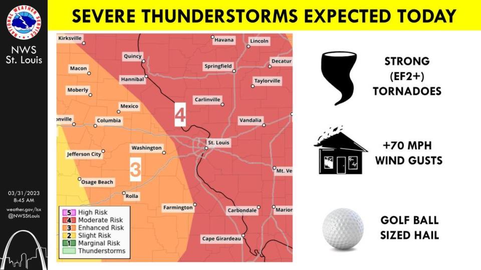
“We’re still expecting severe weather to impact the region in multiple waves,” he said Friday morning. “We could see large hail 2 inches or greater in diameter and damaging winds in excess of 70 miles per hour. And we’re certainly concerned with the formation of tornadoes. These are tornadoes that, if they develop, could be longer in duration and as strong as an EF-2.”
Beitscher said the tornado risk is the same for both waves.
“There’s no difference between the two to where one has a higher potential than the other,” he said. “We’re asking folks to be on a heightened alert until these storms pass completely. It’s such a volatile situation to where we want to make sure people aren’t caught off guard because it’s not raining. And then we’ll let people know on social media when it’s all clear.”
Beitscher also encouraged people to report any potential tornado development to the National Weather Service, if feasible.
“If you see a funnel cloud or a wall cloud — which is the lowering of a cloud that’s rotating — these are factors that play into a tornado,” he said. “Please report that to the NWS. The best way to be aware of tornadic activity is to have multiple ways to receive warnings. Make sure your cell phone has wireless emergency alerts available and enabled. Try to follow broadcast media. Follow us on social media. We publish any warnings and updates frequently.
“If you have a NOAA (National Oceanic and Atmospheric Administration) weather radio, that’s an excellent resources. Make sure to keep it on. And some of this threat may occur after the dark and people may not be able to see some of those things developing. So it’s important you tune into those trusted weather sources.”
All in all, potential rainfall is only a minor concern, while people can expect power outages.
“These storms will be moving at such a high rate of speed, we’re not going to get too much over one area,” Beitscher said. “We’re not expecting everyone to see severe weather ... some people may see next to nothing and others could see all the severe weather that goes with these thunderstorms. On the higher end, people may get an inch of rain. But it’s not going to cause any flooding.”
Beitscher strongly encouraged people to have their plan in place immediately.
“We’re asking folks, certainly, to stay updated with the forecast. It’s extremely important This will evolve quickly. Make sure to have trusted ways to get verifiable updates from the National Weather Service and local media. Be prepared to take action when warranted. Start preparing right now if you haven’t already. And act on those preparations when a warning is issued,” he said.
Safety tips
Jared Maples, another National Weather Service meteorologist, offered related safety tips, especially for people without basements. He uggested having a plan in place before the storm to take up shelter with a nearby neighbor or family member who does have a basement.
“Talk to neighbors you might have a rapport with or family or friends and try to get a plan set in place before the event comes,” Maples said Thursday. “Say to them, ‘If I need shelter can I come to your place and seek shelter and spend time at your house while the storms go through?’ The first step is to get agreement. Then, keep an eye on the weather and updates and a best estimate of when things will impact your location within a couple hours. Keep an eye on the warnings and watches.
“That way when it starts to bear down, you can make a quick decision. If you’re driving to get shelter, just spend a few hours at that person’s location. That way you don’t have to make that decision and be in a car and in a worse spot out in it rather than already being in a safe structure.”
Additional suggestion, final piece of advice
For people who do not have this option, Maples offered these tips.
“If you can’t get to someone else’s home, then determine the innermost portion of the house such as a hallway closet or a bathroom. These are typically smaller rooms usually enclosed with strong structural materials,” Maples said. “That compact caging often is what helps keep that enclosure in one piece.
“Bathtubs are a huge advantage because they’re basically a shell. Put a mattress or soft pillows over you to shield yourself from outside debris hitting you.”
Whatever a person’s disposition, Maples strongly recommended being proactive instead of reactive.
“Some people may think having a plan in place is overblown. However, talk to people who maybe thought it was overblown in the beginning but had that plan in place to where it was second nature ... instead of having to think about it and not having those extra seconds which could be the difference between being injured or killed.”
As Beitscher noted, the National Weather Service recommends keeping plugged into the forecast as it develops at www.weather.gov. Their Facebook page is www.facebook.com/NWSStLouis.

