
Multi-day storm threat looms as low pressure system takes aim at Ontario
A low-pressure system has been traversing Canada this week and is now moving onto a new target: Ontario. Severe storms will sweep the Great Lakes over the next two days, bringing impactful weather to the north Wednesday and the south on Thursday.
DON'T MISS: Three tornadoes confirmed from Thursday’s storms in Ontario, Quebec
Wednesday
Areas: Northwestern Ontario, southeastern Manitoba
Timing: Afternoon and evening hours
Weather: Northwestern Ontario will be first up to see the threat, bearing severe thunderstorm activity through Wednesday with widespread hazards.

The low will sink south, bringing the risk for severe storms closer to the U.S. border with most cells staying south of the Trans-Canada Highway. The main threat with these storms will be strong wind gusts and large hail. A chance of rotation within the storms that develop, but the risk is higher stateside.
RELATED: When extreme weather hits, trauma is the invisible damage
Confidence: High for severe thunderstorms boarding the United States, low for tornadic activity
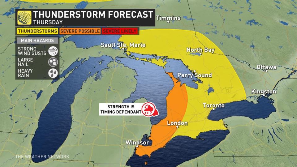
Thursday
Areas: Southwestern Ontario
Timing: Afternoon and evening hours
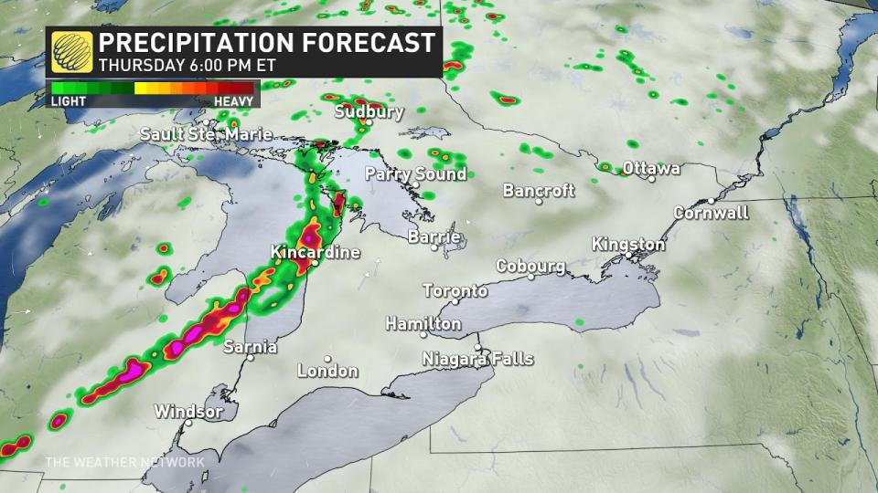
Weather: Southwestern Ontario should gear up for an active weather day Thursday. The potent low barrels across the Great Lakes, and early signals spell a chance for impactful dinner-hour storms along Lake Huron and Georgian Bay shores.
As the storms come ashore there is the chance for them to bring the risk of strong wind gusts & large hail, nickel to quarter size. The severity could increase or decrease depending on the speed of the system, be sure to check back for updates.
Friday
Areas: Eastern Ontario and southern Quebec
Timing: Friday afternoon - evening
Weather: The same low that will bring storms across southwestern Ontario will head northeast, bringing the risk of storms to eastern Ontario and southern Quebec. There is a risk that these storms could become severe in nature, so be sure to check back for updates as move closer to this event.
Prepare
Keep The Weather Network’s app handy on your phone to peek at the radar and keep up with watches and warnings as the day progresses.
Stay close to a safe shelter in case storms threaten your location. And remember, the greatest danger in any thunderstorm is lightning. If you can hear thunder, you’re close enough to be struck by lightning.
Thumbnail courtesy of Kyler, taken in Richmond, Ont.
Stay tuned to The Weather Network for the latest updates on conditions across Ontario.

