
Ontario snaps right into winter with plunging temperatures, rounds of snow
From 20-degree daytime high temperatures and early November short wearing weather -- to a quick tumble into icy December-like feels and rounds of snow with challenging driving conditions. There was no easy transition from fall into winter across much of Ontario over the last few days. While the lake-effect snow squalls will wind down through the day on Monday, another round is possible by Wednesday with a reinforcing shot of Arctic air. There's also the potential for the first widespread coating of snow across the region, though accumulations will be highly impacted elevation and location. See what you'll need to prepare for this week, below.
DON'T MISS: Icy weather is inevitable. Here's what you need to prepare
This week: More snow amid reinforcing shot of Arctic air
After a weekend that saw the first multi-day snow squall even across southern Ontario, widespread below seasonal conditions are set to dominate this week and beyond, with another reinforcing shot of Arctic air and temperatures more typical of early December at times.
Walking in a wintry wonderland ❄️. The snow has finally made it to Orillia. Big snowflakes, too. Roads are slippery. Be careful when travelling this evening. @weathernetwork @cityoforillia #ONstorm #ONwx #SeeSnowGoSlow pic.twitter.com/NUSU2iWZXd
Walking in a wintry wonderland ❄️. The snow has finally made it to Orillia. Big snowflakes, too. Roads are slippery. Be careful when travelling this evening. Nathan Howes TWN on Twitter: "Walking in a wintry wonderland ❄️. The snow has finally made it to Orillia. Big snowflakes, too. Roads are slippery. Be careful when travelling this evening. @weathernetwork @cityoforillia #ONstorm #ONwx #SeeSnowGoSlow pic.twitter.com/NUSU2iWZXd / Twitter" Nathan Howes TWN on Twitter: "Walking in a wintry wonderland ❄️. The snow has finally made it to Orillia. Big snowflakes, too. Roads are slippery. Be careful when travelling this evening. @weathernetwork @cityoforillia #ONstorm #ONwx #SeeSnowGoSlow pic.twitter.com/NUSU2iWZXd / Twitter" Nathan Howes TWN on Twitter: "Walking in a wintry wonderland ❄️. The snow has finally made it to Orillia. Big snowflakes, too. Roads are slippery. Be careful when travelling this evening. @weathernetwork @cityoforillia #ONstorm #ONwx #SeeSnowGoSlow pic.twitter.com/NUSU2iWZXd / Twitter" Nathan Howes TWN on Twitter: "Walking in a wintry wonderland ❄️. The snow has finally made it to Orillia. Big snowflakes, too. Roads are slippery. Be careful when travelling this evening. @weathernetwork @cityoforillia #ONstorm #ONwx #SeeSnowGoSlow pic.twitter.com/NUSU2iWZXd / Twitter" Nathan Howes TWN on Twitter: "Walking in a wintry wonderland ❄️. The snow has finally made it to Orillia. Big snowflakes, too. Roads are slippery. Be careful when travelling this evening. @weathernetwork @cityoforillia #ONstorm #ONwx #SeeSnowGoSlow pic.twitter.com/NUSU2iWZXd / Twitter" Nathan Howes TWN on Twitter: "Walking in a wintry wonderland ❄️. The snow has finally made it to Orillia. Big snowflakes, too. Roads are slippery. Be careful when travelling this evening. @weathernetwork @cityoforillia #ONstorm #ONwx #SeeSnowGoSlow pic.twitter.com/NUSU2iWZXd / Twitter"
— Nathan Howes TWN (@HowesNathan) Nathan Howes TWN on Twitter: "Walking in a wintry wonderland ❄️. The snow has finally made it to Orillia. Big snowflakes, too. Roads are slippery. Be careful when travelling this evening. @weathernetwork @cityoforillia #ONstorm #ONwx #SeeSnowGoSlow pic.twitter.com/NUSU2iWZXd / Twitter"
Some images of a snowy Stayner, Ontario after today's snowsqualls off of Georgian Bay had blown through town. #ONStorm pic.twitter.com/lxaWXu8Bsf
Some images of a snowy Stayner, Ontario after today's snowsqualls off of Georgian Bay had blown through town. Michael Donly on Twitter: "Some images of a snowy Stayner, Ontario after today's snowsqualls off of Georgian Bay had blown through town. #ONStorm pic.twitter.com/lxaWXu8Bsf / Twitter" Michael Donly on Twitter: "Some images of a snowy Stayner, Ontario after today's snowsqualls off of Georgian Bay had blown through town. #ONStorm pic.twitter.com/lxaWXu8Bsf / Twitter"
— Michael Donly (@MythicalMD) Michael Donly on Twitter: "Some images of a snowy Stayner, Ontario after today's snowsqualls off of Georgian Bay had blown through town. #ONStorm pic.twitter.com/lxaWXu8Bsf / Twitter"
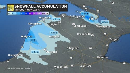
Road conditions began to deteriorate through Sunday, with locally heavy flurries and snow squalls off of Lake Huron and Georgian Bay. In some of the hardest hit areas, as much as 30 cm was forecast to hit, with local snowfall rates of 2-4 cm per hour at times.
On Monday, after some additional accumulations, snow squall activity will begin to taper off in the traditional snow belts due to a change in wind direction, easing through the afternoon and completely gone by the evening.
WATCH: These snow squalls gave southern Ontario its first wintry weekend
Temperatures will remain stubbornly below seasonal, however, and the next round of snow won't be too far off either.
On Tuesday, winds out of the northeast will result in bands of wet snow targetting cities like Oakville, Burlington, and even downtown Toronto.

Snow from a low pressure system will then spread across southern Ontario on Tuesday night and linger through early Wednesday.
It will be the first widespread wet snow threat for the Greater Toronto Area (GTA) this season, including the first snowfall for Montreal later on Wednesday. Typical of mid-November events, temperatures will be marginal with accumulations highly impacted by elevation and distance from the Great Lakes.
Most locations are facing up a few centimetres of snowfall, with some communities recording locally higher amounts of 5-10 cm.
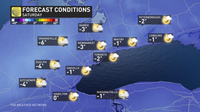
Cold and blustery conditions will end the week, with another round of lake-effect snow in the snow belts. Temperatures on Friday and Saturday will be more typical of early to mid December.
Be sure to check back for the latest weather updates across Ontario.

