
PHOTOS: Idalia weakens after a destructive path through southeastern U.S.

Visit The Weather Network's hurricane hub to keep up with the latest on tropical developments in Canada and around the world
Hurricane Idalia officially made landfall Wednesday morning in the Big Bend region near Keaton Beach.
Idalia, now a tropical storm, is travelling across South Carolina and lashing the state with heavy rain and sustained winds of near 110 km/h, and even higher gusts.
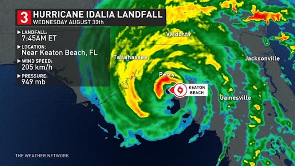
The National Hurricane Center confirmed Idalia made landfall as a Category 3 hurricane at 7:45 a.m.
Idalia is the strongest storm to hit the Big Bend region in more than 125 years and the third hurricane to make landfall in Florida in the past 12 months, following Hurricane Ian in September 2022 and Hurricane Nicole in October 2022.

As of 6:15 p.m. EDT, there are around 20,000 Floridians without power according to poweroutage.us. The majority of the outages are around the Big Bend region of the state.
The Weather Network's Mark Robinson was in Perry, Fla., capturing early impacts from the hurricane.
Looking down into the town of Steinhatchee. This area took a heavy hit from storm surge. @weathernetwork @jwhittalTWN pic.twitter.com/p22PG2GXH4
Looking down into the town of Steinhatchee. This area took a heavy hit from storm surge. Mark Robinson on Twitter: "Looking down into the town of Steinhatchee. This area took a heavy hit from storm surge. @weathernetwork @jwhittalTWN pic.twitter.com/p22PG2GXH4 / Twitter" Mark Robinson on Twitter: "Looking down into the town of Steinhatchee. This area took a heavy hit from storm surge. @weathernetwork @jwhittalTWN pic.twitter.com/p22PG2GXH4 / Twitter" Mark Robinson on Twitter: "Looking down into the town of Steinhatchee. This area took a heavy hit from storm surge. @weathernetwork @jwhittalTWN pic.twitter.com/p22PG2GXH4 / Twitter"
— Mark Robinson (@StormhunterTWN) Mark Robinson on Twitter: "Looking down into the town of Steinhatchee. This area took a heavy hit from storm surge. @weathernetwork @jwhittalTWN pic.twitter.com/p22PG2GXH4 / Twitter"
Cleanup begins here in Perry, Florida. @weathernetwork @jwhittalTWN #IDALIAhurricane #Idalia pic.twitter.com/3jZRFsBl2A
Cleanup begins here in Perry, Florida. Mark Robinson on Twitter: "Cleanup begins here in Perry, Florida. @weathernetwork @jwhittalTWN #IDALIAhurricane #Idalia pic.twitter.com/3jZRFsBl2A / Twitter" Mark Robinson on Twitter: "Cleanup begins here in Perry, Florida. @weathernetwork @jwhittalTWN #IDALIAhurricane #Idalia pic.twitter.com/3jZRFsBl2A / Twitter" Mark Robinson on Twitter: "Cleanup begins here in Perry, Florida. @weathernetwork @jwhittalTWN #IDALIAhurricane #Idalia pic.twitter.com/3jZRFsBl2A / Twitter" Mark Robinson on Twitter: "Cleanup begins here in Perry, Florida. @weathernetwork @jwhittalTWN #IDALIAhurricane #Idalia pic.twitter.com/3jZRFsBl2A / Twitter" Mark Robinson on Twitter: "Cleanup begins here in Perry, Florida. @weathernetwork @jwhittalTWN #IDALIAhurricane #Idalia pic.twitter.com/3jZRFsBl2A / Twitter"
— Mark Robinson (@StormhunterTWN) Mark Robinson on Twitter: "Cleanup begins here in Perry, Florida. @weathernetwork @jwhittalTWN #IDALIAhurricane #Idalia pic.twitter.com/3jZRFsBl2A / Twitter"
Braving hurricane #Idalia and flying garbage cans is all in a day's work for @StormhunterTWN as he reports live from Florida. #FLwx pic.twitter.com/cocxz6oXlQ
Braving hurricane The Weather Network on Twitter: "Braving hurricane #Idalia and flying garbage cans is all in a day's work for @StormhunterTWN as he reports live from Florida. #FLwx pic.twitter.com/cocxz6oXlQ / Twitter" and flying garbage cans is all in a day's work for The Weather Network on Twitter: "Braving hurricane #Idalia and flying garbage cans is all in a day's work for @StormhunterTWN as he reports live from Florida. #FLwx pic.twitter.com/cocxz6oXlQ / Twitter" as he reports live from Florida. The Weather Network on Twitter: "Braving hurricane #Idalia and flying garbage cans is all in a day's work for @StormhunterTWN as he reports live from Florida. #FLwx pic.twitter.com/cocxz6oXlQ / Twitter" The Weather Network on Twitter: "Braving hurricane #Idalia and flying garbage cans is all in a day's work for @StormhunterTWN as he reports live from Florida. #FLwx pic.twitter.com/cocxz6oXlQ / Twitter"
— The Weather Network (@weathernetwork) The Weather Network on Twitter: "Braving hurricane #Idalia and flying garbage cans is all in a day's work for @StormhunterTWN as he reports live from Florida. #FLwx pic.twitter.com/cocxz6oXlQ / Twitter"
Major power flashes ongoing in Perry. @weathernetwork #IDALIAhurricane @jwhittalTWN pic.twitter.com/4Cobwc3hW5
Major power flashes ongoing in Perry. Mark Robinson on Twitter: "Major power flashes ongoing in Perry. @weathernetwork #IDALIAhurricane @jwhittalTWN pic.twitter.com/4Cobwc3hW5 / Twitter" Mark Robinson on Twitter: "Major power flashes ongoing in Perry. @weathernetwork #IDALIAhurricane @jwhittalTWN pic.twitter.com/4Cobwc3hW5 / Twitter" Mark Robinson on Twitter: "Major power flashes ongoing in Perry. @weathernetwork #IDALIAhurricane @jwhittalTWN pic.twitter.com/4Cobwc3hW5 / Twitter" Mark Robinson on Twitter: "Major power flashes ongoing in Perry. @weathernetwork #IDALIAhurricane @jwhittalTWN pic.twitter.com/4Cobwc3hW5 / Twitter"
— Mark Robinson (@StormhunterTWN) Mark Robinson on Twitter: "Major power flashes ongoing in Perry. @weathernetwork #IDALIAhurricane @jwhittalTWN pic.twitter.com/4Cobwc3hW5 / Twitter"
Content shared on social media further demonstrates the severity of this storm:
Western eyewall near Perry, FL was no joke! Things are starting to calm down a bit here thankfully. #IDALIA #FLwx @spann pic.twitter.com/PujTGz42Nb
Western eyewall near Perry, FL was no joke! Things are starting to calm down a bit here thankfully. Andrew Colantoni 🚀 on Twitter: "Western eyewall near Perry, FL was no joke! Things are starting to calm down a bit here thankfully. #IDALIA #FLwx @spann pic.twitter.com/PujTGz42Nb / Twitter" Andrew Colantoni 🚀 on Twitter: "Western eyewall near Perry, FL was no joke! Things are starting to calm down a bit here thankfully. #IDALIA #FLwx @spann pic.twitter.com/PujTGz42Nb / Twitter" Andrew Colantoni 🚀 on Twitter: "Western eyewall near Perry, FL was no joke! Things are starting to calm down a bit here thankfully. #IDALIA #FLwx @spann pic.twitter.com/PujTGz42Nb / Twitter" Andrew Colantoni 🚀 on Twitter: "Western eyewall near Perry, FL was no joke! Things are starting to calm down a bit here thankfully. #IDALIA #FLwx @spann pic.twitter.com/PujTGz42Nb / Twitter"
— Andrew Colantoni 🚀 (@acolan1006) Andrew Colantoni 🚀 on Twitter: "Western eyewall near Perry, FL was no joke! Things are starting to calm down a bit here thankfully. #IDALIA #FLwx @spann pic.twitter.com/PujTGz42Nb / Twitter"
The home with roof removed on Keaton Beach. #FLwx #HurricaneIdalia pic.twitter.com/VvJgzkhsUc
The home with roof removed on Keaton Beach. Brian Emfinger on Twitter: "The home with roof removed on Keaton Beach. #FLwx #HurricaneIdalia pic.twitter.com/VvJgzkhsUc / Twitter" Brian Emfinger on Twitter: "The home with roof removed on Keaton Beach. #FLwx #HurricaneIdalia pic.twitter.com/VvJgzkhsUc / Twitter" Brian Emfinger on Twitter: "The home with roof removed on Keaton Beach. #FLwx #HurricaneIdalia pic.twitter.com/VvJgzkhsUc / Twitter"
— Brian Emfinger (@brianemfinger) Brian Emfinger on Twitter: "The home with roof removed on Keaton Beach. #FLwx #HurricaneIdalia pic.twitter.com/VvJgzkhsUc / Twitter"
A lot of structure and tree damage in Perry, FL #Idalia #FLwx pic.twitter.com/C8VznpteaQ
A lot of structure and tree damage in Perry, FL Aaron Rigsby on Twitter: "A lot of structure and tree damage in Perry, FL #Idalia #FLwx pic.twitter.com/C8VznpteaQ / Twitter" Aaron Rigsby on Twitter: "A lot of structure and tree damage in Perry, FL #Idalia #FLwx pic.twitter.com/C8VznpteaQ / Twitter" Aaron Rigsby on Twitter: "A lot of structure and tree damage in Perry, FL #Idalia #FLwx pic.twitter.com/C8VznpteaQ / Twitter"
— Aaron Rigsby (@AaronRigsbyOSC) Aaron Rigsby on Twitter: "A lot of structure and tree damage in Perry, FL #Idalia #FLwx pic.twitter.com/C8VznpteaQ / Twitter"
With any major storm comes the risk of storm surge, which is a major concern as the landfall coincided with Wednesday’s blue supermoon, meaning high tide will increase water levels.
Incredible #Idalia storm surge 6' and counting here at Cedar Key, FL pic.twitter.com/8MzaHJpWce
Incredible Jim Cantore on Twitter: "Incredible #Idalia storm surge 6' and counting here at Cedar Key, FL pic.twitter.com/8MzaHJpWce / Twitter" storm surge 6’ and counting here at Cedar Key, FL Jim Cantore on Twitter: "Incredible #Idalia storm surge 6' and counting here at Cedar Key, FL pic.twitter.com/8MzaHJpWce / Twitter"
— Jim Cantore (@JimCantore) Jim Cantore on Twitter: "Incredible #Idalia storm surge 6' and counting here at Cedar Key, FL pic.twitter.com/8MzaHJpWce / Twitter"
Keep checking back to The Weather Network for more updates on the 2023 Atlantic hurricane season.
Thumbnail credit: David Hodge, The Weather Network

