
Get ready to hear a lot about La Niña. Here's why it could make hurricane season worse.
You'll be hearing a lot about La Niña in the months ahead if the climate pattern forms (federal scientists expect it will sometime this summer).
It now has a 60% chance of occurring, and experts say it would have an impact on the Atlantic hurricane season and the nation's weather next winter.
The La Niña would replace what has been a historically strong El Niño, forecasters said. "There is a historical tendency for La Niña to follow strong El Niño events," the Climate Prediction Center said in a recent forecast.
What is La Niña?
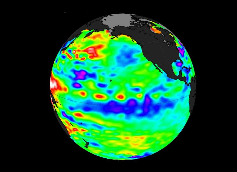
La Niña is a natural climate pattern marked by cooler-than-average seawater in the central and eastern Pacific Ocean. When the water cools at least 0.9 degree Fahrenheit below average for three straight months, a La Niña is declared.
"While this may sound like a small change in temperature, it can cause significant changes in the weather patterns around the globe," said AccuWeather meteorologist Brian Lada.
More: Early forecast says summer 2024 is set to be unusually hot across most of USA
It is one of the main drivers of weather in the United States, especially during the late fall, winter and early spring. It's the opposite to the more well-known El Niño, which occurs when Pacific Ocean water is at least 0.9 degree warmer than average for three months.
The most recent El Niño peaked in December and will go down as one of the five strongest in history, the World Meteorological Organization said.
Can La Niña worsen the Atlantic hurricane season?
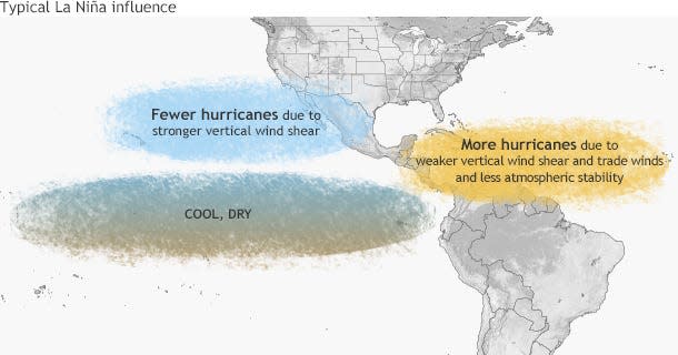
According to the Climate Prediction Center, La Niña can contribute to an increase in Atlantic hurricane activity by weakening the wind shear over the Caribbean Sea and tropical Atlantic basin, which allows storms to develop and intensify.
It's one of the reasons forecasters have predicted a "hyperactive" hurricane season in the Atlantic basin this year, with one forecast expecting as many as 33 named storms. An average year sees 14.
Wind shear refers to the change in wind speed and direction between roughly 5,000 and 35,000 feet above the ground, the National Oceanic and Atmospheric Administration said. Strong vertical wind shear can rip a developing hurricane apart, or even prevent it from forming. This is what can happen in the Atlantic during an El Niño when Atlantic hurricane activity is often suppressed.
While La Niña tends to increase hurricanes in the Atlantic, it also tends to decrease their numbers in the eastern and central Pacific Ocean basins.
What does La Niña mean for weather in the US?
La Niña and El Niño typically have minimal impact on summer weather in the U.S., other than the effect on hurricanes. Winter is the one season when they have the most impact.
A typical La Niña winter in the U.S. brings cold and snow to the Northwest and unusually dry conditions to most of the Southern states, according to the Climate Prediction Center. The Southeast and mid-Atlantic also tend to see higher-than-average temperatures during a La Niña winter.
Meanwhile, New England and the Upper Midwest into New York tend to see lower-than-average temperatures, the Weather Channel said.
This article originally appeared on USA TODAY: La Niña explained: Impact on hurricanes, US weather

