
Red River Floodway and Portage Diversion activated, cutting flood risk in Winnipeg
Manitoba has activated two major flood diversion channels in an effort to cut the flooding risk in Winnipeg.
A piercing siren Friday morning signaled the activation of the Red River Floodway, while the Portage Diversion also began operation around the same time.
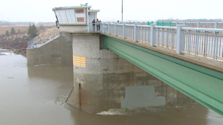
The 47-kilometre-long floodway channel diverts part of the Red River's flow around the east side of Winnipeg, from an inlet near St. Norbert to an outlet near Lockport.
The Portage Diversion is a 29-kilometre channel that starts at an inlet near Portage la Prairie and redirects some water from the Assiniboine River north into Lake Manitoba.
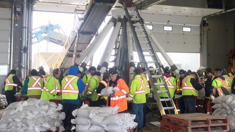
The operation of the channels has already made an impact in Winnipeg, where the need to sandbag some low-lying properties has been reduced.
"City engineers have determined that the number of properties needing sandbag dikes has decreased from 50 to 25. The number of sandbags has been reduced accordingly from 75,000 to 20,000," a news release from the City of Winnipeg stated.
There are already enough sandbags made for those properties that remain at risk but crews will continue making more until the end of Friday as a precaution, in case heavy rains or ice jams cause the river level the rise.
The floodway works by partly damming the river. The control dam gates, which are stored below riverbed level, are raised, restricting the river's flow into the city. The water backs up and the level rises until it flows into the nearby floodway channel.
However, when the river level is rising and before it reaches the floodway gates, it can flood homes in that area. The province has yet to state what the effect will be on Friday.
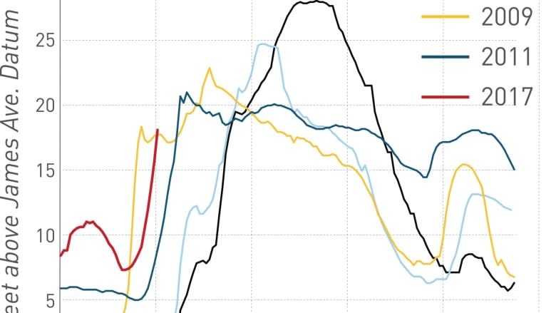
As of Friday afternoon, the Red River level at James Avenue was 18.16 feet (5.53 metres) above normal winter ice levels, a measure commonly referred to as "James."
That's an increase of 2.2 feet since Thursday, but it is not expected to rise too much more now that the flood diversions are being used.
"It is estimated that Red River water levels at James Avenue in Winnipeg will rise to approximately 18.8 feet by Sunday," a news release from the province states.
Since the Red River Floodway was built, most floods in the city have involved river levels just below 20 feet James.
The normal summer level is 6.5 feet James.
The province intends to raise the gates 11 feet, out of a maximum of 40 feet, said Scott Jackson, Manitoba Infrastructure operations manager.
It doesn't happen quickly, though. The two gates are raised centimetres at a time to prevent dangerous currents and waves from being formed.
Winnipeg Mayor Brian Bowman, touring the control structure for the first time, praised the vision of former premier Duff Roblin for the construction of the floodway.
"Seeing it first-hand just makes me appreciate the work that our officials and the provincial officials are doing to keep the city safe," Bowman said.
Conceived after the devastating 1950 flood in Winnipeg, the floodway has since been credited with saving the city 20 times from major floods, most notably in 1979 and 1997.
The natural crest of the Red, south of the city, is expected around April 4.
What is meant by 'James'?
In Winnipeg, river levels are measured by the height, in feet, of the water above normal winter ice levels at the James Avenue pumping station.
The James Avenue location was chosen because it's where the city's main pumping station operated at the time.
- Normal Winter Ice Level — 0 James.
- Normal Summer Level — 6.5 feet James.
- Riverwalk Level — 8.5 feet James.
- 1997 Flood Peak — 24.5 feet James.
- 2005 Flood Peak — 20.1 feet James.
- 2006 Flood Peak — 20.4 feet James.
- 2009 Flood Peak — 22.6 feet James.
SOURCE: City of Winnipeg
