
Relentless rounds of lake-effect snow to bury towns this week
Residents across the Midwest have faced relentless lake-effect snowfall over the last week, and the pattern is not expected to let up anytime soon. Additional snowfall is expected to persist around the Great Lakes through at least the weekend as cold winds blow across the warmer bodies of water.
"The storm that brought heavy snow and bitterly cold air across the Midwest last weekend has created a multiday lake-effect snow event across the typical snow belts over the Great Lakes this week," explained AccuWeather Meteorologist Brandon Buckingham. "With cold air and breezy conditions continuing this week, lake-effect snow will continue to pile up."
 |
Cities such as Grand Rapids, Michigan, have already collected 28.6 inches of snow since the start of the year, with most of that falling between Jan. 8 and Jan. 16. The city has already exceeded its typical amount for the month of 22.6 inches, with additional snow on the way this week.
Other lake-effect hot spots, such as Marquette, Michigan, and Buffalo, New York, have picked up feet of snowfall since the end of the weekend. Marquette has totaled 33 inches of snow so far in January, with the highest daily total climbing to a whopping 18 inches on Jan. 13. Typically, the city records around 42.1 inches of snow during January.
Buffalo International Airport has recorded 31.8 inches of snow so far this month, while nearby locations just south of the city picked up upwards of 3 feet of snow just since the start of the weekend. The hefty snowfall that occurred across the Buffalo metro resulted in the playoff game between Buffalo and Pittsburgh being pushed back from Sunday, Jan. 14 to Monday, Jan. 15.
Footage from the game on Monday afternoon showed numerous dedicated Buffalo and Pittsburgh fans trudging through the snowy stands as the game kicked off, as well as some fans tossing armfuls of snow into the air and sliding down snow mounds as they celebrated Buffalo's 31-17 victory.
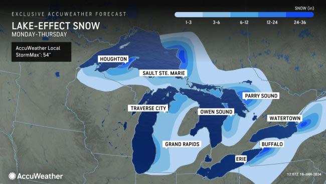
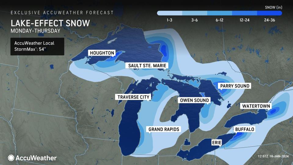
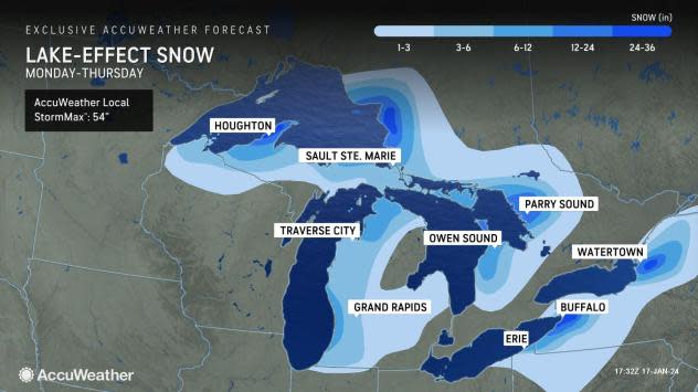
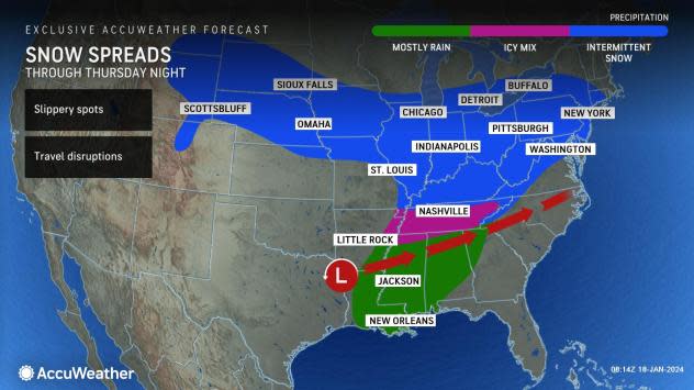
Buffalo and the surrounding suburbs are forecast to total between 2 and 3 feet of snow from Monday to Thursday as snow continues to fall along the lakeshores. Locations farther north around the Tug Hill Plateau can also total a zone of 12-24 inches during the same time frame, with a narrow corridor that could pick up between 24-36 inches of snow. The AccuWeather Local StormMax™ for this lake-effect snow event is 54 inches.
"The most persistent bands through midweek will focus across the northern upper and lower Peninsula of Michigan, as well as western and northern New York downwind of lakes Erie and Ontario. Within these zones, additional accumulations between Tuesday and Thursday morning can pile up over a foot," added Buckingham.
Cold winds and relatively warm lake surfaces will play a large role in the additional surges of lake-effect snow bands through the weekend. This setup can also spark rounds of snow squalls east of the Great Lakes that can rapidly reduce visibility and make travel difficult to impossible. Even narrow bands of snow squalls can make conditions extremely dangerous for travelers, given the frigid temperatures.
 |
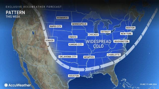
Daytime high temperatures from Wisconsin to western New York ranged from single digits to the low 20s Fahrenheit Wednesday, roughly 10-15 degrees below the historical average for mid-January. The cold air can lead to challenges for road crews in charge of clearing snow.
"With temperatures well below the freezing mark across the region, road crews cannot use salt to clear area roadways because of the low temperatures. Instead, sand is a common alternative to help travelers gain some traction on snow-packed roadways," Buckingham said.
On Wednesday, temperatures in Chicago rose out of the single digits for the first time since Saturday evening, Jan. 13. However, temperatures through the weekend will not be much higher, ranging from 10-25 degrees during the daytime.
This weekend, there will be another chance for accumulating snow and travel disruptions across parts of the Great Lakes.
Buckingham added that a storm between Thursday and Saturday is expected to bring northerly winds that could produce a consolidated lake-effect snow band over Lake Michigan, bringing potentially dangerous travel conditions along Interstate 80 and 94 in northwest Indiana.
 |
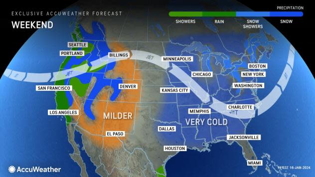
That storm, in two parts, will bring steadier snow from the Midwest to the mid-Atlantic and southern New England zones through Friday night. In the proximity of that storm, the heavier snow bands should ease back over the eastern Great Lakes for a time, but not for long.
Another push of cold air will advance southward across the Central and Eastern states from Friday to Saturday, resulting in daytime temperatures dropping again to 10-25 degrees below historical averages in cities like Chicago, Detroit, Cincinnati and Pittsburgh.
The lake-effect will tend to align in a more northwest-to-southeast fashion with the weekend Arctic air outbreak, bringing heavier snow into other snow belts farther to the east, such as northeastern Ohio, northwestern Pennsylvania and the area near Syracuse, New York. The heaviest snow bands should stay south of the city of Buffalo.
 |
Although residents throughout the Midwest are no strangers to managing the brutally cold winter conditions lingering this week, forecasters say that there is some hope for slightly warmer weather next week. However, the rising temperatures may come at a cost for some locations.
"The extreme cold this week has rapidly accumulated ice on rivers across the Midwest. Looking ahead to next week, a milder and potentially wet pattern could be in store, which could raise river levels and dislodge the ice that has built up. When this occurs, there is always a risk for potential ice jams, which can lead to flooding," explained Buckingham.
Daytime temperatures are expected to rise from the single digits and teens this week to the 30s and 40s beginning early next week. Midwesterners may welcome the improving temperatures following the waves of Arctic air this week, even if they are only temperatures 5-10 degrees above freezing.
Want next-level safety, ad-free? Unlock advanced, hyperlocal severe weather alerts when you subscribe to Premium+ on the AccuWeather app. AccuWeather Alerts™ are prompted by our expert meteorologists who monitor and analyze dangerous weather risks 24/7 to keep you and your family safer.
