
Roads washed out, Telegraph Creek cut off as flood, rainfall warnings persist across B.C.
Large areas of central and northern B.C. remain under flood and rainfall warnings Friday.
B.C.'s River Forecast Centre has issued flood warnings and advisories for the upper Fraser River and its tributaries around Prince George, as well as the Quesnel River.
It says significant rainfall has fallen across the Interior and the northeast, with more "unsettled'' weather in the long-term forecast.
Rapidly rising river levels in headwater areas were expected to continue Friday, with larger rivers rising into the weekend.
Areas under flood watch include the Peace Region, northeastern B.C., the Cariboo, the Chilcotin, the Fraser — from Prince George to Boston Bar, the Liard River basin, as well as the Thompson River and its north and south branches.
Environment Canada has issued rainfall warnings for the northeast portion of the province, particularly around the Peace River region and Fort Nelson.
"Heavy downpours can cause flash floods and water pooling on roads," the weather service advised. "Watch for possible washouts near rivers, creeks and culverts."
CBC meteorologist Brett Soderholm said that even though the heaviest rain has already fallen, water levels are expected to continue to rise right through Sunday.
Major routes closed
Flooding has closed major highways in and out of B.C.
Highway 1 was closed until late Friday morning both east and west of Revelstoke after serious flooding, but has since reopened to single-lane alternating traffic as of Friday afternoon.

Highway 52 north of Tumbler Ridge remained closed Friday afternoon, DriveBC reports.
Highway 16 just east of Jasper, Alta., was inundated following several days of heavy rain. Alberta's provincial highway information service reported that route was opened to single-lane alternating traffic Friday.
DriveBC also warned Friday afternoon of washouts, mudslides and poor road conditions on smaller roads in communities and areas of the B.C. Interior such as Clinton, 100 Mile House, and 70 Mile House.
Many inland ferries are also out of service due to high water, including the Lytton ferry and Big Bar reaction ferry.
Telegraph Creek cut off
The only road link to the remote community of Telegraph Creek in northwestern B.C. was cut off Wednesday, stranding many in the community of about 250 residents.
A torrent of water and debris washed out a section of Telegraph Creek Road when a beaver dam burst high on a mountain flanking the highway.

Rick McLean, Chief of the Tahltan Band Council, told CBC Radio West's Sarah Penton he was among a group of residents stuck on the other side of the slide in Dease Lake overnight, nearly two hours' drive from home.
"You just get into emergency management mode and you start thinking about how we're going to get supplies in and out, who's there, who's vulnerable, who's stuck on this side and how you're going to manage those logistics," McLean said.
McLean said the Telegraph Creek Road is expected to reopen Friday afternoon with the installation of a temporary culvert.
The road remains vulnerable due, in large part, to the after-effects of the wildfire season in 2018. Fires severely damaged the root systems that stabilized the steep slopes on the gravelled highway along the Tahltan and Stikine Rivers.
It is not the first time the isolated community has been cut off by road failure. A landslide on Tahltan Hill closed the road for several weeks in 2019.
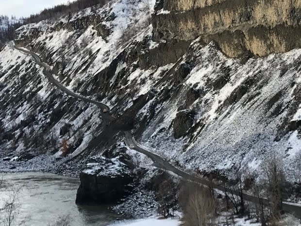
More slides and washouts are expected. Geotechnicians visit every spring to reassess slope stability, McLean said, but there is little that can be done for the damaged root system.
"Time is the cure," he said.
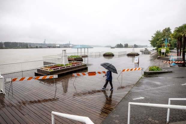
Lower Mainland affected too
Much of B.C. east of the Coast Mountains and north of Kelowna is under some type of warning.
Even in the Lower Mainland, the city of New Westminster announced on Twitter it would close its boardwalk along the Fraser River until water levels recede. It advised caution around riverbanks.
The Cariboo Regional District encouraged residents to have enough food, water, and medications to shelter in place for at least three days should roads or highways close due to flooding or mudslides.

