
Severe storm risk, downpours return to Ontario and Quebec Friday
An active pattern continues across parts of Ontario and Quebec to round out the workweek as an approaching system brings a renewed potential for severe storms and localized flooding.
This is the same system that brought widespread severe weather to southern Ontario during the day Thursday, which caused extensive wind damage and power outages, as well as reports of tennis ball size hail near Essex.
PHOTOS: Hail, damage reported as tornado-warned storms hit southern Ontario
Friday’s storms won’t pack nearly the punch as Thursday’s activity, but strong to severe storms are possible around the National Capital Region and into Metro Montreal. Stay alert for potential watches and warnings on Friday, and have a safety plan if severe weather threatens.
Thursday night into Friday
Areas: Much of southern and eastern Ontario, portions of southern Quebec
Timing: Overnight Thursday into Friday morning

Weather: The vivacious storms that rolled through southern Ontario will continue chugging east into the nighttime hours on Thursday, bringing a risk for strong wind gusts and heavy rainfall as the activity pushes into eastern Ontario.
Expect periods of thunder and heavy rain as the low-pressure system responsible for the stormy conditions heads east toward Ottawa and southern Quebec.
Nocturnal thunderstorms are dangerous in their own right as it’s easy to sleep through potential severe weather warnings, and it’s difficult to see standing water or downed trees while driving at night.
Friday
Areas: Eastern Ontario and southern Quebec
Timing: Through the afternoon and evening hours
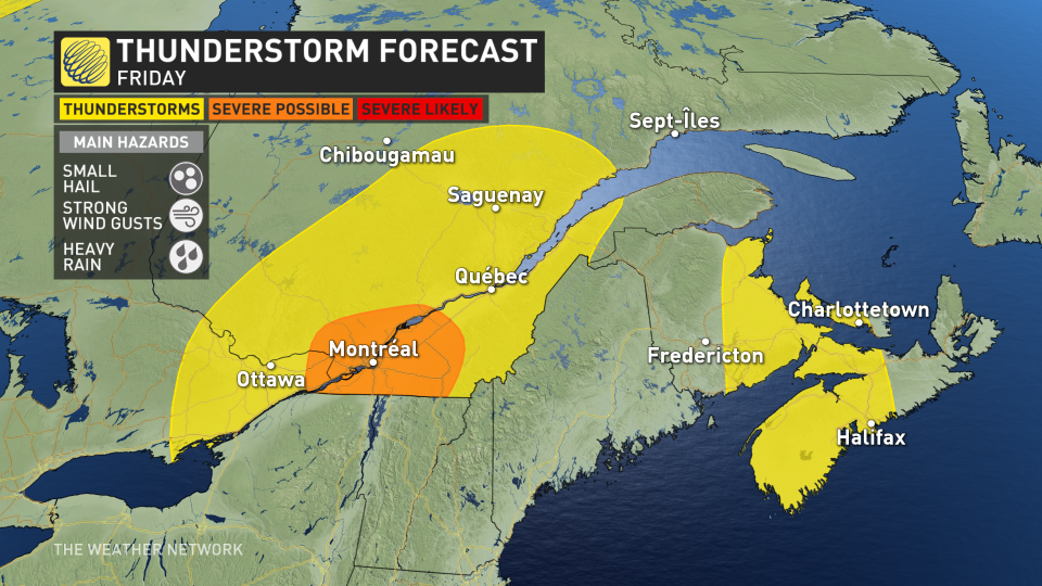
Weather: Friday will see scattered thunderstorms developing over eastern Ontario and southern Quebec through the afternoon and evening hours.
Most of the storms will remain below severe limits, but a few could turn severe around Montreal, the Eastern Townships, and far eastern Ontario.
DON’T MISS: Four simultaneous heat domes break major records across the globe
Any of the feistier thunderstorms could produce small hail, strong wind gusts, and heavy rainfall. Given the heavy rains and flooding of late, the ground is saturated and it wouldn’t take much of a downpour to lead to localized flooding.
Remain mindful of the flooding risk and stay alert while driving. It’s impossible to tell how deep the water is until it’s too late, or even if there’s still a road beneath any standing water. It takes surprisingly little water for a vehicle to lose traction and potentially become stranded in floodwaters.
Prepare
Keep The Weather Network’s app handy on your phone to peek at the radar and keep up with watches and warnings as the day progresses.
Stay close to a safe shelter in case storms threaten your location. And remember, the greatest danger in any thunderstorm is lightning. If you can hear thunder, you’re close enough to be struck by lightning.
Stay tuned to The Weather Network for the latest updates across Ontario and Quebec.

