
Severe thunderstorm, flash flood risk returns to the South

The relative quiet the southern United States has been enjoying much of this week is coming to an abrupt end with the renewal of flooding downpours and severe thunderstorms for the first weekend of February, warn AccuWeather meteorologists.
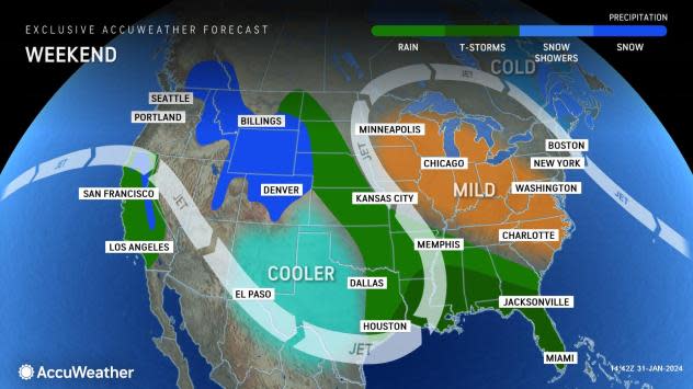
"As a storm works its way east from the southern Plains to the Gulf Coast states into the weekend, it will tap into moisture from the Gulf of Mexico," said AccuWeather Senior Meteorologist Dan Pydynowski. "This will produce a myriad of travel threats across the South."
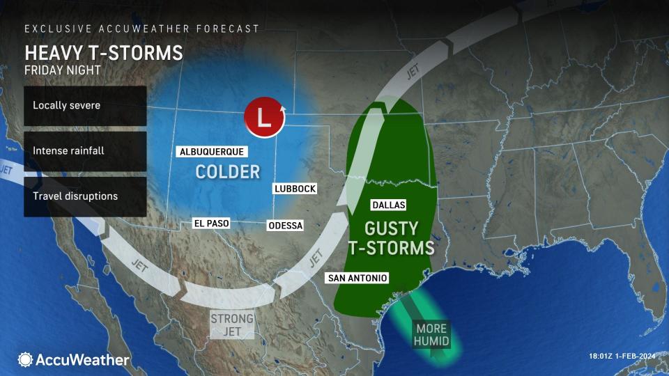
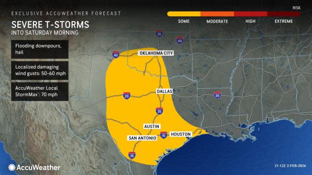
The same storm that brought a firehose of rain, wind and snow into California this week will be the one to impact the South this weekend. It has already crossed Southwest deserts and the Rockies and brought damaging winds, hail and even a tornado to Texas late Friday into Friday night. The storminess and risk of flash flooding is set to expand through the Mississippi Valley and Southeast over the weekend, ending a prolonged stretch of dry weather.
 |
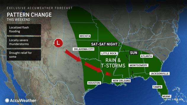
Millions more will have their plans impacted by the weather come Saturday and Sunday farther east, as the storm continues to gather moisture and works into the Mississippi and Tennessee valleys and eventually much of the Southeast, say AccuWeather meteorologists.
"On Saturday, flooding downpours could slow travelers on Interstate 10 heading through Louisiana, and locally heavy rain can extend as far north of the Ozarks, as well," said Pydynowski. Little Rock, Memphis and New Orleans are among the metropolitan areas that will be the wettest to start the weekend.
 |
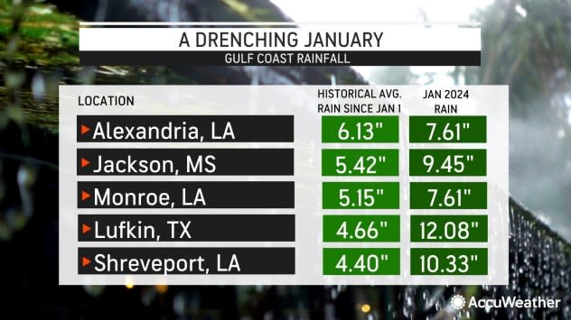
Last week, this region was subject to repeated downpours that resulted in a month's worth of rain in just days, causing flooding that led to water rescues and closed highways in Louisiana. There was also a silver lining; longstanding drought conditions and low water levels on the Mississippi River impacting commerce were being reversed.
Rainfall amounts are not expected to be as heavy this time, with a general 1-3 inches of rain in the forecast, rather than the 5-10 inches experienced in some areas last week. Still, any rain can lead to a renewal of flooding of all types, from poor drainage to streams to even larger stem rivers, into next week.
 |
By Sunday, portions of the central and eastern Gulf Coast, Florida, Alabama and Georgia will have thunderstorm activity, and AccuWeather is warning there can be an uptick in storm activity, especially toward the Sunshine State.
"There can be a greater risk of severe thunderstorms with downpours and damaging winds, centered on portions of the Florida Peninsula on Sunday," said Pydynowski. "This is because a separate, potent piece of atmospheric energy will barrel eastward across the Gulf and into Florida."
Not only will this slow travel for the second half of the weekend along the Interstate 4 corridor from Tampa to Orlando, but it could impact a major televised sporting event. "Fans heading to the outdoor festivities around the all-star flag football game at Camping World Stadium in Orlando should prepare for wet weather," added Pydynowski.
 |
Farther north, across much of Alabama, Georgia and even portions of South Carolina, flooding downpours will be of paramount concern. Here, similar to areas farther west the previous day, 1-3 inches of rain will be common into Sunday night.
By Monday, the storm will move offshore into the Atlantic Ocean. Other than some gusty winds and lingering showers along the Southeast coast, drier and quieter weather will begin to return to the region again for the first full week of February.
Want next-level safety, ad-free? Unlock advanced, hyperlocal severe weather alerts when you subscribe to Premium+ on the AccuWeather app. AccuWeather Alerts™ are prompted by our expert meteorologists who monitor and analyze dangerous weather risks 24/7 to keep you and your family safer.
