
Significant winter storm will hit hard during Ontario's Friday night commute
Winter storm warnings span much of southern Ontario, with blizzard-like conditions threatening dangerous, if not impossible, travel Friday evening through Saturday morning. Snowfall rates of 3-5 cm per hour are possible at times, as well as gusty winds that could significantly reduce visibility. There’s even a risk for thundersnow in spots.
Commuters in and around the Greater Toronto and Hamilton Area (GTHA) should consider leaving work a little early on Friday as snow will begin during the evening commute, worsening into the evening hours.
Expect flight delays and cancellations. Localized wind damage and power outages are also possible.
Going somewhere? Check out the current highway conditions before heading out!
Friday evening into Saturday: Heavy snow, whiteouts, even rumbles of thunder
You know we’re dealing with a formidable winter storm when the term ‘thundersnow’ pops up.
A developing low-pressure system will rapidly intensify as it tracks over the Great Lakes on Friday. Folks across Ontario should take this storm seriously, as it will produce snowier conditions and stronger winds than the slushy system we saw on Tuesday.
STAY SAFE: Be aware of your heart while shovelling heavy snow
Snow will begin pushing into southern Ontario on Friday afternoon, spreading into the Greater Toronto and Hamilton Area by Friday evening and lasting through the overnight hours.
Rapidly deteriorating conditions will spread east into Ottawa through Friday overnight, where hazardous conditions will linger into early Saturday morning.
RELATED: How Pearson Airport navigates tough winter weather
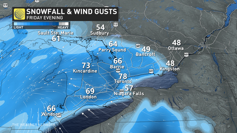
Heavy snow will be accompanied by 60-80 km/h wind gusts, significantly reducing visibility for all roads in southern Ontario late Friday and into the overnight hours. Blizzard conditions are possible across the northern GTA toward Peterborough, though the potential for whiteout conditions will be widespread throughout the region.
Snowfall rates near 3-5 cm per hour will allow wet snow to accumulate in a hurry.
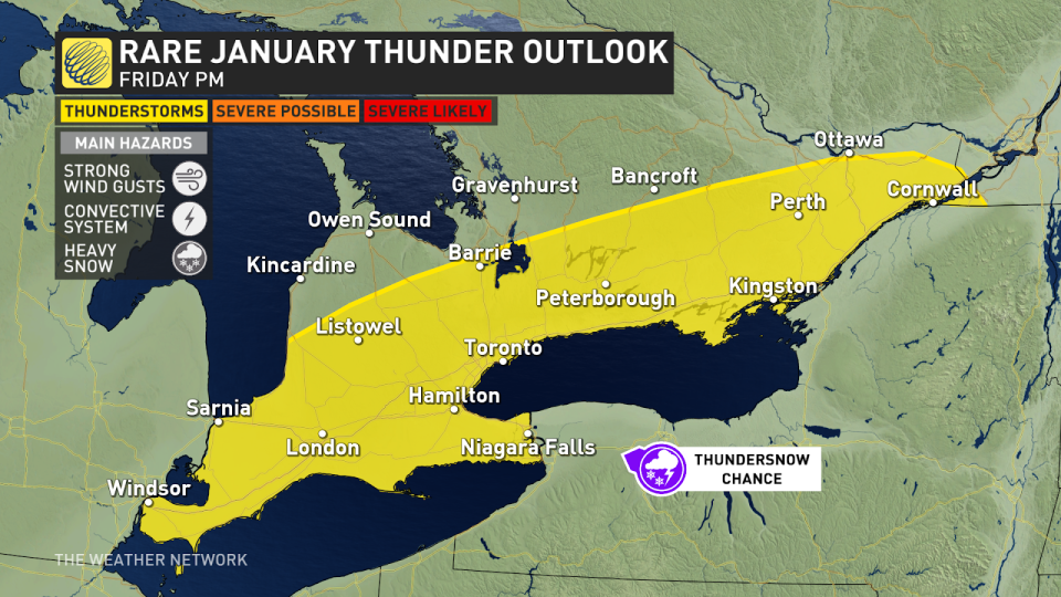
The combination of a fast-strengthening storm and lake enhancement will create a risk for intense snow bands complete with thundersnow across parts of southern Ontario on Friday evening. Locally heavier snowfall totals are possible beneath these bands, making for a tricky forecast.
WATCH: Snowfall ramps up for GTA late Friday afternoon with 3-5 cm per hour
We’ll see a bit of warm air nudge into southwestern Ontario as the heart of the low-pressure system passes to the west overnight Friday into Saturday.
Forecasters expect some changeover to rain across the Lake Erie shores and the Niagara Peninsula during the overnight hours and spread east through early Saturday. This may result in lower snowfall totals where the rain forces some snowmelt.
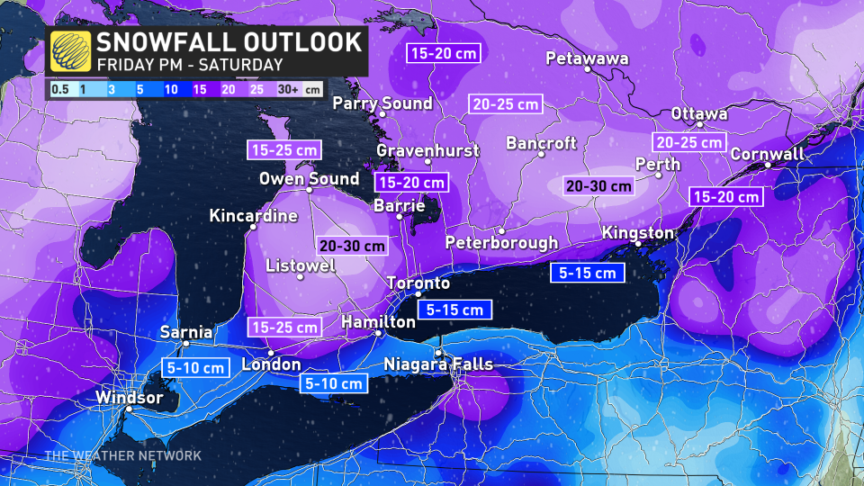
Overall, a widespread swath of 10-20+ cm of snow is possible across southern Ontario through Saturday morning. Locally higher totals are possible along the Dundalk Highlands, with 30+ cm possible around Orangeville. A swath of heavier snow is also possible toward Bancroft east into Ottawa, where forecasters see the potential for 20-25 cm of snow.
Areas that transition over to rain will likely see less than 10 cm of snow from this system.
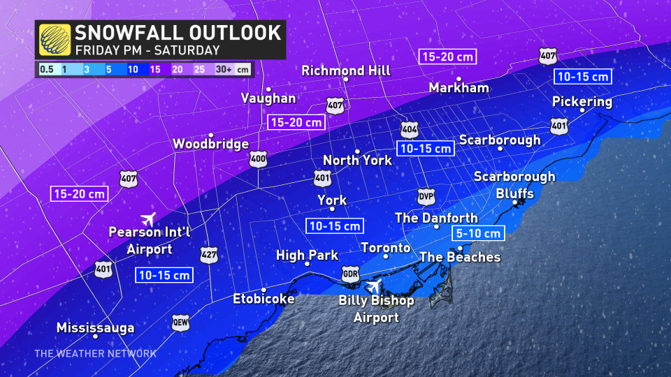
A razor-thin line cuts through the GTHA as only a short distance will separate significant snows from lower totals as the warmer lake forces rain to mix with snow. Snowfall totals across the GTHA are a bit uncertain as a result of this setup, complicated further by whether those bands of heavier snow can overwhelm the lake-influenced warmup.
Beyond: Arctic air switches on the lake-effect snow
A surge of cold air flooding in behind this storm will crank up the lake-effect snow machine across the region. We’ll see a multi-day lake-effect snow setup unfold across the traditional snowbelts.
Northwesterly winds late Saturday will give rise to bands of snow along the Saugeen Shores, Wasaga Beach, Barrie, and the surrounding areas.
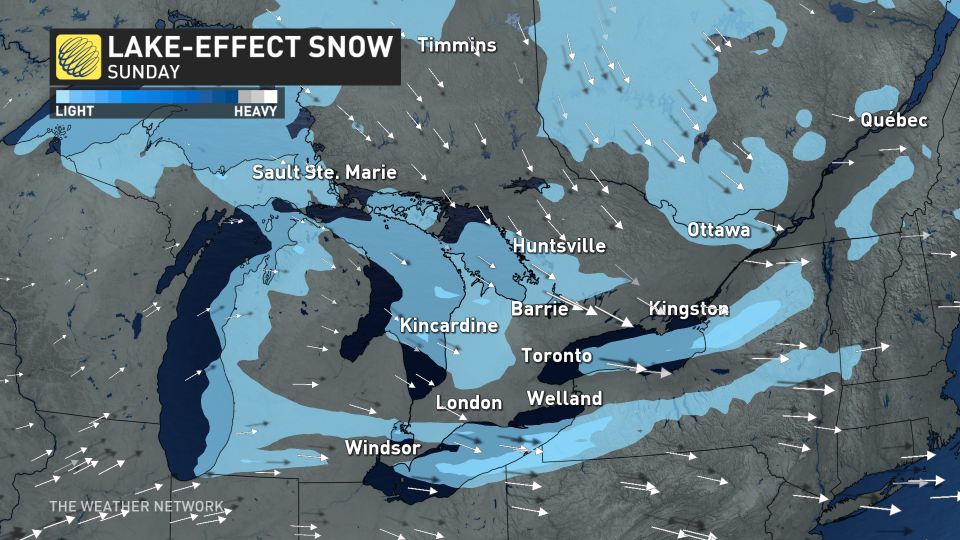
Shifting winds will blow from the west by Sunday into Monday, forcing lake-effect snow to pile up on the Bruce Peninsula and communities east of Georgian Bay, including Parry Sound, Huntsville, Bracebridge, and Gravenhurst.
Stay with The Weather Network for the latest on this high-impact storm across Ontario.

