
Prolonged ice and heavy snow aiming for Atlantic Canada

No rest for the weary across Atlantic Canada as the latest winter storm in as many days threatens widespread disruptions across the region.
Heavy snow, freezing rain, and ice pellets are all in the forecast, beginning Friday in the Maritimes and continuing through Saturday across the Gulf in Newfoundland.
EXCLUSIVE: Wild ride to the winter finish line in Canada, find out your fate

This latest storm is a Texas low that produced destructive thunderstorms in the southern United States and a sloppy mix of snow and ice across Central Canada.
Precipitation will push into the Maritimes during the wee morning hours Friday, gradually increasing in intensity and coverage as Friday morning progresses.
Colder air will allow most of the precipitation to fall as snow across parts of northern and central New Brunswick, as well as the western half of Prince Edward Island.
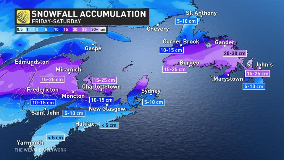
"Rapidly accumulating snow could make travel difficult over some locations," says Environment and Climate Change Canada (ECCC) in the snowfall warning posted for New Brunswick. "Visibility may be suddenly reduced at times in heavy snow."
We can expect 15-25 cm of snow across portions of these provinces—including Fredericton, Moncton, and Summerside—by the end of the storm.
However, farther south, a complex temperature setup will force much of the initial precipitation to fall as ice pellets and freezing rain across parts of the region.
The greatest threat for icing will cover much of Nova Scotia during the day Friday, stretching north to include the Fundy Shores and the eastern half of Prince Edward Island.
We could see up to six hours of ice across these areas before colder air wraps in behind the storm and precipitation changes over to snow through Friday evening.
DON'T MISS: It may be mild, but the snowiest months are just ahead for these parts of Canada
Drivers and pedestrians alike are urged to use caution as untreated surfaces will become slick in areas that experience prolonged icing. Isolated power outages are also possible where ice builds up on trees and power lines.
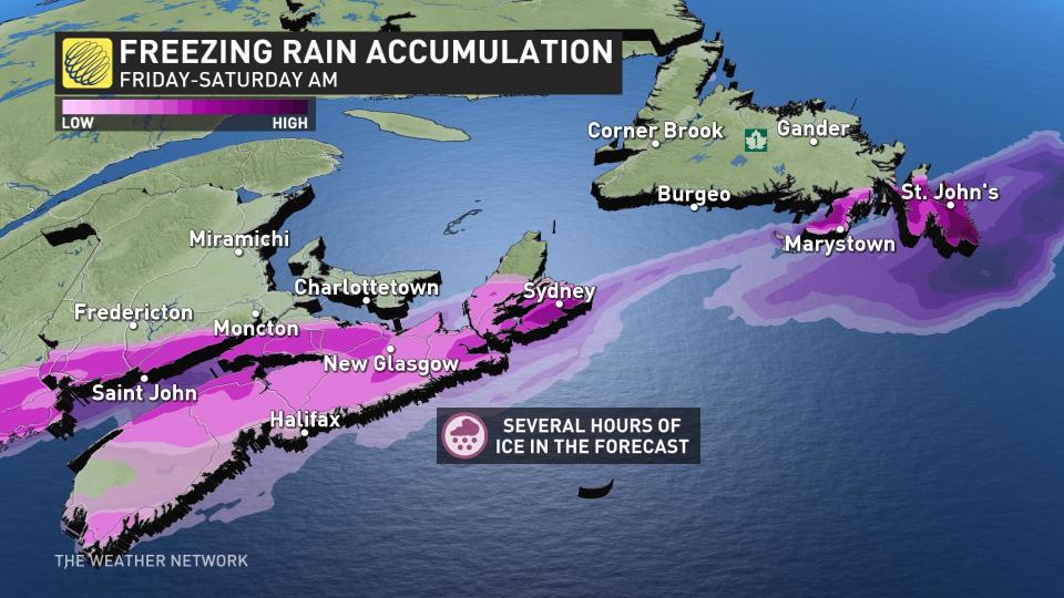
Across the Gulf, a similar dynamic will set up across Newfoundland as the storm arrives Friday evening and lasts into Saturday morning.
The Avalon Peninsula will find itself on the divide between precipitation types.
St. John’s in particular looks like it could experience the wintry spectrum over the course of this system—beginning first as freezing rain, then changing over to ice pellets through the night Friday before switching over to snow as colder air filters in Saturday morning.
Mostly fair and colder temperatures last through this weekend, though temperatures quickly rebound across the Maritimes by Sunday. Low pressure will track north of the region Monday night and into Tuesday, with widespread showers and windy conditions, but with very mild temperatures expected.
Temperatures will once again turn much colder mid to late next week with the potential for some significant wintry and messy weather. Colder than normal temperatures are expected during the final days of February and into early March.
RELATED: What’s up with this winter so far, Canada? We have the answer
Be sure to check back for the latest updates on the weather across Atlantic Canada.

