
Snow totals pile up further in Ontario as lake-effect goes to work
Now that the latest storm has departed Ontario, attention has shifted to a prolonged, lake-effect snow event.
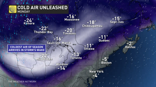
The coldest air of the season will blanket the Great Lakes for the next few days. The lake temperatures are two degrees above normal for this time of year, adding extra fuel to the squalls.
SEE ALSO: Buffalo playoff game postponed, travel ban issued amid blizzard threat
Cold air blowing in behind the storm will move over the warm waters, helping to set off potent snow squall bands. What is impressive about the lake-effect setup is how far it will stretch, potentially reaching into parts of southern Quebec –– an uncommon feature in the province.
Prepare for travel delays in the affected areas, keeping in mind that conditions can shift from clear skies to a near-whiteout in a hurry around snow squalls.
Arctic air switches on the lake-effect snow
The same Arctic air bringing historically cold temperatures to the western half of North America is flooding into the Great Lakes behind our departing storm.
MUST-SEE PHOTOS: Thundersnow, blizzard-like conditions hit Ontario
Frigid winds flowing over the unfrozen water will allow ample bands of lake-effect snow to develop off all five of the lakes. Bands that developed on Saturday will intensify into Sunday, continuing for many areas into Monday.
The west-northwest wind will be strong and persistent through Tuesday.
WATCH: Winter storm brings thundersnow to the Greater Toronto Area
The most intense bands are likely east and northeast of Lake Erie and Lake Ontario through Sunday, which is a potential travel hazard for folks near the St. Lawrence—not to mention bad news for Buffalo-bound football fans.
Whiteouts and blizzard-like conditions are also possible on the northern shores of Lake Erie beneath this particularly boisterous snow squall.
This snow squall band could grow strong enough that it extends far beyond the northwestern shores of Lake Ontario, potentially extending up the St. Lawrence River into southern Quebec.
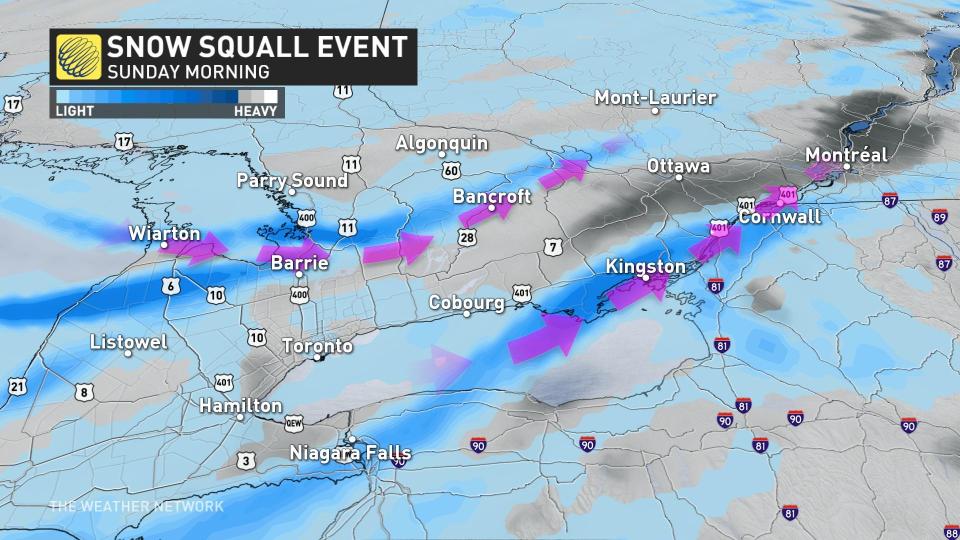
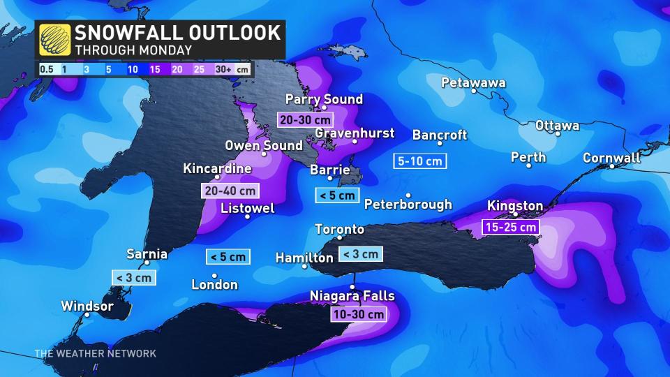
We’re also watching multiple bands of lake-effect snow develop off Lake Huron and Georgian Bay, which will bring steadily accumulating snowfall to the traditional snowbelts through Monday. These bands will affect the Bruce Peninsula and communities like Parry Sound, Huntsville, Bracebridge, and Gravenhurst.
Traffic slowdowns were evident east of Georgian Bay Sunday morning, south of Gravenhurst and Port Severn. Slowdowns were also reported along Highway 402, southeastern parts of the Niagara Peninsula, and east of the city of Kingston.
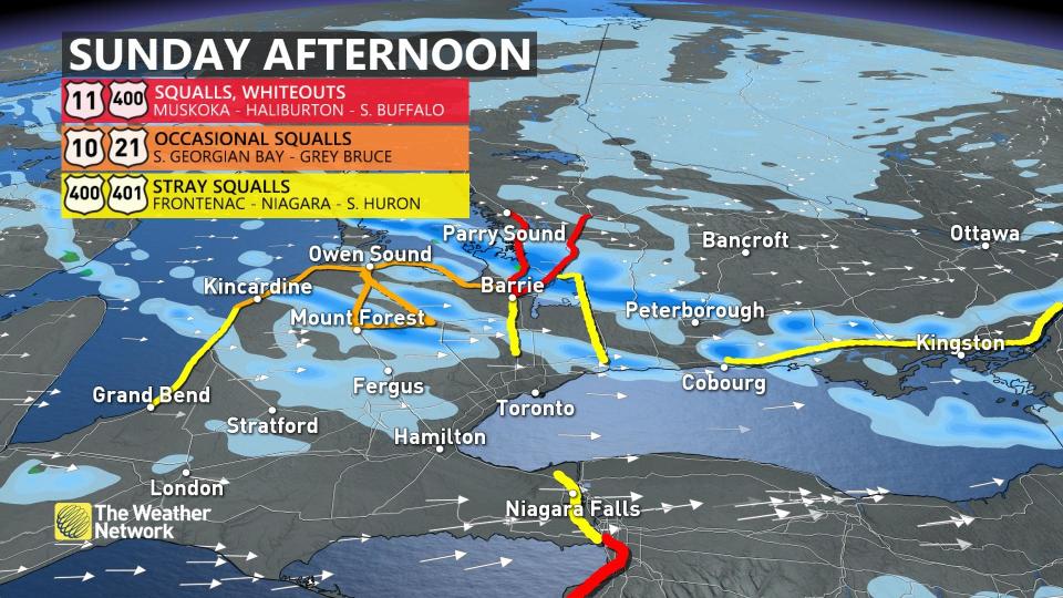
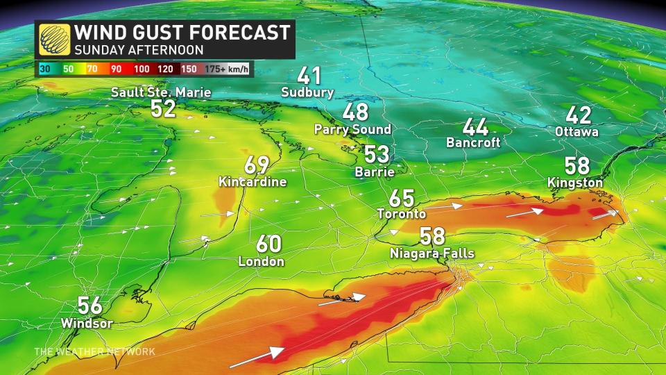
Gusty winds reaching 60-90 km/h will combine with bursts of heavy snow to create whiteout conditions for many of these areas. Wind gusts of 90-100+ km/h are possible along the shores of Lake Huron, Lake Erie, Lake Ontario, and Georgian Bay.
STAY SAFE: Be aware of your heart while shovelling heavy snow
Ontario’s hardest-hit area will likely be Grey-Bruce, thanks to the continuous impact with all wind directions over the next few days. Some of the coldest air will be in far southwestern Ontario, thanks to the Arctic air’s detour south of Lake Michigan and coming in from the U.S. state.
Clear skies can give way to near-whiteout conditions over very short distances around snow squalls, making travel especially dangerous. Plan ahead for delays and prepare for slow-going on snowy, wind-swept roadways.
Snowfall totals from this multi-day event will vary, but the highest amounts could approach 40 cm for areas near Lake Huron.
Folks across portions of the Niagara Peninsula could see more than 20 cm of snow by Sunday with the intense band expected to develop off Lake Erie.
Stay with The Weather Network for the latest on this high-impact storm across Ontario.
Thumbnail courtesy of Getty Images.

