Spring snowfall warnings call for up to 20-30 cm

Ottawa's biggest snowstorm of the year so far may come on April 3 and 4.
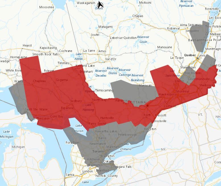
Environment Canada has upgraded more of Tuesday's special weather statements to snowfall warnings for communities along the south, Ontario shore of the Ottawa River.
Ottawa and communities to its south and east such as Brockville and Hawkesbury, plus Gatineau, have a rainy start to Wednesday followed by a change to snow late in the afternoon or early in the evening.
Ten to 20 centimetres of snow could end up falling by the time it peters out Thursday.
After some rain, places west of Ottawa could see 15 to 30 centimetres of snow on a similar timeline.
Environment Canada says be prepared for difficult travel and power outages because the snow may be heavy and wet.
Statements about rain, snow and wind
There are special weather statements around these warnings.
Western Quebec's forecast is for it to take about 24 hours for about 10 to 15 centimetres of wet snow to fall starting Wednesday evening.
Communities south and west of the warning, such as Mallorytown and Tweed, are expected to get 10 to 30 millimetres of rain in the morning and afternoon with a topping of 10 or more centimetres of snow through the night.

Environment Canada's weather advisory map as of about 11:45 a.m. Warnings are in red, special weather statements in grey. (Environment Canada)
Finally, Kingston and communities to its west have a rainfall range of 25 to 50 millimetres. A splattering of wet snow should come after that and it may stick on the ground in some places.
The forecast sticks out in what's been a dry, warm past few months.
Ottawa hasn't had a storm bring at least 20 centimetres of snow since early March 2023. It measured a total of about 20 centimetres of snow in February and March.
Measurements taken at the Ottawa International Airport showed just under 40 millimetres of precipitation last month.
The capital has had four warmer-than-normal months in a row. Daytime temperatures are expected to slip to colder than average Wednesday, Thursday and Friday before rising again on the weekend.


