
Tornado warning ends, severe weather warnings lifted for most of Manitoba
A tornado warning that was briefly in effect for the St. Laurent area has ended, but parts of the Interlake and south-central Manitoba remained under severe weather warnings for much of Tuesday night.
Environment Canada issued the tornado warning at about 6 p.m. CT Tuesday, but it was lifted at about 6:35 p.m.
Severe thunderstorm warnings extended in a column from the Interlake south to the U.S. border. Environment Canada said they were capable of producing quarter-sized hail and strong wind gusts.
"People need to prepare to see lots of lighting, heavy downpours and some short-lived but very gusty winds," CBC Manitoba meteorologist John Sauder said Tuesday night after the tornado warning ended.
A severe thunderstorm warning was issued for parts of western Manitoba on Tuesday morning, while Winnipeg and other areas in the south had a risk of seeing storms later in the day.
It was issued shortly after 11 a.m. CT by Environment Canada to also include the Dauphin, Russell, Roblin, Winnipegosis, Minnedosa, McCreary, and Gladstone areas, but the warnings later ended in those areas.
A low-pressure system moving across the southern part of the province triggered the storms.
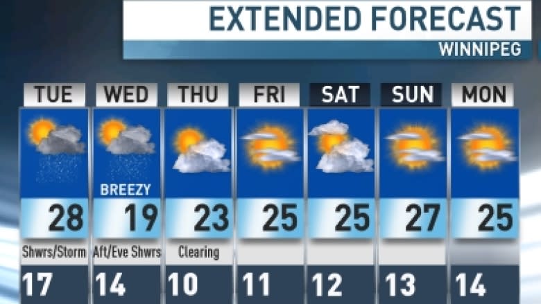
In Winnipeg, humidity levels were projected to be extremely high on Tuesday, making a temperature of 28 C in Winnipeg feel more like 38.
Winnipeg forecast
- High 28 C (humidex 38).
- UV index 6 or high.
- Mix of sun and cloud; hot and humid.
- Chance of an afternoon shower or thunderstorm.
- Wind southeast 20 km/h in morning; north 10 km/h in afternoon.
- Partly cloudy tonight.
- Low 14 C.
Normal temperatures for this time of year are a daytime high of 24 C and an overnight low of 10 C.

