
A storm disturbance forms in the Gulf of Mexico. Here’s the forecast for Mississippi.
A system of low pressure in the Gulf of Mexico could bring rainfall to parts of South Mississippi later this week, the National Weather Service said Monday morning.
The system of showers and thunderstorms is about 100 miles north of Coatzacoalcos, Mexico, and is expected to move slowly north before it merges with a frontal system by the middle of this week, a forecaster with the National Hurricane Center in Miami said.
The system has a low chance of development, the NWS in New Orleans said, but it is expected to cause some severe weather as it moves inland.
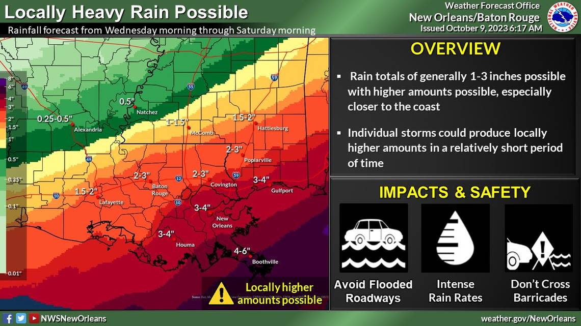
Heavy rainfall, minor coastal flooding and breezy conditions are expected from the system.
“The rain should be beneficial for our area, but flooding could be possible in areas that have high rainfall rates over short periods of time,” the NWS said.
Generally, the forecast shows 1 to 3 inches of rain is possible — with 3 to 4 inches possible in Gulfport — from Wednesday to Friday. The NWS says there is a slight risk of flash flooding from Wednesday afternoon through Thursday for coastal Mississippi.
Minor coastal flooding is possible on east-facing coastlines during high tide on Thursday and Friday.
Breezy conditions are also expected.
Forecast for development in Atlantic
A separate development in the Atlantic Ocean has a higher chance (60 percent) of development in the next two days, the NHC said Monday morning.
The system is expected to strengthen into a tropical depression midweek and will move west-northwest or northwest across the eastern Atlantic, the NHC said.
The system is still far from land, and the forecast is uncertain beyond the next few days.
Keep up with the latest from the tropics on the National Hurricane Center’s website.
Staff writer Hannah Ruhoff contributed to this report.

