
Tammy weakens into post-tropical cyclone: See path, tracker forecast and damage left behind
After spending five days as a hurricane, Tammy has finally weakened, according to Thursday's advisory from the National Hurricane Center.
As of 5 a.m., Tammy has been classified as a post-tropical cyclone, but still producing hurricane-force winds several hundred miles east-southeast of Bermuda. However, the NHC said it is possible "Tammy could reacquire tropical characteristics this weekend or early next week."
The NHC announced Thursday it would no longer issue advisories on Tammy, though cautioned that dangerous swells could bring rip current conditions to Bermuda, the Northern Leeward Islands, the British and U.S. Virgin Islands, and Puerto Rico.
Tammy had been a hurricane for five days. That's the most hurricane days by an Atlantic storm getting named after Oct. 17 since Hurricane Sandy in 2012. It's also tied for fifth-longest since the satellite era began in 1966, according to Philip Klotzbach, Colorado State University meteorologist specializing in Atlantic basin hurricane forecasts.
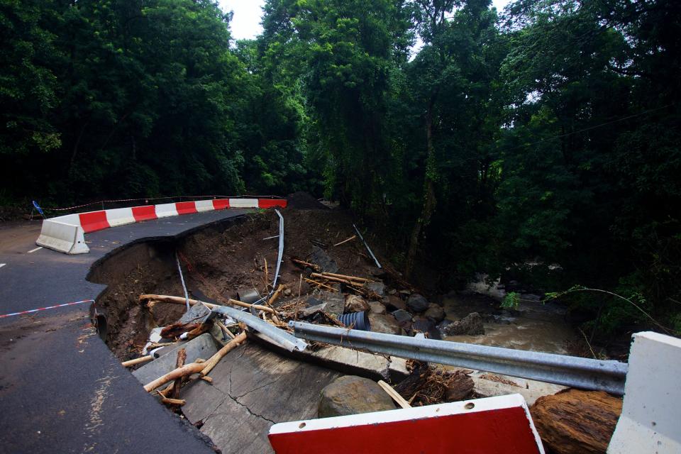
Tammy became a hurricane Friday, Oct. 20 and made landfall in Barbuda on Saturday, Oct. 21. While the damage to Barbuda was minor, nearby Caribbean island Guadalupe suffered major infrastructural damages.
Here is what else to know about Post-Tropical Cyclone Tammy as it weakens in the Atlantic:
Rapid intensification: Scientist says rapidly intensifying hurricanes 'particularly concerning' for coastal communities
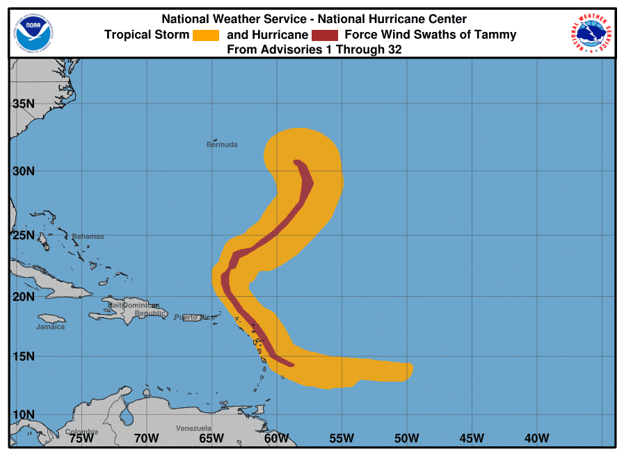
Post-Tropical Cyclone Tammy projected path, tracker
Special note on the NHC cone: The forecast track shows the most likely path of the center of the storm. It does not illustrate the full width of the storm or its impacts, and the center of the storm is likely to travel outside the cone up to 33% of the time.

Location: 395 miles southeast of Bermuda
Maximum sustained winds: 85 mph
Movement: north at 12 mph
Spaghetti models for Post-Tropical Cyclone Tammy
Special note about spaghetti models: Illustrations include an array of forecast tools and models, and not all are created equal. The hurricane center uses only the top four or five highest performing models to help make its forecasts.
What to know about spaghetti models: Where is Tropical Storm Tammy heading? This controversial graphic has answers.
Tammy left damage in Guadeloupe

Tammy made landfall over the island of Barbuda as a Category 1 hurricane Saturday night, according to the National Hurricane Center.
The island did not sustain major infrastructural damages, but did see heavy rainfall and high winds, according to the Associated Press. The storm also knocked down power lines causing an island-wide blackout.
In Guadeloupe, no injures were reported however there was significant damage to buildings and infrastructure, Radio France Internationale reported.
Hurricane Otis strikes Acapulco as one of the strongest storms ever to hit Mexico
Acapulco, Mexico, endured one of the strongest storms on record to hit the country from the Pacific Ocean when Hurricane Otis made landfall early Wednesday as a Category 5 hurricane with 165-mph winds.
The full extent of damages, along with the number of potential injuries and deaths, remains unclear due to communications disruptions and the main highway into Acapulco being impassable.
Videos on social media and television footage Wednesday showed hotels, restaurants, streets and bridges to be mostly underwater. Large buildings and other structures had missing walls and roofs.
Otis blew up from a tropical storm with 70-mph winds to a Category 5 hurricane with 165-mph winds in 13 hours, advisories from the NHC show.
Hurricane Otis: Hurricane Otis strikes Acapulco as one of the strongest storms ever to hit Mexico
When does hurricane season end?
With Tammy named, that leaves two names remaining on the 2023 list of storms: Vince and Whitney. Hurricane season doesn't end until Nov. 30, although storms can and do form any time.
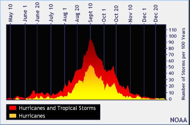
This season has been above the historical average when it comes to named storms. During an average hurricane season, 14 named storms form in the Atlantic basin, which covers the Atlantic Ocean, Caribbean Sea and Gulf of Mexico.
The peak of the season is Sept. 10, with the most activity happening between mid-August and mid-October, according to the hurricane center.
After hurricane season NOAA winter 2023-2024 forecast: Here's where it's expected to be unusually warm this year
Storms being tracked by the National Hurricane Center

Noaa
Embedded content: https://www.nhc.noaa.gov/xgtwo/two_atl_0d0.png?052051
This article originally appeared on Treasure Coast Newspapers: Post-tropical cyclone Tammy: Path, tracker forecast and damage

