
Temperatures soar in B.C. as spring-like warmth brings May feel

This week will offer a tour of the seasons in British Columbia as a mid-winter pattern abruptly lurches to a setup resembling May.
Whistler-Blackcomb has nearly doubled its total snowfall accumulation over the past four to five weeks, now surging close to 900 cm of snowfall accumulation for the season –– just a couple metres below normal. The season is now on pact for similar snowfall to the 2018-19 and 2019-2020 ski seasons.
On Feb. 1, Mount Washington on Vancouver Island had just a 44-cm snow base, which has now increased to 220 cm in under six weeks.
SEE ALSO: Woman survives being buried by avalanche for almost 20 minutes
The ski hills will lose some snowpack with the impending pattern change, but there are signs to finish the month with more accumulating snowfall on higher terrain.

But first, the warmth.
We tend to go from feast to famine lately. Some patterns overstay their welcome, while others bring rapid weather changes in short order. The upper atmosphere over Western Canada is undergoing a big shift over the next 48 hours, allowing B.C. to swing to May conditions in just a couple of days.
A significant ridge of high pressure will build across the province on Thursday, spiralling temperatures across northern B.C. up to 15 degrees above normal.
On Friday, the massive warm-up envelops the southern Interior and coastal regions, pushing temperatures 8-12 degrees above normal for this time of year.
Air sinks beneath upper-level ridges, warming up as it descends toward the surface. This setup will force temperatures to steadily rise heading toward next weekend.
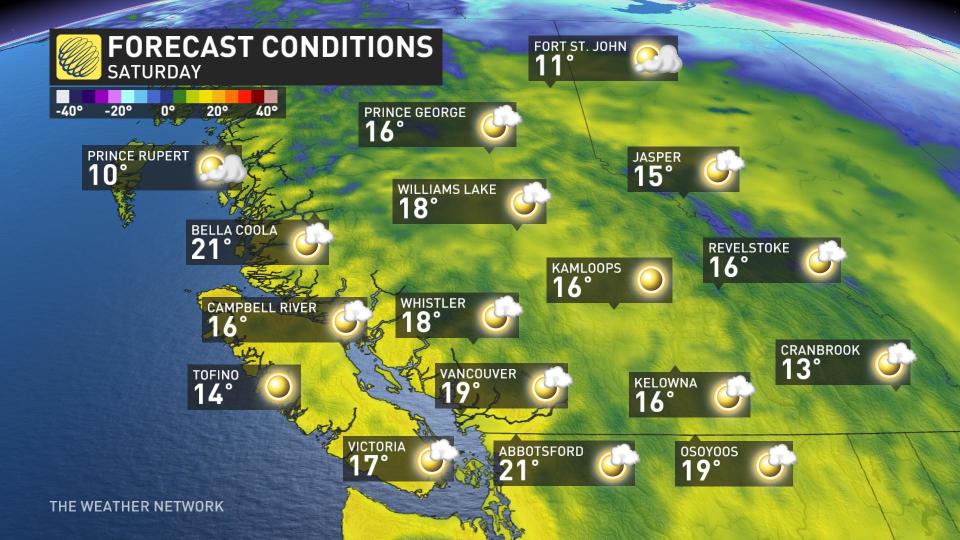
Saturday is even warmer. Our first day where inland temperatures will spill past 20 degrees in 2024.
Locations like Chilliwack, Abbotsford, Port Alberni, and Maple Ridge all have the opportunity to surpass the 20°C mark.
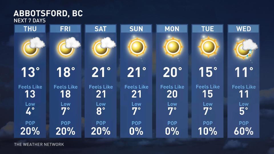
Abbotsford will likely reach 20°C on three consecutive days, one of the earliest instances of that occurring on record.
Temperatures later this weekend look to peak through the Interior, well into the upper teens for Kamloops, Kelowna and the Okanagan.
WATCH: Surviving a tree well: The hidden danger on ski hills
The strong warmth anomaly extends through the Caribou and Prince George region with temperatures teetering close to 20°C this weekend.
Watch for increased snowmelt with rapidly melting snow below 2000 metres in elevation and elevated streamflows through early next week.
Temperatures are forecast to return to seasonal values later this month with a return to unsettled conditions and more alpine snow.
With files from Tyler Hamilton, a meteorologist at The Weather Network.
Thumbnail courtesy of Unsplash.
Stay tuned to The Weather Network for the latest forecast updates for B.C.

