
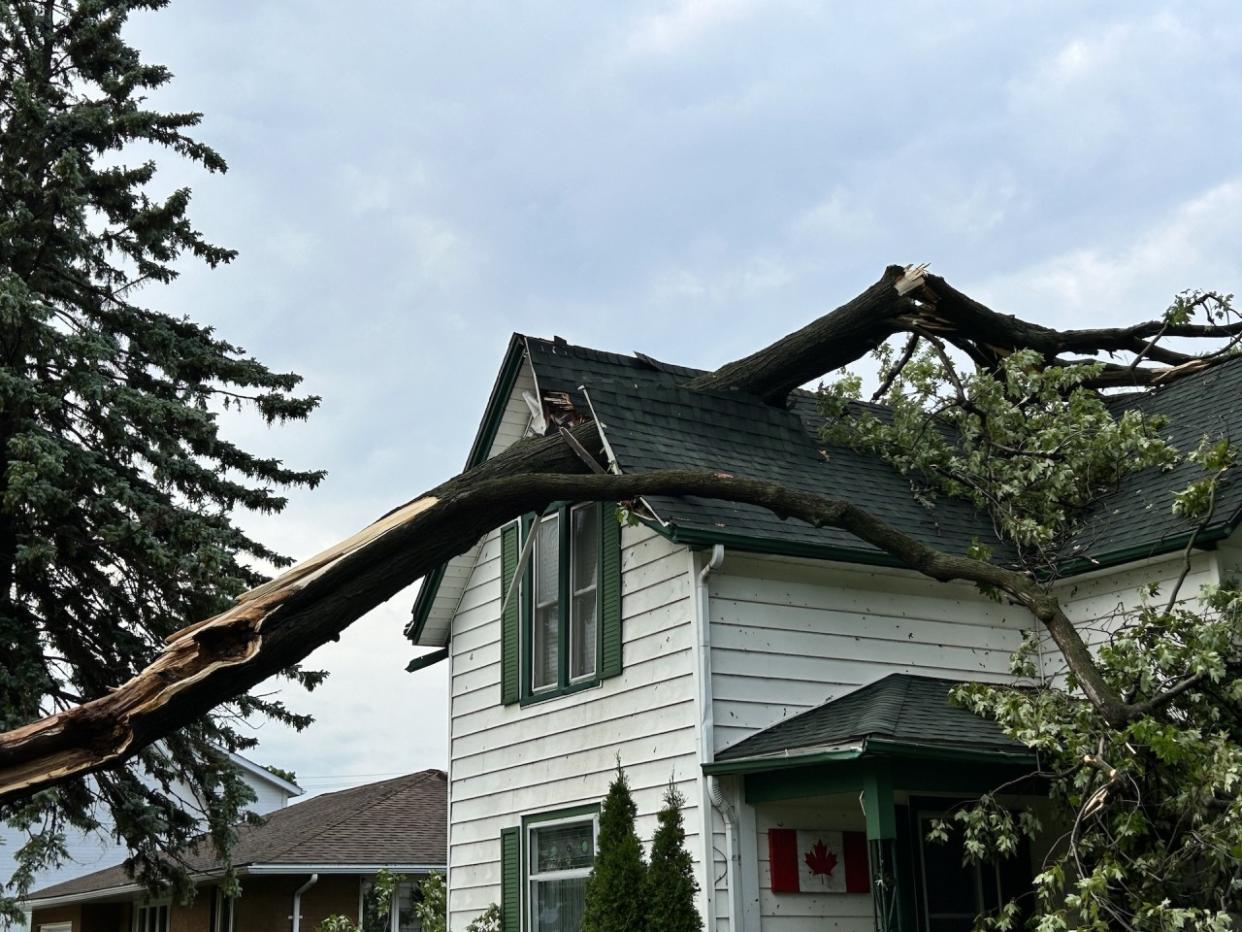
Severe storms eye southern Ontario tonight, risk of strong winds, tornadoes
A cluster of thunderstorms will intensify as it tracks toward southern Ontario Wednesday evening. All severe weather hazards are on the table.
The threat includes a squall line with damaging winds, large hail, and one or two tornadoes, all of which are possible in southwestern regions of the province. People will need to be weather-aware and heed all warnings.
RELATED: PHOTOS: Damage reported after tornado-warned storms hit southern Ontario
The storm risk will be timed with a bout of hot weather, with many regions looking at a few consecutive days above 30°C. In some places, these could be the hottest days of summer so far.
Wednesday
Area: Ontario
Timing: Late afternoon, evening and overnight
Weather: An incoming squall line will move into southwestern Ontario Wednesday evening, bringing the risk of damaging wind gusts, large hail, and the chance of a few QLCS tornadoes. The timing is a bit later compared to the more recent storms. There is also the risk of some storms developing south of Georgian Bay this afternoon, though will be less severe in nature than the storms forecast in the southwest.

One of the biggest differences compared to the storms that swept through the region last week is the size of hail.
PHOTOS: 'Windshield-busting hail' blasts Alberta as tornado-warned storms hit
Although there is the chance for hail up to toonie-sized, that is significantly smaller than tennis- and baseball-size hail from last week's squall line.
As the storms approach the Golden Horseshoe later tonight, they will begin to weaken, but some could still remain severe, with strong wind gusts and heavy rain.
Confidence: There is good confidence that a squall line will impact southwestern Ontario tonight, but where the confidence decreases is the exact timing of the line. Confidence is also lower if storms do develop ahead of the squall line in parts of southern Ontario.
WATCH: Multiple squall lines move into Ontario, what to expect
Building heat could bring some of the warmest temperatures of the summer
The strong heat dome situated over the central U.S. tilts across the Upper Midwest and Great Lakes basin by Wednesday and Thursday.
Wednesday will be the first scorching day of the week with widespread 30-degree temperatures forecast all across southern Ontario. A heat warning is in effect.
RELATED: Four simultaneous heat domes break major records across the globe
Windsor is looking at four consecutive days above 30°C. It’s likely that the maximum temperatures of this heat event will push close to 35°C for a couple of weather stations in extreme southern Ontario.
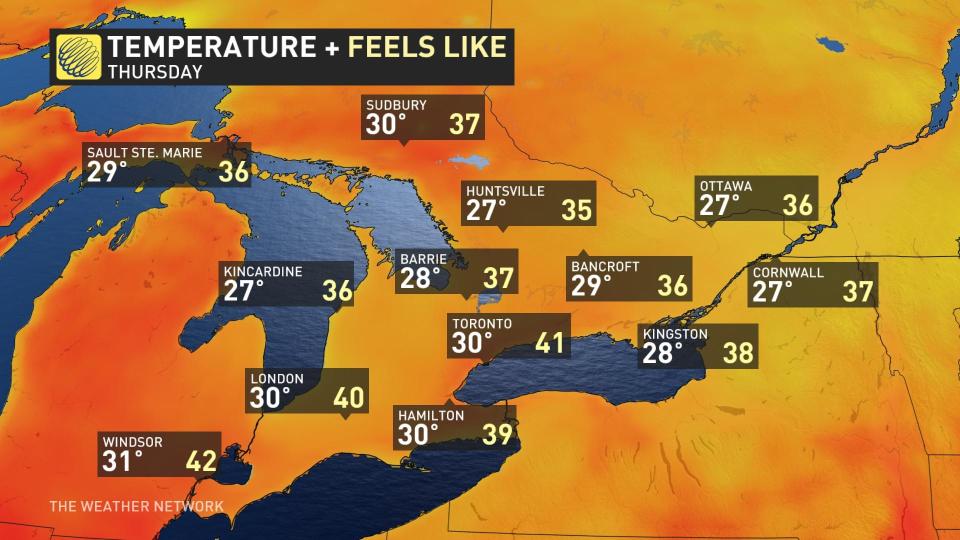
What’s more concerning are the overnight temperatures that are forecast to stay elevated in the low 20s, even through the pre-dawn hours. Those without access to air conditioning will get little reprieve from the heat.
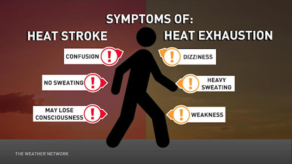
Keep an eye out for symptoms of heat exhaustion and heat stroke in those most susceptible.
Cooler temperatures are expected by Saturday.
Once the storms started pushing into southwestern Ontario Wednesday, it didn't take long for the visuals to appear on social media. Here is a selection of what is currently making the rounds.
HYDRO POLES DOWN - Essex / Gesto4:30pm- 1100 block of Gesto Side Rd- x4 hydro poles down- @EssexON_Fire Station 2 on scene - Road is closed #EssexCounty #onstorm pic.twitter.com/MR43jL05Cw
HYDRO POLES DOWN - Essex / Gesto
4:30pm
- 1100 block of Gesto Side Rd
- x4 hydro poles down
- On Location on Twitter: "HYDRO POLES DOWN - Essex / Gesto4:30pm- 1100 block of Gesto Side Rd- x4 hydro poles down- @EssexON_Fire Station 2 on scene - Road is closed #EssexCounty #onstorm pic.twitter.com/MR43jL05Cw / Twitter" Station 2 on scene
- Road is closed On Location on Twitter: "HYDRO POLES DOWN - Essex / Gesto4:30pm- 1100 block of Gesto Side Rd- x4 hydro poles down- @EssexON_Fire Station 2 on scene - Road is closed #EssexCounty #onstorm pic.twitter.com/MR43jL05Cw / Twitter" On Location on Twitter: "HYDRO POLES DOWN - Essex / Gesto4:30pm- 1100 block of Gesto Side Rd- x4 hydro poles down- @EssexON_Fire Station 2 on scene - Road is closed #EssexCounty #onstorm pic.twitter.com/MR43jL05Cw / Twitter" On Location on Twitter: "HYDRO POLES DOWN - Essex / Gesto4:30pm- 1100 block of Gesto Side Rd- x4 hydro poles down- @EssexON_Fire Station 2 on scene - Road is closed #EssexCounty #onstorm pic.twitter.com/MR43jL05Cw / Twitter"— On Location (@_OnLocation_) On Location on Twitter: "HYDRO POLES DOWN - Essex / Gesto4:30pm- 1100 block of Gesto Side Rd- x4 hydro poles down- @EssexON_Fire Station 2 on scene - Road is closed #EssexCounty #onstorm pic.twitter.com/MR43jL05Cw / Twitter"
Here comes the line near Dresden! @weathernetwork #ONStorm pic.twitter.com/5FFNU7uhTY
Here comes the line near Dresden! Mark Robinson on Twitter: "Here comes the line near Dresden! @weathernetwork #ONStorm pic.twitter.com/5FFNU7uhTY / Twitter" Mark Robinson on Twitter: "Here comes the line near Dresden! @weathernetwork #ONStorm pic.twitter.com/5FFNU7uhTY / Twitter" Mark Robinson on Twitter: "Here comes the line near Dresden! @weathernetwork #ONStorm pic.twitter.com/5FFNU7uhTY / Twitter"
— Mark Robinson (@StormhunterTWN) Mark Robinson on Twitter: "Here comes the line near Dresden! @weathernetwork #ONStorm pic.twitter.com/5FFNU7uhTY / Twitter"
ONstorm #SevereWeather #thunderstorm #Windsor #yqg #onwx Power was out, and the rains were very heavy for about 7 minutes.Here are some photos for you all. ♥ ⛈️ pic.twitter.com/kHjNrPceuB
Rosyla Streaming Network on Twitter: "#ONstorm #SevereWeather #thunderstorm #Windsor #yqg #onwx Power was out, and the rains were very heavy for about 7 minutes.Here are some photos for you all. ♥ ⛈️ pic.twitter.com/kHjNrPceuB / Twitter" Rosyla Streaming Network on Twitter: "#ONstorm #SevereWeather #thunderstorm #Windsor #yqg #onwx Power was out, and the rains were very heavy for about 7 minutes.Here are some photos for you all. ♥ ⛈️ pic.twitter.com/kHjNrPceuB / Twitter" Rosyla Streaming Network on Twitter: "#ONstorm #SevereWeather #thunderstorm #Windsor #yqg #onwx Power was out, and the rains were very heavy for about 7 minutes.Here are some photos for you all. ♥ ⛈️ pic.twitter.com/kHjNrPceuB / Twitter" Rosyla Streaming Network on Twitter: "#ONstorm #SevereWeather #thunderstorm #Windsor #yqg #onwx Power was out, and the rains were very heavy for about 7 minutes.Here are some photos for you all. ♥ ⛈️ pic.twitter.com/kHjNrPceuB / Twitter" Rosyla Streaming Network on Twitter: "#ONstorm #SevereWeather #thunderstorm #Windsor #yqg #onwx Power was out, and the rains were very heavy for about 7 minutes.Here are some photos for you all. ♥ ⛈️ pic.twitter.com/kHjNrPceuB / Twitter" Rosyla Streaming Network on Twitter: "#ONstorm #SevereWeather #thunderstorm #Windsor #yqg #onwx Power was out, and the rains were very heavy for about 7 minutes.Here are some photos for you all. ♥ ⛈️ pic.twitter.com/kHjNrPceuB / Twitter"
Power was out, and the rains were very heavy for about 7 minutes.
Here are some photos for you all. ♥ ⛈️ Rosyla Streaming Network on Twitter: "#ONstorm #SevereWeather #thunderstorm #Windsor #yqg #onwx Power was out, and the rains were very heavy for about 7 minutes.Here are some photos for you all. ♥ ⛈️ pic.twitter.com/kHjNrPceuB / Twitter"— Rosyla Streaming Network (@Rosyla_SN) Rosyla Streaming Network on Twitter: "#ONstorm #SevereWeather #thunderstorm #Windsor #yqg #onwx Power was out, and the rains were very heavy for about 7 minutes.Here are some photos for you all. ♥ ⛈️ pic.twitter.com/kHjNrPceuB / Twitter"
A common scene in Kingsville right now. Some larger trees down. #ONStorm pic.twitter.com/r4AOgVxM04
A common scene in Kingsville right now. Some larger trees down. Steve I'Anson on Twitter: "A common scene in Kingsville right now. Some larger trees down. #ONStorm pic.twitter.com/r4AOgVxM04 / Twitter" Steve I'Anson on Twitter: "A common scene in Kingsville right now. Some larger trees down. #ONStorm pic.twitter.com/r4AOgVxM04 / Twitter"
— Steve I'Anson (@sianson79) Steve I'Anson on Twitter: "A common scene in Kingsville right now. Some larger trees down. #ONStorm pic.twitter.com/r4AOgVxM04 / Twitter"
Visibly rotating wall cloud coming into Casselman @ECCCWeatherON #onstorm 3:48 pic.twitter.com/LZSt0dXiVH
Visibly rotating wall cloud coming into Casselman Connor Mockett on Twitter: "Visibly rotating wall cloud coming into Casselman @ECCCWeatherON #onstorm 3:48 pic.twitter.com/LZSt0dXiVH / Twitter" Connor Mockett on Twitter: "Visibly rotating wall cloud coming into Casselman @ECCCWeatherON #onstorm 3:48 pic.twitter.com/LZSt0dXiVH / Twitter" 3:48 Connor Mockett on Twitter: "Visibly rotating wall cloud coming into Casselman @ECCCWeatherON #onstorm 3:48 pic.twitter.com/LZSt0dXiVH / Twitter"
— Connor Mockett (@ConnorMockettWX) Connor Mockett on Twitter: "Visibly rotating wall cloud coming into Casselman @ECCCWeatherON #onstorm 3:48 pic.twitter.com/LZSt0dXiVH / Twitter"
Thunderstorm is arriving in #Amherstburg. #ONStorm @weathernetwork @StormhunterTWN pic.twitter.com/2TpjUQuDUG
Thunderstorm is arriving in Ron Giofu on Twitter: "Thunderstorm is arriving in #Amherstburg. #ONStorm @weathernetwork @StormhunterTWN pic.twitter.com/2TpjUQuDUG / Twitter". Ron Giofu on Twitter: "Thunderstorm is arriving in #Amherstburg. #ONStorm @weathernetwork @StormhunterTWN pic.twitter.com/2TpjUQuDUG / Twitter" Ron Giofu on Twitter: "Thunderstorm is arriving in #Amherstburg. #ONStorm @weathernetwork @StormhunterTWN pic.twitter.com/2TpjUQuDUG / Twitter" Ron Giofu on Twitter: "Thunderstorm is arriving in #Amherstburg. #ONStorm @weathernetwork @StormhunterTWN pic.twitter.com/2TpjUQuDUG / Twitter" Ron Giofu on Twitter: "Thunderstorm is arriving in #Amherstburg. #ONStorm @weathernetwork @StormhunterTWN pic.twitter.com/2TpjUQuDUG / Twitter"
— Ron Giofu (@RonGiofu) Ron Giofu on Twitter: "Thunderstorm is arriving in #Amherstburg. #ONStorm @weathernetwork @StormhunterTWN pic.twitter.com/2TpjUQuDUG / Twitter"
Wow! Geeenage! Hail in there. @weathernetwork pic.twitter.com/m9FJ2JYQ4K
Wow! Geeenage! Hail in there. Mark Robinson on Twitter: "Wow! Geeenage! Hail in there. @weathernetwork pic.twitter.com/m9FJ2JYQ4K / Twitter" Mark Robinson on Twitter: "Wow! Geeenage! Hail in there. @weathernetwork pic.twitter.com/m9FJ2JYQ4K / Twitter"
— Mark Robinson (@StormhunterTWN) Mark Robinson on Twitter: "Wow! Geeenage! Hail in there. @weathernetwork pic.twitter.com/m9FJ2JYQ4K / Twitter"
Stay with The Weather Network for the latest on conditions across Ontario.
