
South Florida faces 'high risk' of flash flooding after 20-plus inches of rainfall
A state of emergency remains in effect for five counties across South Florida after severe flooding swamped the region on Wednesday, and the threat is far from over as forecasters have placed a swath of South Florida under a rare "high risk" of flash flooding on Thursday.
High risks are only issued on about 4% of days, but this risk category accounts for 39% of flood-related fatalities and 83% of flood-related damages in the continental U.S., according to research by meteorologists at NOAA's Weather Prediction Center.
WHY RARE ‘HIGH RISK' FLOOD DAYS NEED TO BE TAKEN SERIOUSLY
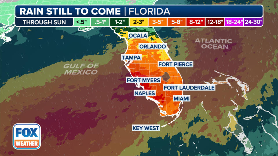
A general 3-8 inches of rain has already fallen across Southwest and South Florida, while areas along Interstate 75 in the Everglades and Interstate 95 in the Miami metro area have picked up an incredible 15-25 inches of rain already.
Gov. Ron DeSantis declared a state of emergency for Broward, Collier, Lee, Miami-Dade and Sarasota counties due to severe flooding.
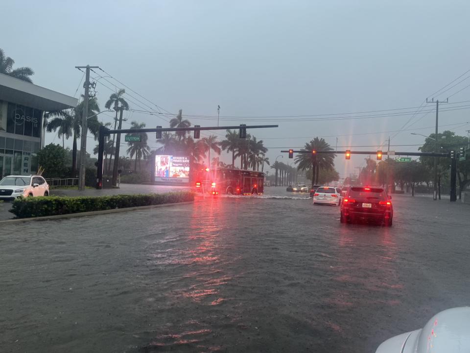
Another dangerous day lies ahead Thursday for the Miami metro with more heavy rain anticipated. The intense amounts of rain that fell across Miami-Dade County led to a Flash Flood Emergency declared just after 3:30 p.m. Wednesday.
The warning included Fort Lauderdale-Hollywood International Airport, where there were reports of standing water on the runway and dozens of delays and cancellations. More than a half-million residents were included in the alert, which included the communities of Pembroke Pines, Hollywood and Miramar.
Fort Myers broke a 40-year-old record with nearly 4 inches of rain falling in 24 hours, while Sarasota saw a record 3.93 inches in one hour on Tuesday.
Mayors in both Fort Lauderdale and Miami-Dade County declared local states of emergency to help with cleanup and recovery.
Broward County Public Schools announced they'll be closed on Thursday due to ongoing flooding.
Multiple inches of additional rain are likely in the coming days, and some spots may still pick up an additional 10-plus inches.
According to Martin County Fire Rescue, a tornado on Wednesday morning caused damage in parts of Hobe Sound, Florida, about 25 miles north of West Palm Beach. Some homes were reported to have sustained damage, and power outages were reported in some neighborhoods.
Just south of Hobe Sound, portions of Jupiter Island were inaccessible after trees were knocked down by the tornado. Martin County Fire Rescue said it was working to clear the affected roads.
A National Weather Service survey crew confirmed that the damage was consistent with an EF-1 tornado that had peak winds of 85-95 mph.
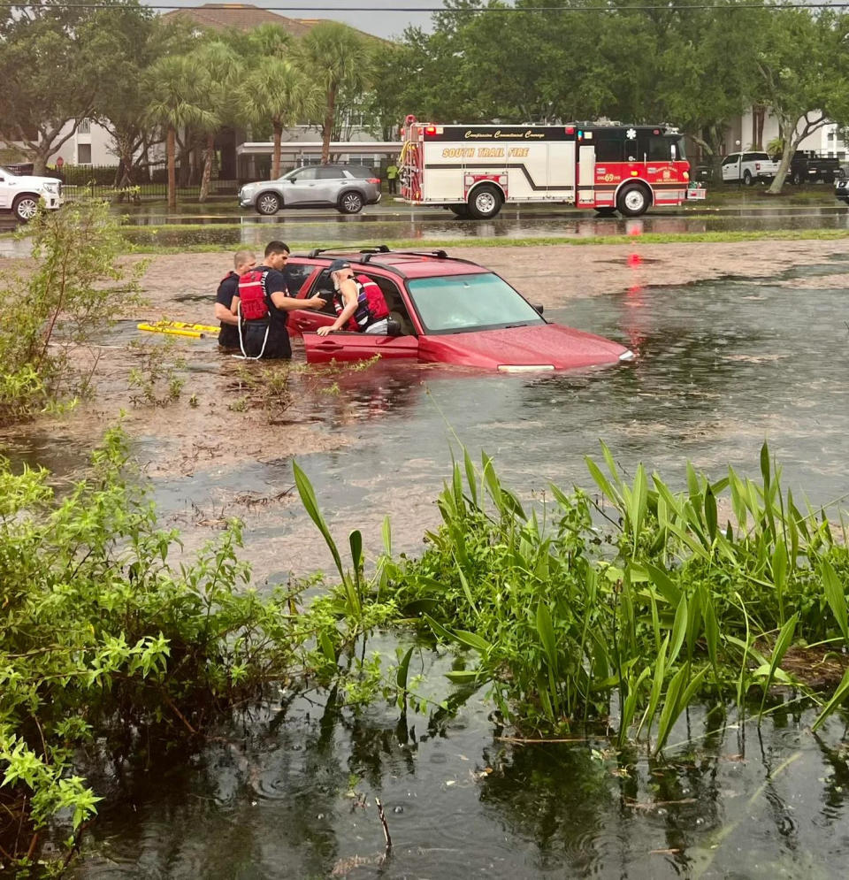
Firefighters in the Fort Myers region said they performed a water rescue of a man trapped inside an SUV on Wednesday morning.
First responders said floodwater was over the driver's lap, and the car was sinking into the mud when they arrived.
They quickly got the distressed man out of the vehicle and found no other victims needing rescue.
"If you can stay home, please do. If you have to be on the roads, always wear your seat belt and drive the speed appropriate for the weather and road conditions," the South Trail Fire & Rescue stated.
Radar estimates showed 7-12 inches of rain fell Tuesday evening in parts of Southwest Florida.
Sarasota, Florida, recorded 6.47 inches of rain Tuesday, marking the city's 11th-wettest day overall since records began in 1911. The rainfall also secured its place as the fourth-wettest June day and set a new daily rainfall record for June 11. Sarasota even broke its all-time one-hour rainfall record when 3.93 inches fell in a single hour.
The heavy rainfall led to flooding in downtown Sarasota, with several vehicles that were partially submerged.
Remarkably, the amount of rain that fell in Sarasota on Tuesday exceeded the total rainfall it received in February (3.26 inches), March (1.04 inches), April (1.02 inches) and May (0.02 inches) combined.
In North Florida, Gainesville also broke its all-time one-hour rainfall record Tuesday with 3.92 inches falling in a single hour, highlighting the intensity of the weather event across the state.
A deadly traffic crash that occurred in Collier County on Tuesday is believed to have been weather-related. Troopers told FOX4 in Southwest Florida that two people died after a driver lost control of a vehicle on a wet roadway.
Original article source: South Florida faces 'high risk' of flash flooding after 20-plus inches of rainfall

