
Texas braces for up to 10 inches of rain as Tropical Storm Alberto bears down
CORPUS CHRISTI, Texas − An enormous storm system sweeping across the Gulf of Mexico strengthened Wednesday into Tropical Storm Alberto, the first named storm of the 2024 Atlantic hurricane season, as parts of Texas braced for almost a foot of rain. Areas of Mexico could be deluged with 20 inches.
The National Hurricane Center issued a tropical storm warning for the Texas coast from San Luis Pass south to the mouth of the Rio Grande River. Gov. Greg Abbott issued a disaster declaration for 51 counties and activated three platoons of the Texas National Guard, including more than 40 personnel, 20 vehicles and Chinook helicopters.
"Several hazards will be felt over South Texas through Thursday due to the large extent and slow movement of this system," the National Weather Service in Corpus Christi warned.
Culprits included flash flooding, coastal and river flooding, rip currents and wind gusts over 50 mph, the weather service said. Several roads in Corpus Christi were already closed Wednesday because of high water as the storm approached. And the state Transportation Department's online highway condition map showed several alerts related to water on roadways across the region.
Footage on social media showed flooding from coastal communities south of Galveston, Texas, to the Mexican border town of Reynosa.
The weather service issued a tornado watch Wednesday evening lasting until Thursday morning for the south Texas coastal areas hit by the storm and as far inland as Laredo.
Alberto is the first named storm of what's expected to be an especially active season for hurricanes in the Atlantic Ocean, which also include storms that form in the Gulf of Mexico and Caribbean Sea.
Alberto also marks an unusually late start to the season: Not since 2014 has there been such a late start. That year, the first storm – Arthur – formed on June 30.
Mexico could see mudslides, 20 inches of rain
Alberto is expected to produce rainfall totals of 5 to 10 inches across northeast Mexico into South Texas, forecasters said. Up to 20 inches are possible across the higher terrain of the Mexican states of Coahuila, Nuevo Leon and Tamaulipas. The storm will likely produce considerable flash and urban flooding along with new and renewed river flooding, forecasters said. Mudslides are also possible in areas of higher terrain across northeast Mexico.
Coahuila Gov. Manolo Jiménez Salinas said he was coordinating with the Mexican army and national guard.
Where is Alberto now?
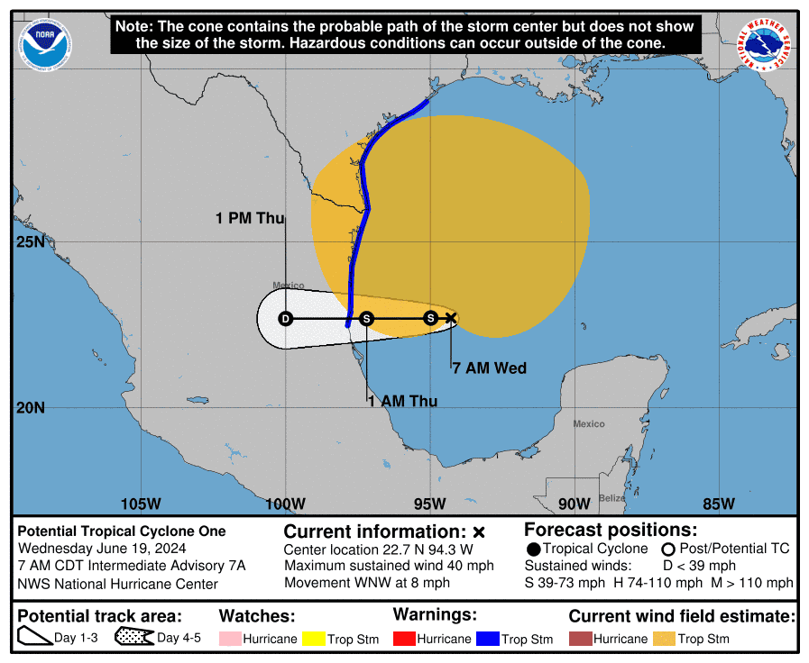
As of 5 p.m. EDT, the center of Tropical Storm Alberto was 305 miles south-southeast of Brownsville, Texas. The storm was driving maximum sustained winds of 40 mph and was moving to the west at 9 mph, the hurricane center said. Some slight strengthening is forecast before landfall along Mexico's northeastern coast early Thursday.
Alberto is a large storm, and tropical storm-force winds extend outward up to 415 miles. However, rapid weakening is expected as the storm moves inland, and Alberto is likely to dissipate over Mexico by Thursday night.
Alberto to bring life-threatening surf to Texas coast
Tornadoes are possible into Thursday across parts of Deep South Texas and Southeast Texas, the hurricane center said. Parts of Texas could see a storm surge of up to 4 feet. And swells generated by Alberto along the coast of Texas and northeastern Mexico through Friday are likely to cause "life-threatening surf and rip current conditions," the hurricane center said.
"Near the coast, the surge will be accompanied by large and destructive waves," the hurricane center warned.
Record predictions: The 2024 NOAA hurricane season forecast is unlike any other
An active season is predicted
Federal forecasters last month predicted an "extraordinary" season with as many as 25 named storms possible.
This is the most storms the National Oceanic and Atmospheric Administration has ever predicted in a preseason outlook. "All the ingredients are in place for an active season," said National Weather Service director Ken Graham at a news conference in Washington, D.C.
NOAA director Rick Spinrad said the Atlantic hurricane season is shaping up to be "extraordinary": An 85% chance for an above-average year. "The forecast … is the highest NOAA has ever issued for the May outlook," he said at the news conference.
Drought relief could be headed to Southeast
A cluster of showers and thunderstorms east of the Bahamas is taking aim at the eastern coast of Florida, southeastern Alabama and South Carolina, and could bring much-needed moisture into the region, AccuWeather reports. From late Thursday to Saturday, 1-2 inches of rain could fall along the Southeast coast. If the system strengthens to tropical storm status, it would be named Beryl.
"Regardless of development, this feature can bring high seas, gusty winds and areas of heavy rain and thunderstorms to the Southeast coast," AccuWeather Meteorologist Andrew Kienzle said.
Midwest, East facing record heat
While Texas dealt with Alberto, much of the nation struggled with record-breaking heat. More than 90 million Americans faced excessive heat watches, warnings or advisories Wednesday, most of them in the Upper Midwest and Northeast. Records could fall from Michigan to Maine, the National Weather Service warned. The heat could linger in some places, and "some monthly records (are) possible," the service warned.
"It is dangerously hot out there, New York," Gov. Kathy Hochul said on social media. "If you need help staying cool today, find a cooling center near you."
In Washington, D.C., weekend temperatures could close in on 100 degrees. Caribou, Maine, where records go back to 1939, was already setting new standards Wednesday.
"The heat index at Caribou currently stands at 103F," the weather service said in a social media post. "That's an unofficial all-time record."
This article originally appeared on USA TODAY: Tropical Storm Alberto: The first named storm of 2024 hurricane season

