
Winter storm expected to bring snow, high winds to north-central, northeast Kansas
A winter storm beginning Wednesday evening is expected to bring snow and high winds to north-central and northeast Kansas.
Blowing snow could make travel "very difficult," the National Weather Service's Topeka office said in a graphic posted early Monday on its website.
"Consider alternate travel plans and keep up to date with the latest forecast," it said.
More:Kansans told to stay home amid storm expected to bring blowing snow and frigid wind chills
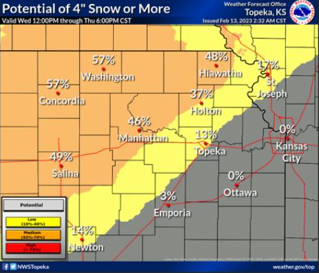
13% chance of 4 inches of snow or more predicted for Topeka
The storm is expected to move late Wednesday and Thursday across the central plains, according to the weather service.
"Confidence is increasing for several inches of snow combined with strong, gusty winds to create blowing snow and hazardous travel," it said.
The Accuweather website predicted the storm would most likely bring Topeka "an inch or two" of snowfall, or less.
The weather service graphic estimated the chance for 4 or more inches of snow would be 57% at Washington and Concordia, 49% at Salina, 48% at Hiawatha, 46% at Manhattan, 37% at Holton, 17% at St. Joseph, Mo., 14% at Newton, 13% at Topeka, and 3% at Emporia.
It indicated the chance for at least 1 inch of snow would be 87% at Washington, 86% at Concordia, 83% at Salina, 82% at Hiawatha, 80% at Manhattan, 79% at Holton, 76% at St. Joseph, Mo., 69% at Topeka, 65% at Newton, 53% at Emporia, 43% at Kansas City, Mo., and 40% at Ottawa.
More:How to check Kansas road conditions, maps and see highway images
Cold weather season has brought Topeka less snow than usual
Winds were forecast to come from the north and gust at 41 mph at Hiawatha, 39 mph at Holton, 36 mph at Topeka and 35 mph at Manhattan.
The precipitation could initially begin as rain before changing to snow as colder air moves in, the weather service said.
Storm probabilities have moved further south since the oncoming storm was first detected but the storm track may still shift, which would change the location of the anticipated heaviest snow, the weather service said.
Topeka has recorded 3.65 inches of snow so far this cold weather season, according to figures posted on the website of the Topeka weather service office. Topeka's average snowfall by Feb. 13 is 12.1 inches.
Contact Tim Hrenchir at threnchir@gannett.com or 785-213-5934.
This article originally appeared on USA TODAY: Storm expected to bring snow Wednesday to north-central, NE Kansas
