
4 disturbances in the Atlantic have tropical-storm potential for NC. What we know now
After a relatively quiet Atlantic hurricane season so far this year, as of Friday morning there were four disturbances in the basin with the potential to become tropical storms.
The most recent update from the National Oceanic and Atmospheric Administration shows that none of the four poses an imminent threat to the U.S. coast, including North Carolina, but NOAA is watching to see how each one develops over the next several days to a week.
The sudden flurry of activity is not unexpected; though the Atlantic hurricane season runs from June 1 to Nov. 30, NOAA says most storms happen from mid-August to mid-October. So far this year, there have been three named tropical storms and one hurricane in the Atlantic: Arlene, Bret and Cindy in June, and Don in July.
NOAA has revised its hurricane forecast
Last week, NOAA updated its prediction for the 2023 season and is calling for an “above normal” level of storm activity because of record-high temperatures in ocean surface waters. Those temperatures are likely to offset the hurricane-suppressing effects of an ongoing El Niño.
Including storms that have already occurred this season, NOAA now forecasts: 14-21 named storms (with winds of 39 mph or greater), of which six to 11 could become hurricanes (with winds of 74 mph or greater). Of those, two to five could become major hurricanes (with winds of 111 mph or greater). NOAA forecasters say they have 70% confidence in those ranges.
The next named storm would be Emily.
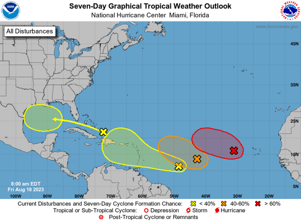
Here are the four systems:
A low-pressure system in the eastern tropical Atlantic, several hundred miles west of the Cabo Verde Islands. NOAA says the system is likely to develop into a tropical depression over the weekend as the system moves west-northwest, but upper-level winds over the system are likely to prevent it from becoming a tropical storm.
An elongated low-pressure system in the central tropical Atlantic, between the Cabo Verde Islands and the Lesser Antilles. NOAA says this one is producing showers and thunderstorms and could become a tropical depression over the weekend, but upper-level winds are likely to prevent it from developing further.
Several hundred miles east-southeast of the Lesser Antilles is a trough of low pressure NOAA says could develop into a more organized system as it moves west-northwest toward the Caribbean over the weekend and into next week.
In the Greater Antilles, a disturbance just north of Hispaniola is expected to move into the Gulf of Mexico by early next week. There, NOAA says, it could develop into a broad area of low pressure and possibly become more organized as it moves toward the Gulf Coast by mid-week.
Jim Cantore weighs in
Weather Channel meteorologist and noted storm-chaser Jim Cantore shared the NOAA map on platform X (formerly Twitter) Friday, saying he was most interested in the system closest to the lesser Antilles. “Interesting latter part of August coming up,” Cantore wrote.

