
Up to 60 cm of snow bears down on northern Ontario, snow squalls for south
A moisture-laden winter storm sweeping through Ontario will bring disruptive snow to the northern portion of the province into and over the weekend, with up to 60 cm of fresh snow possible north of Lake Superior.
Folks across southern Ontario will fall on the warmer side of this system, for once, with a steady and soaking rainfall on tap for St. Patrick’s Day.
DON’T MISS: Ontario just lived through its darkest winter in 73 years
A vast low-pressure system moving into the Great Lakes will drag plenty of moisture north of the border. Storms in the early spring months can produce enhanced snowfall as they tap into a deep reserve of tropical moisture flowing up from the south and west.
That touch of evaporated paradise streaming in from as far away as Hawaii and Mexico will fall over Ontario in abundance over the next couple of days.
Widespread winter storm warnings are in effect for a swath of northern Ontario as a long-duration snow event that began Thursday will bring significant accumulations to the region through Saturday.
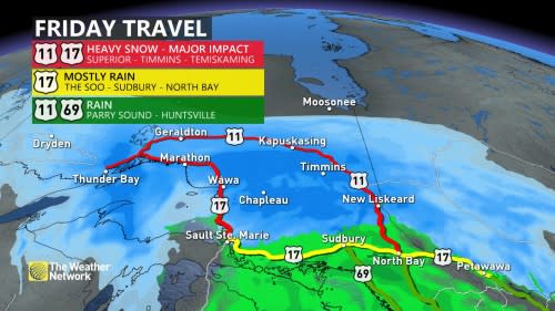
“Snow may quickly accumulate and visibility may be significantly reduced at times,” Environment and Climate Change Canada (ECCC) said in its winter storm warning for the region, including the communities of Timmins and Thunder Bay.
“Significant travel delays and road closures may occur,” ECCC added. "Consider postponing non-essential travel until conditions improve."
Locally strong winds between 70-80 km/h and snow will lead to whiteout conditions for roads and communities along the north and eastern shores of Lake Superior through Friday.
The track of this low-pressure system will place the deepest snows northeast of Lake Superior, with 40+ cm of snow possible in Timmins, Kapuskasing, Chapleau, and Wawa. The forests between these communities could see up to 60 cm of snow, or about as much snow as two corgis stacked on top of one another. (Please don’t try this at home.)
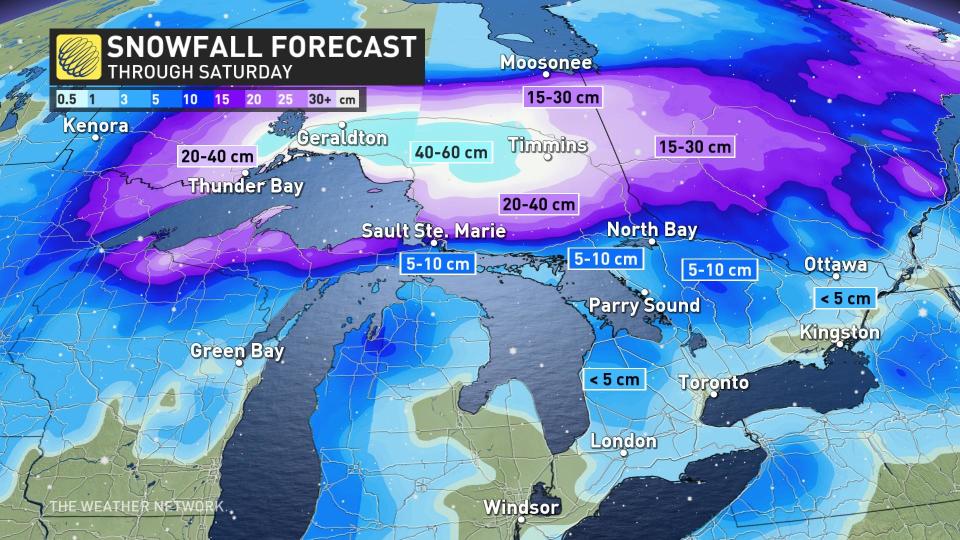
A formidable blanket of 20-40 cm of snow is likely farther west along the Superior shores toward Thunder Bay. Farther south, however, snowfall totals are trending down as the track of the storm trends north.
Sault Ste. Marie and Sudbury will see snow that changes over to rain at the beginning of the storm, then rain changing back to snow at the end of the storm. The combined total of these two rounds of snow will add up to about 5-10 cm in each community, with totals quickly climbing to the north and rapidly falling off toward the south.
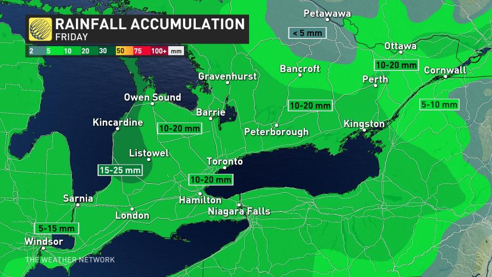
A warm front dragging along the southern side of the low will keep things warm enough for precipitation to remain all-rain at first in southern Ontario. Widespread rainfall totals of 10-20 mm are possible through Friday, with 15-25 mm of rain possible along the Huron shores.
This rain shouldn’t be a big deal on its own, but ponding on roads and parking lots is possible in spots where storm drains are still clogged with snow.
WATCH NOW: Travel hazards due to snow squalls in Ontario
DON'T MISS: Ontario’s historical chances of snow on St. Patrick's Day
Friday’s surge of milder temperatures will prove short-lived, unfortunately, as a cold front following soon behind will send temperatures falling again in a hurry Friday night into Saturday.
The push of colder air blowing over the largely ice-free lakes will lead to the potential for lake-effect snow squalls across southern Ontario on Saturday and Sunday.
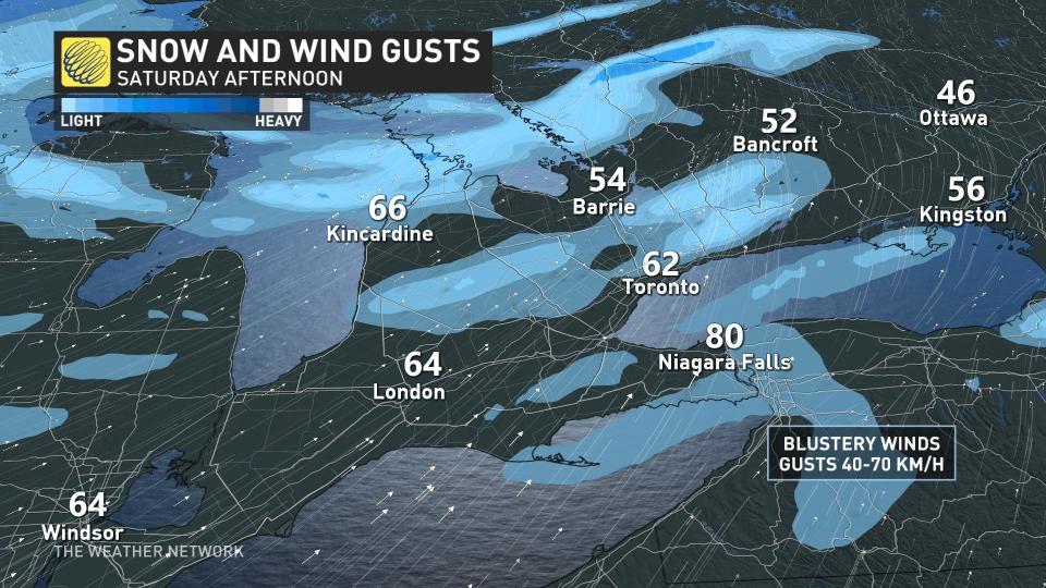
Gusty winds of 40-70 km/h will accompany this weekend’s snow squalls, creating reduced visibility during times of heavy snow and blustery conditions. Visibility can change rapidly over short distances around snow squalls. Travellers should prepare for hazardous driving conditions, especially with additional traffic on the roads as folks return home from March break.

Beyond this system, fairer weather will greet Ontario to begin the new workweek, with calmer conditions and near-seasonal temperatures expected to prevail as astronomical spring arrives on Monday. Forecasters are watching the potential for another system to arrive in the latter half of the week.
Stay with The Weather Network for the latest on conditions across Ontario.

