
Accumulating snow coats B.C.'s South Coast, makes travel arduous
It’s been a couple of months since we’ve seen this kind of snowfall across the South Coast, so residents should expect more travel disruptions Sunday morning and brace for post-storm cleanup accordingly.
MUST SEE: Ice falls in Hollywood as wild setup fans Calif. blizzards, historic heat
A moisture-laden low-pressure system sliding down the coast met up with Arctic air flowing out of the Interior to lay down a blanket of snow across much of the South Coast.
The snow will ease early Sunday morning, but travel and power disruptions are likely to continue through the day, especially across the mountain passes and on untreated side roads.
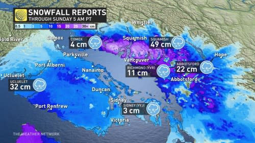
Some hefty snowfall totals have already been reported as of 5 a.m. PST Sunday. Squamish, B.C., is clearly the winner so far, reporting a whopping 49 cm. Port Mellon isn't far behind, though, with 41 cm observed.
Ucluelet, situated on western Vancouver Island, has seen 32 cm. Surrey and Whistler have documented 27 cm, Abbotsford has recorded 22 cm and 11 cm has fallen at Vancouver International Airport.
Adding to the travel issues are the power outages, with BC Hydro reporting more than 20,000 customers in the dark so far, and that figure may continue to climb as the day progresses.
Environment and Climate Change Canada (ECCC) issued snowfall warnings for all of the Lower Mainland, including Metro Vancouver, through Sunday morning.

“Prepare for quickly changing and deteriorating travel conditions,” ECCC said in its warning. “Rapidly accumulating snow will make travel difficult.
We could see 15-25 cm of snow across Metro Vancouver by the end of the storm, with totals reaching over 25 cm across higher terrain.
Totals will vary across Greater Victoria with locally over 15 cm towards the West Shore communities and across the Malahat.
Snow will taper off to wet snow flurries and localized showers through Sunday for the South Coast and Vancouver Island. Some of these heavier showers may contain small hail, as they will be convective in nature.

DON'T MISS: Jet streams can bring Canada wild winters and steamy summers
Behind the storm, temperatures will slowly warm across the South Coast heading into this week, though near to below-seasonal temperatures are likely to stick around through at least the first few days of March.
Another round of unsettled weather will arrive early this week, bringing the potential for rain and snow across the region. We're watching Monday evening for another swath of wet snow to cross portions of Vancouver Island and the Lower Mainland as a low moves in from the south.
WATCH: Snow causes problems on the B.C. South Coast
*Thumbnail courtesy of Norman Dick, taken in Sicamous, B.C.
Be sure to check back for the latest forecast for B.C.

