
New system to follow Lee's dousing on Atlantic Canada with more rain
Another system will swiftly follow Lee this week, targeting eerily similar locations in the Maritimes with heavy rainfall, albeit a little farther northwest.
PHOTOS: Thousands left in the dark in the Maritimes after Lee's wrath
Some of the areas hit hard by Lee could see another deluge, with the potential for another 30-60 mm of rainfall. With the combination of additional gusty winds and rain-soaked soils, that could be enough to cause further tree and power line damage, on top of what Lee produced over the weekend.
Tuesday and Wednesday
Areas: The Maritimes and Newfoundland
Timing: Early Tuesday through late Wednesday
Weather:: There is confidence for high rainfall totals in northern New Brunswick and the Gaspé Peninsula -- regions that were hit the hardest with Lee’s rains already. Gaspé recorded 107.6 mm of rainfall on Saturday, officially the rainiest September day on record and eighth rainiest day in history.
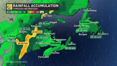
The rain will start in the pre-dawn hours Tuesday for the Maritimes and continue all day before easing late-night, but some showers could last for northern New Brunswick and in Gaspé for early Wednesday. Newfoundland will see the rain start in southwestern areas late Tuesday, then engulfing the island overnight before the rain moves out late Wednesday.
DON’T MISS: A rare behemoth: Hurricane Lee’s incredible 9,000+ km journey
Winds are expected to be near 40-70 km/h during the event.
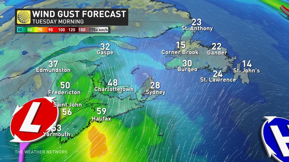
The combination of additional gusty winds and rain-soaked soils could be just enough to add tree and power line damage on top of what Lee produced over the weekend.
Thumbnail courtesy of Getty Images-1476190237.
Stay with The Weather Network for the latest on conditions across the Maritimes.

