
Wild temperature seesaw accompanies next storm risk across Ontario
You’ll probably go through your entire wardrobe over the next seven days trying to keep up with the kaleidoscope of conditions about to sweep across Ontario.
Temperatures are on the downswing heading into Sunday after a warm start to the weekend saw heavy rain and even a couple of severe thunderstorms roll through southern Ontario.
We’re looking ahead to the next storm potential arriving by midweek, potentially arriving with more thunderstorms and even warmer temperatures.
DON'T MISS: Will spring's sluggish start continue through April? Your monthly forecast, here
The system that brought heavy snow to the north and thunderstorms to the south left an even greater mark south of the border, with a high-end severe storm outbreak on Friday rolling into a second impactful day of storms along the Interstate 95 corridor between Washington and New York City.
GET THE LATEST: Death toll nears 20 as severe storms take aim at eastern U.S.

The storm responsible for the destruction down south and unsettled weather here in Ontario will finally ease as the system lifts north and east.
A risk for flooding persists into early Sunday across parts of southern Ontario. Flood warnings remain in effect along the Grand River, including Cambridge, Brantford, North Dumfries, and Brant County. Stay alert for the potential for flooding along and near the river.
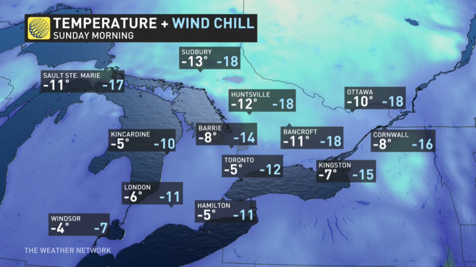
Much chillier temperatures are filtering in on northwesterly winds behind the storm. Temperatures will dive below freezing for most of the region by Sunday morning, with winds pushing feels-like values into the negative double-digits for some areas.
Temperatures over the next couple of days will seesaw between above- and below-seasonal, with warmer temperatures on Monday giving way to cooler conditions on Tuesday.
WATCH: Thunderstorms and flooding start the month across southern Ontario
SPRING SAFETY: 5 all-natural products to keep ticks at bay
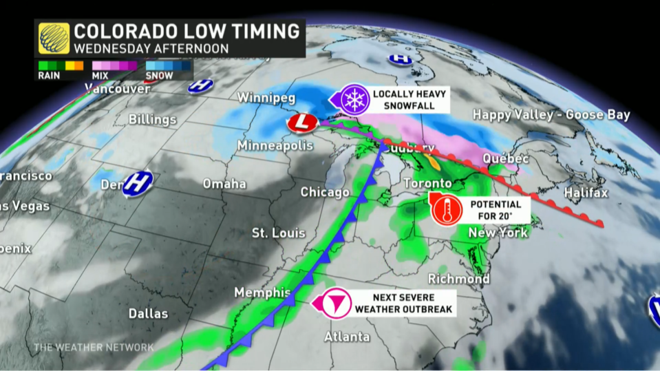
Wednesday is the next day to watch across Ontario as forecasters monitor the development of a potential Colorado low tracking toward the Great Lakes region.
Depending on the track of this midweek system, southern Ontario could see even warmer temperatures and the potential for another around of rain and thunderstorms.
Someone in southern Ontario could see the 20-degree mark on Wednesday, which would be the first time we’ve seen that benchmark of warmth anywhere in Canada so far in 2023.
Be sure to check back for the latest weather updates across Ontario.

