
Arctic cold front to hit WA. Snow possible in Tri-Cities and heavy in the mountains
Update: The National Weather Service no longer expects snow in the Tri-Cities Saturday associated with an Arctic cold front. But temperatures could drop as low as 12 degrees in the coming nights.
---------------------------------------
The Tri-Cities could see some snow and temperatures dipping into the teens this weekend as an Arctic cold front moves over the Pacific Northwest, says the National Weather Service.
It also is warning travelers over the Cascade or Blue mountains to be prepared for snow and much colder temperatures.
The Tri-Cities will be under an air stagnation advisory until 3 p.m. Friday, which could affect air quality, before the cold front arrives.
As temperatures cool from a forecast high of 49 to 37 on Saturday, precipitation may fall as snow.
The weather service predicts a 50% chance of rain before 10 a.m. Sunday, turning to rain or snow through the afternoon and early evening. Wind gusts up to 25 mph are forecast.
Less than half an inch of snow is expected to accumulate, with snow most likely at 600 feet and above, which would be at the highest elevations in the Tri-Cities.
The cold front will bring breezy to windy conditions beginning Sunday that could cause “very cold wind chills” in Washington and Oregon through the first half of next week, the weather service said.
Temperatures in the Tri-Cities could fall to 10 to almost 20 degrees below normal.
Overnight lows in the Tri-Cities are expected to drop from just above freezing Thursday night to as cold as 12 degrees on Sunday night, 13 degrees on Monday night and 17 degrees on Tuesday night.
Highs are expected to drop into the 20s from Sunday through Tuesday in the Tri-Cities, with the coldest day forecast to be Monday with a high of 25.
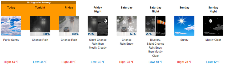
Normal highs for late January in the Tri-Cities area bout 44 and normal lows are about 28.
Mountain travel forecast
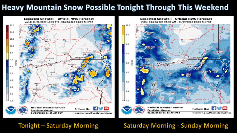
Snow could be heavy at times in the Cascade Mountains of Washington and Blue Mountains of Washington and Oregon in the coming days, with up to a foot of snow at the higher peaks, according to the weather service.
The first part of the forecast storm system could bring some snow to the mountains through Saturday morning, with the main cold front bringing more snow Saturday through Sunday.

Check the Washington state Department of Transportation mountain pass report at wsdot.com/travel/real-time/mountainpasses for current conditions and restrictions.
A mix of rain and snow was forecast through Friday night on Snoqualmie Pass on Interstate 90, possibly making the road slick at times.
An inch of snow was forecast for Thursday night, 1 to 3 inches on Friday and another inch Friday night.
On Saturday, gusty winds and 3 to 5 inches of new snow falling could reduce visibility on I-90. Sunday should be sunny and dry.
Snow is likely on Highway 12 across White Pass Friday and Saturday. Friday 1 to 3 inches is forecast and Saturday 2 to 4 inches are forecast.

The temperature in the Blue Mountains at Meacham 30 miles east of Pendleton on Interstate 84 could drop to -6 on Sunday and Monday nights.
Travelers on I-84 should be prepared for 3 to 5 inches of new snow Friday, 1 to 2 inches Friday night, 3 to 5 inches Saturday and 1 to 2 inches Saturday night before skies start to clear on Sunday.

