
Bad news, Canada: 'Severe' summer weather is on the way
Many Canadians spend most of the year longing for the warm summer months, but forecasters are predicting some drastic differences and severe weather patterns throughout the country this season.
Western Canada is already off to a dangerously hot and dry start with thousands being evacuated from parts of B.C. and Alberta. Most recently, individuals in communities near Mackenzie County, including the High Level area north of the Peace River, were given an evacuation order this week, with the fire now covering over 300,000 hectares of land.
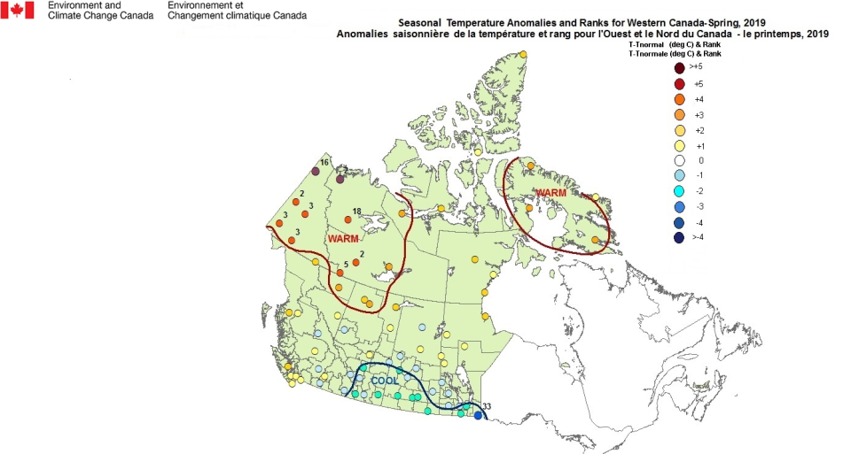
“In B.C.’s case, on the coast Comox, in the southern interior Kelowna...Prince George and on the border between the Yukon and B.C. Watson Lake, all had their driest spring on record,” Armel Castellan, warning preparedness meteorologist with Environment Canada told Yahoo Canada. “The longest [period of record] is Comox and it goes back to 1895. That’s only 34% of normal precipitation during those three months...that’s 74 mm fallen when they should have seen 215 mm.”
Throughout the rest of the summer season, weather experts are not expecting these conditions to improve. Residents in B.C.and the most western parts of Alberta are expected to be dominated by hot days with few chances for precipitation in sight.
“We are concerned that this is a sign of things to come for the rest of the summer with a higher than typical threat for wildfires and smoky conditions,” The Weather Network wrote in their summer forecast about the B.C. area.
Prairies
The Prairies will be stuck between the hot and dry conditions in B.C. and western Alberta, and cooler and wetter conditions in Ontario. But forecasters aren’t exactly on the same page with what people in the area can expect throughout the summer season.
According to The Weather Network, much of Alberta, Sakatchewan and Manitoba are expected to have near-normal rainfall amounts with areas in Alberta, north of Edmonton, having the highest threat of being drier than normal. AccuWeather is predicting a “extreme drought” situation for the region this summer.
“Currently, significant drought exists in portions of northwestern British Columbia, northern Alberta and from south-central Saskatchewan to south-central Manitoba,” Brett Anderson, senior meteorologist with AccuWeather said in a statement.
According to Castellan, the certainty surrounding Environment Canada’s summer forecast decreases as we move east throughout the Prairies.
“The probability is above normal temperatures for certainly western Canada, B.C. in particular and edging towards Alberta, Saskatchewan and even Manitoba, and then kind of decreasing probabilities as you go through the Prairies,” Castellan said. “The confidence with that seasonal forecast is less in Manitoba as it is on coastal B.C.”
Ontario and Quebec
Wetter conditions in Ontario will bring cooler temperatures to the region this summer, with active storm patterns on the horizon.
The Weather Network believes these conditions will bleed into Quebec as well, while AccuWeather predicts the province will see more typical summer warmth.
“A humid and changeable summer is expected across most of this region with less extreme heat compared to last year,” The Weather Network indicated in their forecast. “An active and stormy pattern is expected to continue well into the summer with a heightened risk for thunderstorms and severe weather, especially flash flooding.”
According to Environment Canada, southwestern Ontario, up almost into James Bay and over into the lower third of Quebec, is expected to have a colder than normal summer. But the confidence is only at about 50% at this point.
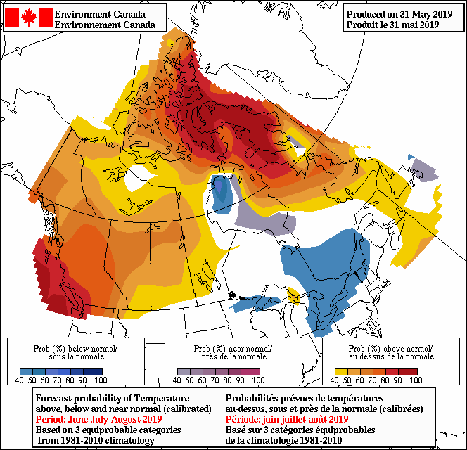
“In these kinds of forecasts, when the signal isn’t very strong you have an equal chance of any of the three categories, being below, near or above normal,” Castellan said. “That does exist in this case for northwestern Ontario and the whole central part of Quebec, including Gaspesie and New Brunswick.”
According to Environment Canada, he populated zone of Sarnia over to Quebec City are projected to have “fairly cool, if not near normal or colder than normal” temperatures for June, July and August. This follows significant flooding around the national capital region in late-April and May.
Maritimes
The drier conditions pick back up in the Maritimes, with short-term drought concerns in some areas, according to The Weather Network, but a sentiment that AccuWeather is relatively in line with.
“A more persistent west to west-northwesterly wind flow pattern should limit the amount of Atlantic moisture into the region, leading to more sunshine than usual,” Anderson said in a statement.
Warmer temperatures will dominate throughout the region this season, while coastal areas will be a bit cooler.
“Mostly the very eastern parts of Nova Scotia and Newfoundland will have also above normal trend for seasonable forecast but it’s a very weak signal so in a way it’s a little bit closer to a near normal just because it’s between 40% and 50%,” Castellan said.

