
Bad news for hurricane season: La Niña chances grow more certain, NOAA says
Climate troublemaker La Niña isn't here yet – but it is on the way, federal weather forecasters said in a report released Thursday morning.
In fact, forecasters from the National Oceanic and Atmospheric Administration gave the climate pattern as much as an 85% chance of forming by late fall. "We are very confident that La Niña will form by this fall," Nat Johnson, a NOAA meteorologist, told USA TODAY. Once it forms, it's also supposed to last through next winter and would impact U.S. weather throughout the coldest months.
Of more immediate concern, there's also as much as a 69% chance it will develop by the summer months (July-September), NOAA said. This is key because a full-fledged La Niña could worsen the severity of the Atlantic hurricane season, the heart of which is typically in September.
What is La Niña?
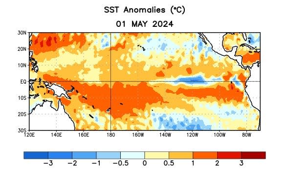
La Niña is a natural climate pattern marked by cooler-than-average seawater in the central and eastern Pacific Ocean. When the water cools at least 0.9 degree Fahrenheit below average for three straight months, a La Niña is declared.
Surprisingly, that small amount is enough to affect weather and climate patterns in the U.S. and around the world.
Get ready to hear a lot about La Niña. Here's why it could make hurricane season worse.
The cycle between La Niña and its "sibling" El Niño is hugely important for agriculture worldwide. El Niño generally brings wetter conditions to the Americas, while a La Niña has the opposite effect.
Is El Niño over?
Not yet, it's technically still in effect but is fading fast, soon to be replaced by what's known as "ENSO-neutral" conditions, which is an intermediate stage between La Niña and El Niño. NOAA's forecast "favors an imminent transition to ENSO-neutral conditions, with La Niña developing during July-September 2024 and then persisting through the Northern Hemisphere winter."
The entire natural climate cycle is officially known by climate scientists as the "El Niño – Southern Oscillation" (ENSO), a see-saw dance of warmer and cooler seawater in the central Pacific Ocean.
Is this an unusually slow transition from one to the other?
"Actually, this transition appears to be occurring rather quickly," Johnson told USA TODAY. "We are unlikely to experience many seasons of ENSO-neutral conditions before the onset of La Niña, whereas on some other occasions we may experience more than a year before transitioning to La Niña."
"The strength of the El Niño is likely a major factor for why this transition is fast," he added. "It’s not unusual for strong El Niños to transition quickly to La Niña, as the discharge of heat away from the tropical Pacific tends to be more dramatic following a strong El Niño."
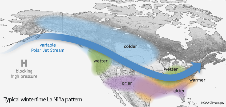
What is a La Niña winter?
Forecasters are calling for La Niña to continue throughout next winter. A typical La Niña winter in the U.S. brings cold and snow to the Northwest and unusually dry conditions to most of the southern tier of the U.S., according to NOAA's Climate Prediction Center. The Southeast and Mid-Atlantic also tend to see warmer-than-average temperatures during a La Niña winter.
This article originally appeared on USA TODAY: La Niña 2024: New forecast from NOAA is bad news for hurricane season

