
Big temperature swing to test Ontario’s patience this week

Spring is a famously temperamental season and it’ll certainly live up to that reputation this week across Ontario as an active pattern builds over the Great Lakes.
Several systems moving through the region will send temperatures rising above seasonal on Monday, only to crash down late Tuesday with readings that may again threaten the long-anticipated cherry blossoms.
Conditions will gradually warm again by the end of the week, marking the end of an unsteady temperature trend that truly resembles the silhouette of a roller-coaster.
DON’T MISS: Destructive wall of ice crushes cabins, damages properties
Monday: A short-lived warmup arrives
We felt the first temperature dip this weekend as cooler air and blustery conditions swept into the region. That pattern is on its way out in a hurry as the next system arrives.
A low-pressure system sliding in from the eastern Prairies will send a warm front lifting across southern Ontario through the day Monday.
Sunny skies and a warm southerly breeze will push daytime highs into the mid-teens for folks across far southwestern Ontario, including a cozy 17°C high in Windsor. Temperatures will remain in the upper single digits throughout the Greater Toronto Area and up toward Ottawa.
This warmer air is on borrowed time. A cold front cutting across Ontario will send readings plummeting in its wake. Folks in northern Ontario will see a pronounced temperature drop on Monday, with a rapid cooldown expected in communities like Timmins and Thunder Bay.
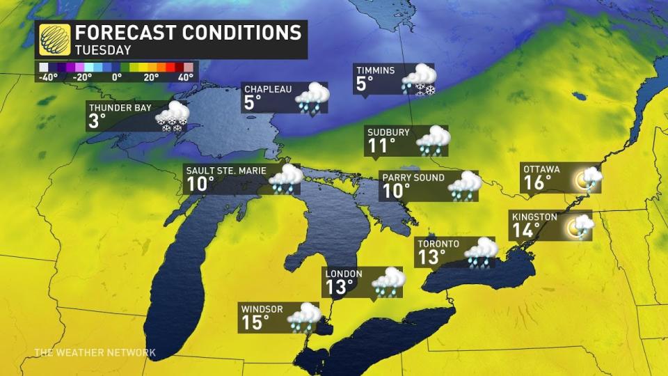
Tuesday: Even warmer in the south ahead of the cold front
Clouds and showers will build over southern Ontario on Tuesday as the low-pressure system approaches the area.
MUST SEE: Extreme pattern over Arctic produces 50+ degree temperature spread
Stiff southwesterly winds approaching 70 km/h will allow temperatures to rise into the teens as far north as cottage country, with Ottawa topping out at 16°C and Sudbury even rising above the 10-degree mark.
That sharp cold front will make its presence known as it digs into the region.
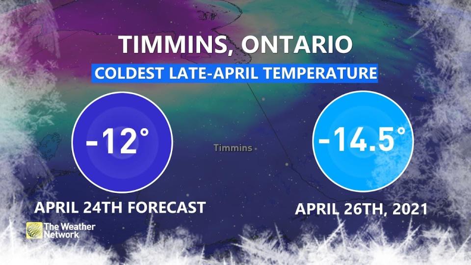
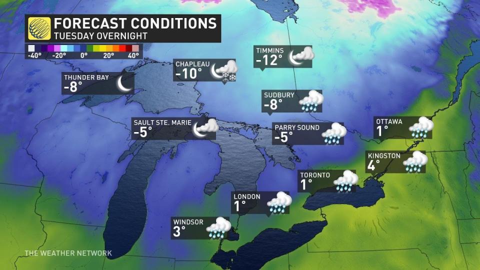
Tuesday night is on track to be remarkably chilly up north. Timmins is expected to dip to -12°C on Tuesday night, which is just a couple of degrees above the coldest temperature we’ve ever seen this late into the year.
Cold air will settle over all of Ontario through Tuesday night, with subfreezing lows expected throughout cottage country and along the Huron shores. Folks along the Highway 401 corridor will see nighttime lows bottom-out in the lower single digits.
Forecasters are watching the potential for a wintry mix to develop early Wednesday for parts of southern Ontario. Keep checking back into the day Monday for more on that potential.
Looking ahead, an additional round of unsettled weather is likely toward the end of the week and into next weekend. We’re stepping off the temperature roller-coaster, though, as this pattern will favour more consistently mild readings—along with a threat for potential thunderstorm activity in spots.
Header image courtesy of Getty Images.
Stay with The Weather Network for the latest on your forecast across Ontario.

