
Wild weekend weather causes storm damage, flash flooding

The heatwave in Eastern Canada may have eased this weekend, but the storms that heralded the end of the hot, humid weather in Ontario and Quebec weren't finished, as they caused even more damages through New Brunswick on Saturday night.
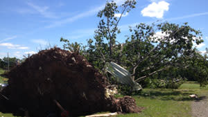
Environment Canada officials in New Brunswick are investigating reports of a possible tornado today after a powerful storm tore through east of Fredericton. While the weather service can't confirm whether or not a tornado is actually to blame without surveying the damage site in person, Alex Haché captured video that makes a convincing argument that a twister was involved at least somewhere in the storm.
The cold front that spawned the storms was also responsible for stormy weather over Ontario and Quebec last week, where some are still waiting for their power to be restored.
[ Related: Power outages still plague Ontario, Quebec after storms ]
The Maritime provinces can look forward to more moderate temperatures this week, but the change in air mass comes with a price to pay for some. Whether or not Environment Canada confirms a tornado is to blame, numerous residents in central New Brunswick will have to waste at least a little of the nicer weather doing some major clean-up.
Here's a downed 60-y-o maple that took out some power lines next to a barn that collapsed in Whites Cove. #nbstorm pic.twitter.com/oITjtm3LBa
— Colin McPhail (@colinmcphail) July 21, 2013
Residents of the Prairies had their own storms to deal with over the weekend, including at least one tornado touchdown in southwestern Manitoba on Sunday.
Tornado! #weathernetwork #manitobastormwatch pic.twitter.com/32uDAxu2wY — Janelle (@JanelleDawn19) July 22, 2013
Another cold front was to blame for the severe storms that sprung up across southern Alberta on Saturday, and Saskatchewan and Manitoba on Sunday; not at all an uncommon location for such storms in mid-July. Each year, an average of about 43 tornadoes occur across the Prairies, and July is smack dab in the middle of the peak season for them.
The front first sparked storms in Alberta, generating heavy downpours and large hail, as snapped by storm chaser Braydon Morisseau.
More pictures of hail in Red Deer, Alberta #abstorm pic.twitter.com/AparnEIFIe
— Braydon Morisseau (@BraydonMoreSo) July 21, 2013
Storm chasers and weather enthusiasts were out in force, capturing the storms' progress across southern Manitoba on Sunday.
Another shot from today's tornado warned storm near Souris, MB. #MBstorm pic.twitter.com/6j2MTGjF6j — Sean Schofer (@SeanSchoferTVN) July 22, 2013
@weathernetwork. South of deloraine. #turtlemtn pic.twitter.com/BRfBRjbMXY
— Curt Lesy (@curtlesy) July 22, 2013
Not very often you see a webcam catch a lightning bolt! Current view looking to downtown #winnipeg #mbstorm pic.twitter.com/IvqnpGRjnC — Rob's Obs (@robsobs) July 22, 2013
[ More Geekquinox: Multiple deaths and injuries as strong earthquakes rattle western China ]
While some Manitobans encountered localized flooding with their storms, heavy rains wreaked havoc well south of the border in Arizona. Several parts of the state, including Canadian snowbird-favorites Phoenix, Scottsdale and Tucson, were drenched over the weekend by storms that triggered flash flooding.
New wave of rain starting in #Phoenix metro area. Streets, freeway, airport all were closed for period of time. #azxw pic.twitter.com/SqBLeAkChQ
— Michael Meister (@photomeisterAZR) July 21, 2013
Flash flooding isn't uncommon at this time of year for the Grand Canyon State, as July marks the return of the North American monsoon in the southwestern U.S.
Geek out with the latest in science and weather.
Follow @ygeekquinox on Twitter!
