
New Brunswick weather: Heavy rainfall, snowfall warnings
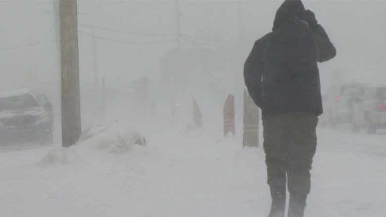


Weather warnings remain in place for the northeast and southeast areas of the province as the first winter storm of the season moves through New Brunswick.
At midday Monday, snowfall warnings were in place for an area stretching from Miramichi to Mount Carleton to Bathurst and the Acadian Peninsula.
In southern and southeast New Brunswick, rainfall warnings were active for Saint John, Sussex, Moncton and southeast New Brunswick.
Warnings that had been in place earlier for other parts of the province were ended.
The storm knocked out power briefly to more than 4,500 NB Power customers and closed schools in the northeast of the province.
NB Power was reporting 4,545 homes and businesses without power as of 10 a.m., but that number had fallen to 327 by 12:30 p.m.
At the peak, most of power problems were caused by a transmission outage that affected 3,600 homes and businesses from Nackawic to Lake George, tweeted NB Power.
As of 12:30 p.m., the Miramichi area had 167 outages and the Fredericton area had 114 customers without electricity.
Smaller outages were reported in Rothesay, Shediac and Woodstock.
Some schools close
The Anglophone North School District has closed schools in Bathurst, Miramichi and Rexton.
The Francophone South School District has cancelled classes at Carrefour Beausoleil in Miramichi. Baie-Ste-Anne, Rogersville, St-Louis-de-Kent and Richibucto.
Police and fire departments were also using social media on Monday to warn drivers to take their time in their morning commutes.
New Brunswick's Emergency Measures Organization also tweeted reminders to motorists to drive according to road conditions.
CBC meteorologist Peter Coade said the system will bring 60 to 100 millimetres of rain across the region on Monday, with snow in northern parts of the province.
"However, where this precipitation falls to the cold side of this line over the northwestern half of New Brunswick, it falls as snow," said Coade.
Coade said communities in southeastern New Brunswick which will receive rain Monday morning and see it change to snow as the temperatures start to fall.
"There is also the risk of freezing rain and likely ice pellets along and close to this line," he said.
"If my figuring is correct, as this trough line moves to the east pulling the cold air behind it, the rain will end in Prince Edward Island and Nova Scotia before the temperatures fall sufficiently to change rain to snow. Thus only New Brunswick will see any significant amount of snow."
Some communities could see as much as 15 to 20 centimetres of snow.
New Brunswick EMO advised that the significant rainfall in the forecast for southeastern New Brunswick could lead to localized flooding, particularly where normal drainage systems are overwhelmed.
In the wake of this stormy weather, an area of high pressure will build into the Maritimes from the west for the balance of the week, said Coade, with sunny days and mainly clear nights.
"This return to fair weather will start overnight [Monday] as the sky becomes mainly clear and temperatures fall," he said.
Temperatures will be considerably milder than the normal Monday, but will fall during the day to considerably colder than normal for Tuesday and Wednesday.
New Brunswick forecast
There is a snowfall warning in place for northern New Brunswick on Monday.
The day will be cloudy with snow, heavy at times, and occasionally mixed with rain in the east this morning and tapering to flurries Monday afternoon before clearing.
Snowfall amounts are expected to be between 10 cm and 25 cm. The wind will gust to 40 km/h on Monday morning, with a high steady, or falling slowly, to –4 C with a windchill near –10 C.
Monday night will see partly cloudy skies in the north, with the chance of flurries ending on Monday evening, then clearing with wind out of the northwest gusting to 40 km/h and a low of –8 C to –6 C.
For the Fredericton area, there is also a snowfall warning for Monday.
Skies will be cloudy with rain, changing to snow, heavy at times with amounts between 10 cm and 15 cm, and wind from the north gusting to 40 km/h and a high steady near 0 C.
On Monday night, expect mainly clear skies with wind northwest gusting to 40 km/h with a low near –6 C.
In southern New Brunswick, there is a rainfall and a snowfall warning in place.
For Monday, the extreme west will see rain, heavy at times, changing to snow before ending.
The Saint John to Sussex area will see rain, heavy at times, changing to ice pellets and flurries with the risk of freezing rain Monday afternoon.
East of Sussex, will see rain, heavy at times, changing late this afternoon to ice pellets and flurries with the risk of freezing rain with further rainfall amount between 50 mm and 70 mm and snowfall amounts between 10 cm to 15 cm.
The temperature will be near zero.
Monday night will be cloudy in the south, with flurries ending in the evening, then becoming mainly clear with wind northwest gusting to 40 km/h and a low between –6 C and –4 C.
