
Bryan Norcross: Texas, Mexico watching and waiting for Hurricane Beryl
UPDATED Thursday at 11 a.m. ET
The core of Hurricane Beryl has moved past the Cayman Islands and the weather will slowly improve there today. Through the rest of today and tonight, the hurricane will be tracking across the open western Caribbean.
The official National Hurricane Center forecast calls for the storm to weaken during this time because the computer forecast models show Beryl moving through a hostile environment of strong headwinds and dry air.
There are questions, however.
First, the water in the western Caribbean is extraordinarily warm so there's a lot of energy for the storm to build thunderstorms to fight back against the dry air. Second, normally, the east-to-west winds blowing across the water relax in the western Caribbean, which supports storms strengthening there. Third, Beryl fought off the dry air and strong winds yesterday, and its core is still intact after taking a battering.
An intact core means the system can more easily re-intensify if the hostile conditions relax.
Computer forecast models are our best tools for predicting what a storm will do, but being aware of other factors tells us that there is some uncertainty about how strong Beryl will be when it gets to the Yucatán.
Everyone on the Caribbean side of the Yucatán Peninsula, including the large resort cities of Cancun, Cozumel, and Tulum, should pay close attention to local emergency information. The weather will deteriorate later today, with the greatest impact from Beryl coming overnight.
The hurricane is likely to weaken as it passes over the Yucatán landmass. The center will emerge in the Gulf of Mexico late tomorrow. The National Hurricane Center forecast predicts Beryl will weaken below hurricane strength when it's over land. If the storm takes a northward jog, however, like it did yesterday, it will pass over less land before getting to the Gulf.
The predicted upper-level winds over the Gulf appear reasonably conducive for Beryl to strengthen, although there will still be dry air. By then, its forward speed will have slowed significantly, so there may well be time for Beryl to regain hurricane status. We need to be ready for the storm to be stronger than the Category 1 that is forecast.
A rule of forecasting says that slow-moving storms have larger errors in their forecasts. Be ready for this rule to apply to Beryl in the Gulf.
The consensus of the computer forecast models is that the center of Beryl will come ashore near the Mexico/Texas border, plus or minus. If that's correct, there would be significant impacts in South Texas: gusty winds, heavy rain, and storm surge along the coast. That's the same coastline that was impacted by circulation around Hurricane Alberto earlier this year.
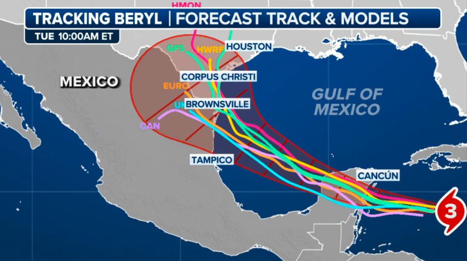
The storm is likely to arc north to one degree or the other in the Gulf because a dip in the jet stream over the Midwest will tug on it. If Beryl stays reasonably strong, the odds favor it tracking farther north and having a bigger impact on Texas. If the upper-level winds and dry air plus a trek over the Yucatán Peninsula weaken the system significantly, the center of Beryl is more likely to track into Mexico, though there will still be effects in Texas.
For now, everybody on the Texas coast should plan to stay informed over the next few days. South Texas will definitely feel some effects. The only question is degree. Farther north, impacts are possible as well, but the chances are lower at this point.
The next disturbance we have been following, which the National Hurricane Center named Invest 96L, is just a moisture surge with gusty winds. When it passed through the eastern Caribbean islands yesterday, winds gusted over 50 miles an hour.
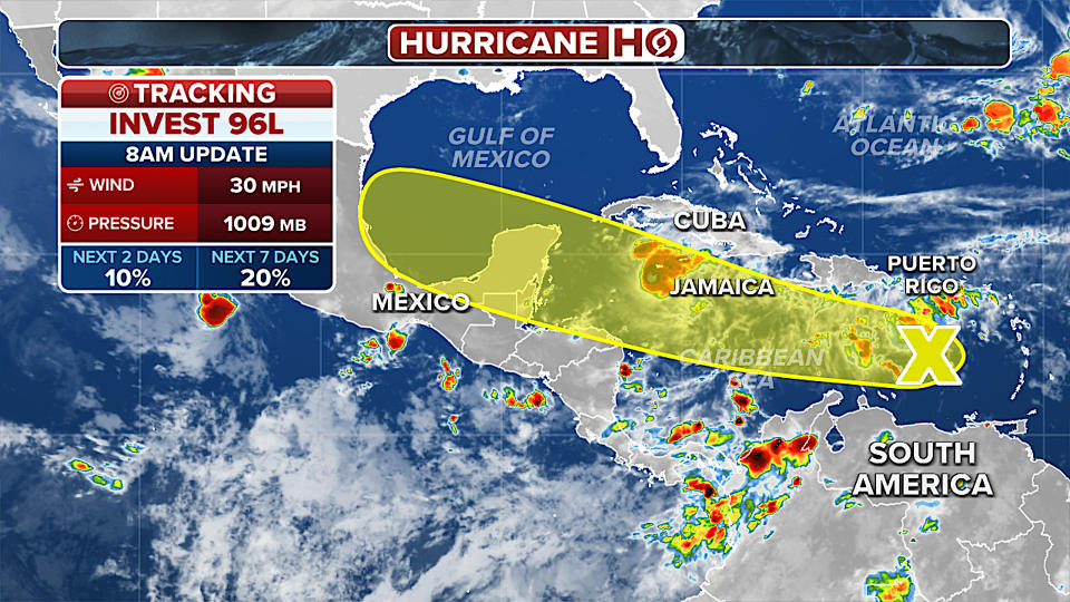
The system is causing gusty tropical downpours in Puerto Rico today. The National Hurricane Center is giving it a low chance of developing a circulation. It will most likely continue as a gusty moisture surge through the Caribbean.
A dense plume of Saharan dust will spread across the Atlantic over the next week or longer. So no further development is expected for a while.
Original article source: Bryan Norcross: Texas, Mexico watching and waiting for Hurricane Beryl

