
Severe thunderstorms threaten southern Ontario into the weekend
Prepare to change your plans and stay close to safe shelter on Friday as an approaching system threatens severe thunderstorms across portions of southern Ontario.
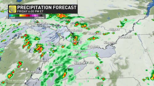
The threat will arrive during the afternoon and could continue into the overnight hours for some communities.
There is a non-zero tornado risk with some of these storms, but uncertainty remains high due to lack of forcing and thunderstorm energy available.
DON’T MISS: Scorching July heat, first 40°C day makes its way to Canada
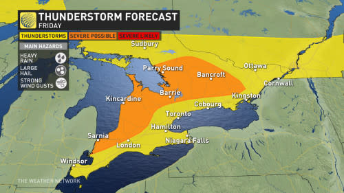
Severe storms possible on Friday
A disturbance approaching the Great Lakes to end the week will serve as the spark to kick off scattered thunderstorms as Friday wears on.
Daytime highs in the upper 20s throughout southern and eastern Ontario will combine with ample humidity to provide the fuel needed for thunderstorms to thrive once they bubble up.
Some of the storms could turn severe, especially from southwestern Ontario north into cottage country. This includes Sarnia, Barrie, and Bancroft. The severe threat should remain west of the Greater Toronto Area.
RELATED: A stormy start to the weekend in Ontario will turn to sunny, seasonal end
The greatest risk in the strongest storms will be heavy rainfall, large hail, and strong wind gusts. Slow-moving downpours could lead to localized flooding in some areas, so remain mindful of the risk for ponding on roadways if you encounter a heavy thunderstorm.
RELATED: Stuck in your car during a tornado? Here’s what you should do
Forecasters are closely watching the potential for a tornado risk to emerge in portions of eastern Ontario and cottage country. Some of the dynamics are present for a few thunderstorms to develop rotation.
However, this threat is conditional on ingredients coming together just right, and there’s low confidence right now. Continue checking back through the day Friday for the latest on this potential.
RELATED: Stuck in your car during a tornado? Here’s what you should do
WATCH: Ontario is now Canada's 'tornado capital'
Storms linger into Saturday
We’ll see a similar setup on Saturday as this slow-moving low lingers into the start of the weekend.
Scattered thunderstorms will be possible on Saturday afternoon throughout much of southern Ontario save for the southwestern corner of the province.
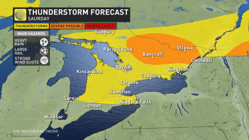
The risk for severe storms will remain through cottage country and into eastern Ontario. This threat includes Ottawa and Bancroft.
The stronger storms that pop up on Saturday will carry a similar risk to Friday’s severe storms, with the potential for heavy rain, large hail, and strong wind gusts.
Check back for all the latest on your forecast across Ontario.

