
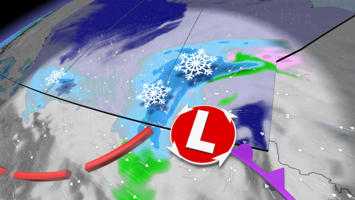
Snow continues to sweep across the Prairies, bringing tricky travels
It’s official! Edmonton has broken its snowless November streak, picking up a few cm of snowfall Thursday Morning.
The moisture from the pineapple express in B.C. is crossing the Rockies and will continue to spill onto the Prairies, continuing to bring snow to the region.
DON'T MISS: From blizzards to record warmth: Nunavut experiencing weather turmoil
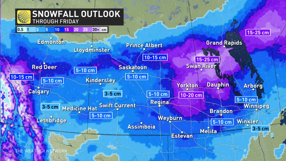
After a balmy Tuesday in Alberta, much colder temperatures have filed in, bringing with it some snow. There is an overachieve potential in Calgary snowfall accumulation on Thursday, possibly hitting the upper end of the 5-10-cm range. Some locations could even exceed that.
Snow will then spread elsewhere across the eastern Prairies as the system tracks farther east. Some areas could see anywhere from 15-25+ cm of snowfall accumulation.
This clipper won’t stop there, Saskatchewan and Manitoba are up next for the winter weather.
After some of the warmest temperatures on record in December, snow is forecast to continue along the QE2 and Trans-Canada Highway, migrating south to Calgary throughout Thursday. Evening commutes near and south of Calgary will be impacted by snowfall, but overall, conditions should improve throughout the day as the system tracks east. Remember that breezy conditions can cause reduced visibility on the roads as it blows the snow around, so exercise caution while driving.
5-15 cm is possible in the heaviest swath of snow that is forecast from Red Deer to Calgary. This comes after a month of below seasonal snow in November when Calgary only received 5.2 cm of snow the entire month.
There is the potential for some areas of Calgary to reach 10 cm or above, but a general 5-10 cm is expected. Farther west into the foothills and Rockies, heavy snow is expected with 15-30 cm of snow.
WATCH: Alberta clipper to bring hazardous commute to Winnipeg
Going somewhere? Check out the current highway conditions before heading out!
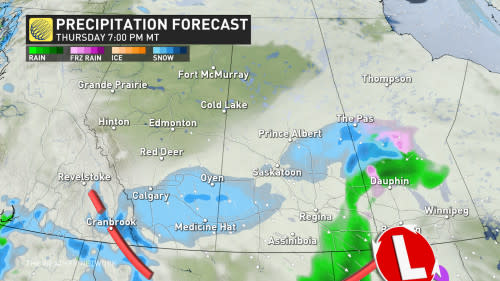
The system will track to the east throughout the day, bringing snow to the central part of Saskatchewan with some showers for southern areas.
Colder air is expected to travel south, bringing snow to southern Saskatchewan Thursday evening and overnight.
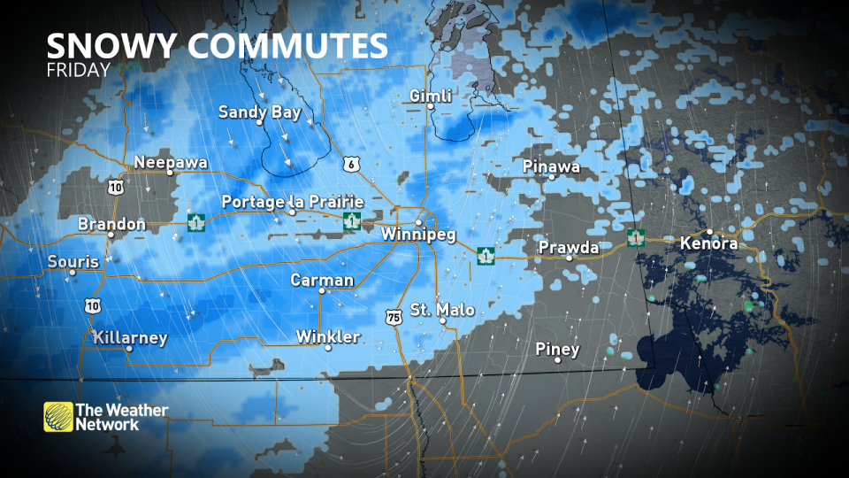
Snow continues for southeastern Saskatchewan Friday morning, with some gusty conditions reducing visibility. At this time, snow is on going for southern and central Manitoba, where some of the heaviest snow will fall. Snow continues through the evening and ends Saturday morning as the low tracks through northern Ontario.
10-20 cm of snow is expected for east-central Saskatchewan and into the Interlake region, with a swath of 5-10 cm of snow blanketing the rest of southern Saskatchewan. Heading east, near Winnipeg, totals will range from 3-10 cm.
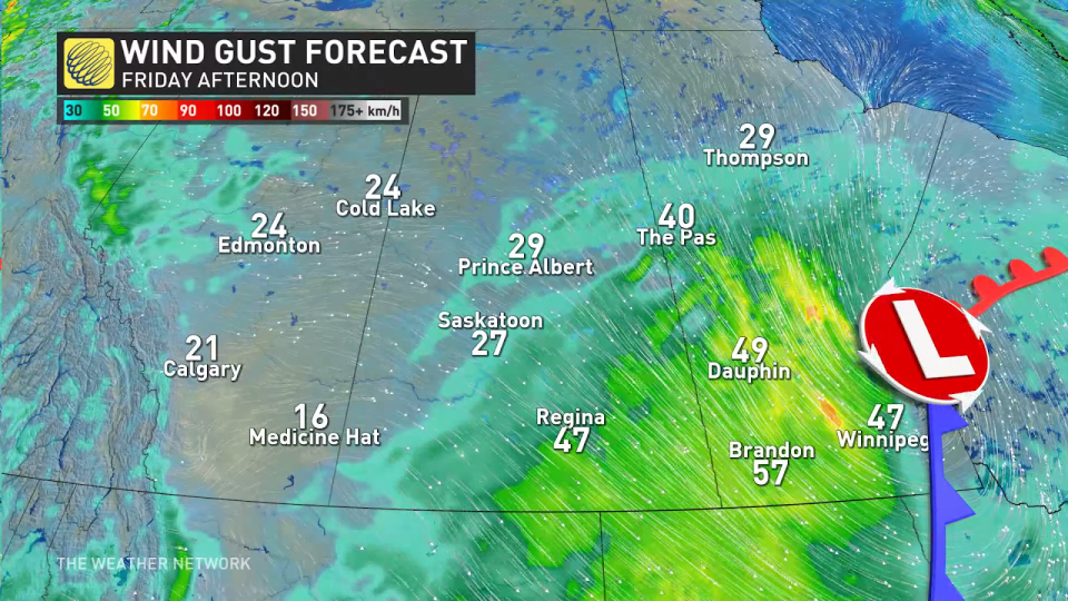
As the heaviest snow falls Thursday evening and into Friday, the eastern Prairies will experience near zero visibility as wind gusts of 40-60 km/h will scream over the region.
The good news is that no major systems are expected for next week.
For a look at what Alberta can expect during the winter, check out The Weather Network's seasonal outlook, here.
Stay tuned to The Weather Network for the latest forecast updates for Alberta.

