
California storm: Evacuations, shelters, flood warnings
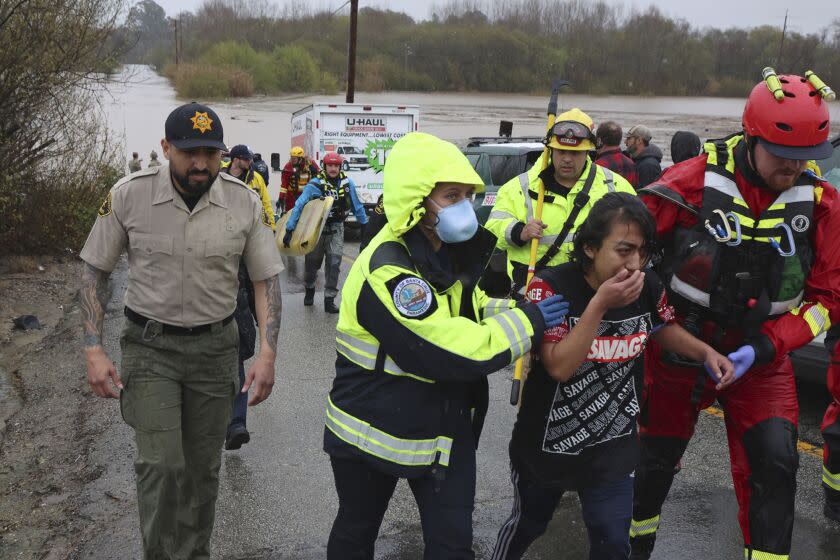
California is getting hammered by its 10th atmopsheric river storm of the season. Conditions are changing rapidly as the storm drops heavy rain and melts some of the state's record snowpack.
Below is a running list of flood watches, warnings and evacuation orders. It's advisable to check with authorities in your community for the most up-to-date information as the storm moves through the state.
Evacuations
Merced County: An evacuation warning was issued for areas near Bear Creek, which was approaching flood level. Any residents under evacuation warnings or orders can shelter at the Merced County Fairgrounds or the Atwater Community Center.
San Luis Obispo County: An evacuation order was issued for residents around the Arroyo Grande Levee and Oceano Lagoon.
Santa Cruz County: An evacuation order is in effect for some communities near the Pajaro and San Lorenzo rivers, as well as portions of Soquel and Paradise Park. A shelter-in-place order has been issued in Cherryvale, Glen Haven, Prescott and other neighborhoods north of Bates Creek.
Fresno County: An evacuation warning is in effect across a wide swath of the county, including areas around Pine Flat, Millerton Lake, Shaver Lake, Huntington Lake, and the Courtright and Wishon reservoirs.
Tulare County: An evacuation warning was issued for residents and businesses along the Kern River on Highway 99, from Mountain Road 50 to the Kern County line in Riverkern. The community of Ponderosa and homes from the Fresno County line to the Kings County line are also under evacuation warning.
Madera County: A mandatory evacuation order was issued for residents on the east side of Church Street in North Fork. The area was closed to the public, and residents were urged to leave immediately because of flooding. An evacuation warning was also issued for the Cascadel Woods subdivision east of the bridge.
Mariposa County: An evacuation warning was issued for the communities of Greeley Hill, El Portal, Bear Creek Cabins, the Oak Fire burn scar, Creekside Apartments, Hornitos and La Grange.
Kern County: An evacuation order is in place for Riverkern and low-lying areas of Kernville. Affected areas include the south of Riverkern, between Sierra Way and Burlando Road, north of the Kernville airport.
Monterey County: An evacuation warning was issued for low-lying areas of the Salinas River. An evacuation order also was issued for the Pajaro community.
San Benito County: A mandatory evacuation order is in place for residents in Mission RV Park, from Highway 156 to Salinas Grade Road and from Highway 156 to the Alameda Road.
Evacuation centers
The California Governor's Office of Emergency Services Director Nancy Ward said about 9,400 people were under evacuation orders statewide, and there were 15 evacuation shelters open across nine counties.
Open shelters include:
Merced County: The Merced County Fairgrounds and the Atwater Community Center.
San Luis Obispo County: An American Red Cross Shelter is open on the Cal Poly campus at the Crandall Gym. Pets are welcome.
San Benito County: The San Benito County Farm Labor Assn. Housing Center, at the SBC Migrant Center.
Santa Cruz County: Watsonville Veterans Memorial Building, Cabrillo College Gym (closes at 6 p.m.), Crosetti Hall at Santa Cruz County Fairgrounds, Depot Park.
Fresno County: The Sanger Community Center, 730 Recreation Ave.
Tulare County: Exeter Veterans Memorial Building (closes 8 p.m.), Porterville College Gym and Dinuba Memorial Hall (closes 8 p.m.).
Kern County: Kern Valley High School.
Flood watches and warnings
Dozens of flood watches and warnings were in effect across the state, according to the National Weather Service. They include:
Urgent flash flood warnings in portions of Fresno, Madera, San Luis Obispo, Tulare and Santa Cruz counties.
Flood warnings and advisories in portions of Santa Clara, San Benito, Fresno, Madera, Kings, Alamada, Sonoma, Marin, Inyo, Tulare, Santa Crauz, San Luis Obispo, Mariposa, Merced, Tuolumne, San Mateo, Kern, Santa Barbara and Monterey.
Winter storm warnings and advisories in several areas, including the eastern Sierra slopes and White Mountains of Inyo County; areas around Sequoia and Yosemite National Parks; portions of the Greater Lake Tahoe Area; and portions of Trinity, Mono, Lassen, Plumas, Humboldt, Siskiyou, Modoc and Del Norte Counties.
Avalanche warnings in the Greater Lake Tahoe Area, the eastern Sierra Slopes of Inyo County, south central Siskiyou County and Mono County between Virginia Lakes and Bishop Creek.
River flooding
The National Weather Service is forecasting flooding for at least 13 major rivers. They include:
the Eel River at Fernbridge
the Russian River at Hopland
the Salinas River at Bradley and Spreckels
the Carmel River at Robles Del Rio
the Merced River at Stevinson
the Cosumnes River at Michigan Bar and McConnell
the Eel River at Fernbridge
the Pit River at Canby
the Sacramento River at Tehama Bridge and Ord Ferry
and Bear Creek at McKee Road
Highway and road closures
Several highways and roads were closed because of downed trees, debris and flooding:
Highway 101 southbound in Gilroy was closed from 10th Street to Highway 25 due to flooding. Highway 101 from Highway 152 to Highway 25 was also closed.
Niles Canyon Road between Pleasanton and Fremont was closed due to flooding. Alternate routes can be found from Highway 680 to North Mission Boulevard or Highway 580 to 238.
Highway 152 was closed in both directions due to mud, debris and downed trees, according to Caltrans. The closures were at Holohan Road and Casserly Road/Carlton Road to the Santa Cruz/Santa Clara County line.
Highway 1 was closed from Ragged Point Inn in San Luis Obispo County to south of Deetjen’s Big Sur Inn in Monterey County
Highway 129 was closed from Murphy Crossing Road to Rogge Lane due to mud, dirt and rock.
Highway 135 was closed from Bell Street to Harris Grade due to mud and flooding.
Highway 101 closed its on/off-ramps at Marsh Street.
Highway 395 was closed from Pearsonville to Bishop, north of Bishop to Mammoth Lakes, Lee Vining to Bridgeport and from Sonora Junction to Walker.
Highway 168 East was closed from from Death Valley Road to Highway 266.
Highway 1 was closed from Morro Bay Boulevard to San Jacinto.
This story originally appeared in Los Angeles Times.

